yeovil at war
Yeovil anti-tank island
Yeovil's effort to thwart Hitler's invasion
Background
The following background is an extract from my e-book "The Taunton Stop Line"
During the early years of the Second World War, as far as the British were concerned, it was a certainty that Nazi Germany would invade Britain. On 27 May 1940 a Home Defence Executive under the leadership of General, later Field Marshall, Sir Edmund 'Tiny' Ironside, was formed to organise the defence of Britain. Ironside was appointed Commander-in-Chief Home Forces on 27 May 1940, replacing General Sir Walter Kirke - just as the British Expeditionary Force (BEF) was being brought home from France.
The 'Home Forces' Ironside now commanded, theoretically comprised some fifteen Territorial infantry divisions, an armoured division, fifty seven home defence battalions, and the Local Defence Volunteers. However, the vast majority of these units were under strength, un-organised, under-trained and poorly equipped - a problem severely compounded by the abandoning of the BEF's arms, equipment and materiel in France. It was because his force was so lacking and would not be mobile enough to face an enemy invasion with any rapidity or effect, that Ironside was compelled to consider a static defence of the country that would delay an enemy advance while relying on a strong central home force that could quickly mobilise and react to an invasion and not, as has often been said, because of a static 'war of attrition' mentality remaining from his First World War service.
Ironside's defence strategies to thwart the expected invasion were were quickly drawn up to prepare Britain as a battlefield. Indeed, he was to create what has become known as 'Fortress Britain'. These defence plans, like Hitler's plans for invasion, were ambitious and large scale. They covered almost the whole of the British Isles and involved the military and civilian populations. Because it was generally thought that an invasion would be largely sea-based, it was expected that the south and east coasts of England would offer the most likely landing places for troops and materiel. We now know that Hitler's plans for the invasion of Britain, Operation Sea Lion, did indeed provide for an invasion via the south and east coasts, extending from Ramsgate to Lyme Regis, as shown below.
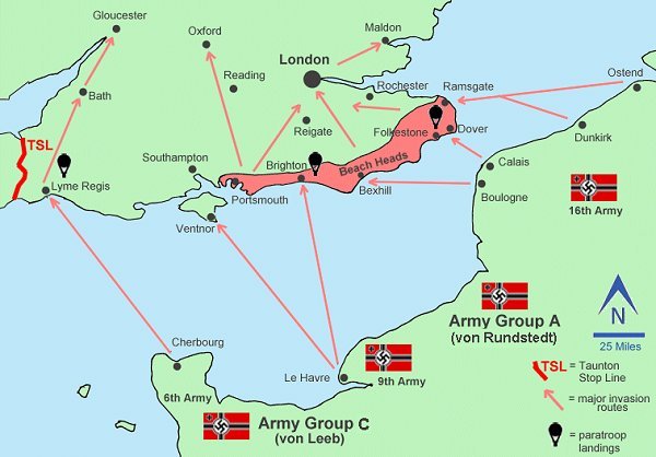
Hitler's
preliminary
invasion plans -
Operation Sea
Lion
Ironside's strategy to defend Fortress Britain, as explained to Churchill, the Cabinet and the Chiefs of Staff on 25 June 1940, comprised the following main elements -
-
A defensive "Coastal Crust". Initially Ironside planned for a 400-mile long line of coastal defences wrapping around the south, southeast and east coasts. This was extended to include other 'at risk' areas such as the Southwest Peninsular.
-
A series of "Stop Lines" to compartmentalise the coast and indeed the country, into sectors that would be more easily defended. First priority was to protect London and the industrialised Midlands.
-
A central reserve, of Corps size (between 20,000 and 45,000 men), that could be quickly mobilised and sent to deal with a major invasion at whatever point it was launched.
-
Area mobile units, possibly of Regimental size (3,000 to 5,000 men), to deal with subsidiary attacks, paratroop landings and the like.
-
At a local level, the Local Defence Volunteers would deal with local attacks, patrol the countryside and help delay German forces penetrating inland.
The overall strategy held that if a German invasion could be delayed sufficiently on the beaches by the Coastal Crust and then further delayed inland by the Stop Lines, the thrust of the invasion would lose its momentum and the initiative would pass to the defending forces who would have been bought enough time to muster and carry out a major counter attack.
While Ironside had a large force at his disposal for Home Defence, the majority were poorly trained and nearly all were poorly armed and equipped, especially since the BEF had left over 20,000 vehicles and most of their heavy guns and equipment in France. As a result Ironside had little option but to create a static and linear defence system across the country. A series of "Stop Lines" were proposed that would effectively compartmentalise much of Britain.
Ironside's plan to defend Britain was presented to the War Cabinet as Home Forces Operations Instruction Number 3 on 25 June 1940 although, in actuality, one of the nation's largest and most urgent construction programmes had already commenced at least two weeks before being officially sanctioned. During the summer of 1940 over 18,000 pillboxes of various types were constructed, mile upon mile of anti-tank trenches were dug and hundreds of miles of barbed wire entanglements were laid across the countryside turning the whole of the country into a fortress. Up to 100 stop lines, of varying complexity and depth, were planned with the majority being mostly completed by Autumn of 1940. The map below shows the proposed series of stop lines and coastal crusts for halting an enemy advance in Central Southern England.
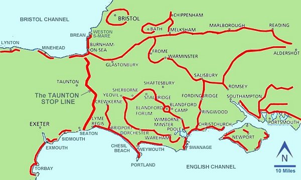
The planned
Stop Lines of
Central Southern
England - not
all were
completed.
The first thing to notice on this map is that Yeovil was at the end of two proposed stop lines. That running east via the outskirts of Sherborne, Stalbridge, etc. was never built but large sections of the stop line running south were constructed, especially around Maiden Newton near Dorchester, and remain to this day. Yeovil's pillboxes were almost certainly constructed as part of this stop line in the summer of 1940.
The only fully-functional stop line in south Somerset was the Taunton Stop Line which ran for some 50 miles (80 km), crossing the waist of the Southwest Peninsular from the Somerset coast at Pawlett, near Highbridge, passing through Somerset, Dorset and Devon, to Seaton on the Devon coast. Its purpose was to delay an invading force that had landed on the beaches of Cornwall, Devon or Somerset and slow down any advance further east towards Bristol and into the heartland of southern England so that troops from Ironside's Home Forces central reserve could be mobilised in order to meet the invading force.
By early July Churchill was becoming disillusioned by the progress being made by Ironside, especially with regard to Ironside's apparent tardiness in creating the mobile central reserve that was at the heart of his defence plans. The Secretary of State for War, Anthony Eden, suggested to Churchill that Ironside be replaced by General Sir Alan Brooke (later Field Marshall, 1st Viscount Alanbrooke).
Following the appointment of Brooke the strategy of stop lines tended to take a back seat. The call now was for a more fluid and aggressive strategy as outlined by Brooke above "...of a far more mobile and offensive nature" and the military planners came up with a solution - a defence strategy of anti-tank islands each of which had an all-round defence capability. The main purpose of the stop lines was to delay an enemy until central reserve troops could be deployed against the attack, but it was realised that an all-out onslaught against the thinly defended stop line may not offer enough time for the reserve troops to arrive. In other words linear defence is useless against armoured attack and defence in depth is essential.
Consequently the new strategy saw anti-tank islands as coordinated strong points set up with an all-round fire plan covering the whole area where enemy attacks were thought to be most likely. Anti-tank islands were located at what might be called 'choke points' along the expected line of German advance. Although enemy armour can travel across country, the main feature of the German Blitzkrieg was speed, and therefore to gain the maximum momentum for the attack the enemy armour would be more or less obliged to travel along the main arterial routes through the countryside. This meant that defence could be concentrated at a few more vulnerable locations.
The idea therefore was to prevent an armoured advance from racing across the country towards the heartland at speed. If the advance could be halted or slowed down, the momentum of the Blitzkrieg would be lost. It would either have to stop and fight or try to circumnavigate and pass through the gap between islands - all of which would be giving precious time for the defending armour to concentrate for a decisive counter-attack. Additionally, even if the advancing armour did get past the islands, the enemy infantry would be held up and become cut off from their tanks. Moreover, since the horse-drawn logistics vehicles would be unable to leave the main roads to cut across country and bypass the anti-tank islands, supplies for the advancing armour, such as fuel and ammunition, would be held back and prevented from re-supplying the attack.
The Yeovil Anti-Tank Island at January 1941
The planners of both the stop line and the anti-tank island defences went to great pains to ensure that urban centres and suburbs were completely excluded as far as possible. The problem is, of course, that if defences from the 1940's are plotted on a modern map then the majority of the defences appear to be located in 'urban centres and suburbs'. The reality however is that in 1940 the towns were only a fraction of the size they are today and post-war urban sprawl has resulted in many defence structures being removed and their sites built over.
Secret Home Guard Operational Orders for the Yeovil Borough Company, dated 15 January 1941 and now at Yeovil library, outlined the disposition of the troops detailed for the defence of the Yeovil Anti-Tank Island at this time as follows.
"In the event of an invasion of this country, Yeovil will form an Anti-Tank Island which will be defended by the 208th L.A.A. T.R. R.A. and the Yeovil Borough Company Home Guard, which latter will for this purpose be detached from the No 3 (Yeovil) Battalion Somerset Home Guard and come directly under the orders of the O.C. Yeovil Anti-Tank Island Garrison. Yeovil Anti-Tank Island is defended by an outer and inner circle of road blocks and the Yeovil Borough Company Home Guard will be responsible for the defense of Zone 1"
It should be borne in mind that the following is a snapshot in time and the composition of Yeovil Borough Company fluctuated throughout the war. Similarly the number and location of Yeovil's road and rail blocks also changed during the course of the war.
"In the event of an invasion of this country, Yeovil will form an Anti-Tank Island which will be defended by the 208th L.A.A. T.R. R.A. and the Yeovil Borough Company Home Guard, which latter will for this purpose be detached from the No 3 (Yeovil) Battalion Somerset Home Guard and come directly under the orders of the O.C. Yeovil Anti-Tank Island Garrison.
Yeovil Anti-Tank Island is defended by an outer and inner circle of road blocks and the Yeovil Borough Company Home Guard will be responsible for the defense of Zone 1 which consists of the following -"
Strong Point on Summerhouse Hill
Outer Road Blocks
-
Newton Road Railway Bridge
-
Top of Hendford Hill
Inner Road Blocks
-
Unknown
-
Unknown
-
Huish (near the junction with West Street)
-
Westland Road (near the junction with Beer Street)
-
Beer Street (near the junction with West Hendford)
-
West Hendford (near the junction with Beer Street)
-
Hendford (near the junction with Brunswick Street)
-
There was no Inner Road Block No 9
-
Brunswick Street (near the junction with Penn Hill)
-
Addlewell Lane (southern end)
-
Addlewell Lane (northern end)
-
Stars Lane (near the junction with Summerhouse Terrace)
-
Station Road (near the junction with Middle Street)
-
Newton Road (near the junction with Sherborne Road)
It was noted "In the defence of these posts every effort will be made to hold up and delay the passage of all tanks and other vehicles belonging to the enemy."
The Yeovil Anti-Tank Island at February 1943
By 1943, with the threat of invasion much lessened, the majority of regular army units had been withdrawn from the home defense role and posted to overseas theatres of war.
Secret Home Guard Operational Orders, dated 8 February 1943 and now at Yeovil library, began "It is anticipated that in the event of an invasion of this country, such invasion will be carried out by concentrated bombing attacks from the air, and landings by parachute and airborne troops. This may be followed by an attack by the enemies land forces after the enemy has been able to establish one or more bridgeheads where such troops can be disembarked. In these circumstances Yeovil will form an Anti-Tank Island, which will be defended by the Yeovil Borough Company No 3 Somerset (Yeovil) Battalion Home Guard.
It is intended that Yeovil Anti-Tank Island shall be defended by a series of defended localities, each consisting of a number of adjacent road blocks organised for all-round defence, and in addition Summerhouse Hill will be defended as an all-round Strong Point."
In November 1941 the 3rd (Yeovil) Battalion strength was around 2,500 of all ranks, with the Borough Company strength standing at 369.
The Yeovil Anti-Tank Island was formed in 1941, but by 1943 comprised at least twenty six road blocks, some of which were classed as 'Outer' blocks and some classed as 'Inner'. It is almost certain that some of these would have been on the railway tracks, technically known as rail blocks, since a tank could use the railway track-bed as easily as a road. The road/rail blocks were numbered and those whose locations are known are listed below.
-
Unknown
-
Unknown
-
Unknown
-
Ilchester Road (Outer Road Block) - Garrisoned by No 4 Platoon
-
Mudford Road (Outer Road Block) - Garrisoned by No 4 Platoon
-
Unknown
-
County Bridge over River Yeo - Garrisoned by No 1 Platoon and two sections of No 2 Platoon. The defences at this location included a Type 24 pillbox.
-
Near Newton Road railway bridge (Outer Road Block) - Garrisoned by No 1 Platoon and two sections of No 2 Platoon
-
Near junction of Crewkerne Road & Dorchester Road (Outer Road Block) - Classed as a 'Defended Locality' the defences at this location included a Type 24 pillbox and was manned by No 3 Platoon.
-
Unknown
-
Unknown
-
Unknown
-
Unknown
-
Town Station Road (Inner Road Block) - Garrisoned by No 1 Platoon and two sections of No 2 Platoon
-
Newton Road (Inner Road Block) - Garrisoned by No 1 Platoon and two sections of No 2 Platoon
-
Sherborne Road (Inner Road Block) - Garrisoned by No 1 Platoon and two sections of No 2 Platoon
-
Southville (Inner Road Block) - Garrisoned by No 1 Platoon and two sections of No 2 Platoon
-
Unknown
-
Unknown
-
Unknown
-
Unknown
-
Mudford Road (Outer Road Block) - Garrisoned by No 4 Platoon
-
Ilchester Road (Outer Road Block) - Garrisoned by No 4 Platoon
-
Preston Road (Outer Road Block) - Garrisoned by No 4 Platoon
-
Kingston - Garrisoned by No 4 Platoon
-
Higher Kingston - Garrisoned by No 4 Platoon
A sufficient stock of picks, shovels and crowbars to allow a distribution of two picks, two shovels and two crowbars for each road block were to be stored at each Platoon HQ. Other items to be issued from a central location (the QM Stores at the Territorial Drill Hall, Southville) included bombs, anti-tank mines, wire, sandbags, Northover mortars and other stores. The fact that picks, shovels and crowbars were allocated to each road block indicates that the blocks were simply temporary measures. However various types of road and rail blocks available to the Home Guard are discussed here.
Hitler's 'Blitz', the sustained bombing of Britain, had begun on 6 September 1940 and would last through to May 1941. Hitler's attention gradually shifted east towards Russia and the plans to invade Britain, Operation Sea Lion, were finally shelved and quietly forgotten. Of course, at the time this was all largely unknown to the British and the threat of invasion lived on, albeit in a much less heightened state, for the next couple of years.
Gallery
Probably the last remnants of the Yeovil Anti-Tank Island in the town are the remains of a "Hairpin" roadblock in Huish, opposite the junction of West Street.
For further information, see - Road Blocks.
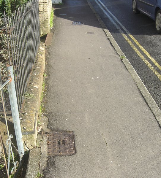
Remnants of the Inner Road Block No 3 of 1941 in Huish, near the junction with West Street (many thanks to Tony Robins for telling me about it). The two metal covers, one in the foreground and the second just in the shadow of the passing car, are the sole remnants of the Yeovil Anti-Tank Island. The covers were part of a 'hairpin' road block. Photographed in 2014.
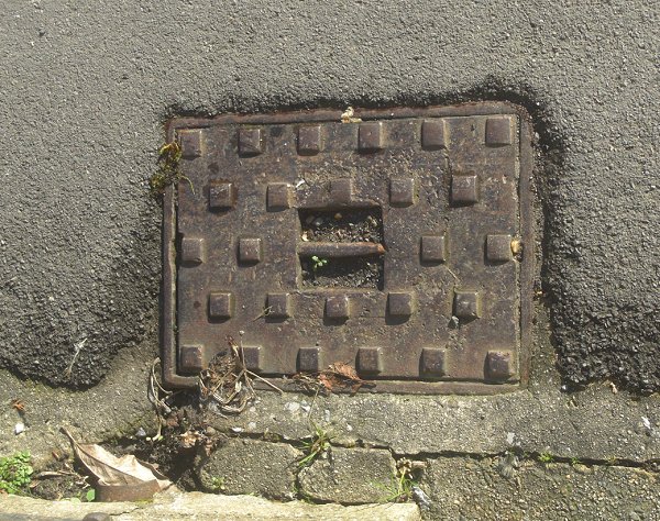
The western of the two road block covers. Photographed in 2014.
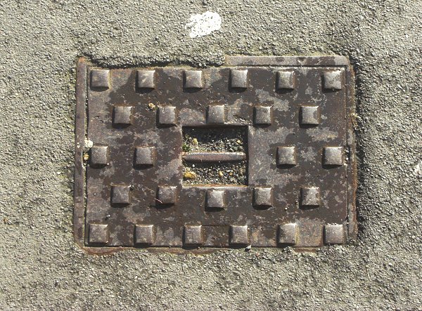
.... and the eastern cover. Photographed in 2014.
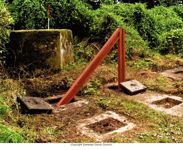
For clarification - a replica "Hairpin" road block fabricated for an Open Day at Dillington House in 2008. The original road block, T.RD.18 in the south drive of Dillington House, was part of the Ilminster Anti-Tank Island defences. Note the socket covers with steel handles which, when in place, would allow free access through the road block. Note also the reinforced concrete anti-tank cube - these were often used to close any gaps between a road block and other obstacles such as an anti-tank ditch.
Also, as with vertical rail type road blocks, if the block was sited on a road the rails may have been thoughtfully painted with a couple of broad white stripes, or blackout markings, to prevent traffic or pedestrians colliding with them after dark.