bare hills
bare hills
A field in the great Middle Field
Bare Hills, also known as Bearhills, was originally a large field in the great Middle Field of Kingston Manor. The origin of the name may come from the Old English bere meaning an area where barley was grown or, alternatively, may simply be a descriptive term for an unproductive area. It was located on the southern side of Milford 'Dip'. Even until the 1940s today's Milford Road, at its Goldcroft end, was simply a field access track.
The 1590 Terrier, referring to Middle Field noted "... in Edw(ard) Moleine close upon Beerhill... ".
In his will dated 15 March 1725, John Jeanes wrote "... And also those my two grounds called Long Closes and a ground called Bear hill All which said premisses are scituate lying and being in Yeovill aforesaid ...".
In June 1836, as advertised in the 13 June 1836 edition of the Western Flying Post (see Gallery) Bare Hills was sold by auction together with Higher Lydes and Lower Lydes. The owner was John Newman of Kingston.
By the time of the 1842 Tithe Map it had been divided into three smaller parcels, numbered 1008, 1009 and 1010. The Tithe Apportionment of 1846 noted that all three of the small fields had three separate owners and three separate tenants. All three were described as pasture. From the Tithe Map it would appear that a short drove connected central Bare Hills Parcel 1009 to Long Close (997) to its south and a similar drove from Bare Hills 1010 gave livestock access to Milford Brook to its west.
According to the 1846 Tithe Award -
Bare
Hills (1008) was
owned by
Thomas Dampier
and occupied by
Edward Wills
Jnr.
Bare Hills
(1009) was owned
and occupied by
Samuel Isaac.
It was inherited
by his
brother Thomas,
who sold it
after Samuel's
death in 1849.
Bare Hills
(1010) was owned
by William Neal
and occupied by
William Buck.
By 1896 Thomas William Dampier-Bide was Lord of Kingston Manor and owner of Bare Hills (1008) which had, by this time, been split into two closes called Barehill and Berry Mead. In June 1896 he sold the two fields at auction (see Gallery below).
Chelston Avenue was built along the eastern edge of former Bare Hills (1008) during (I think) the 1930s and in the late 1940s houses in Milford Road were built on its northern boundary and that of former Parcel 1009.
By the time of the Second World War, with the pressing need to grow food on every available piece of land, all three parcels of Bare Hills, together with Long Milford and plots 1017 to 1020 (to the west of Milford Brook) were being used as allotments. During the 1960s Melrose Road was built as infill between Milford Road and Chelston Avenue, completely filling the former Parcels 1008 and 1009 of Bare Hills.
Today, the former Parcel 1010 Bare Hills and the adjoining Long Milford (1011) are the only remaining area of green space in the area shown in the Tithe Map below. Where Long Milford has been completely re-landscaped to form a playing field (photographed below) Bare Hills (1010) still retains some of its natural topography but today is all but waste ground.
maps

This map, based on the descriptions in the 1589 Terrier and the 1846 Tithe Map of Yeovil shows the approximate boundaries of the Manors of Kingston and Hendford as well as the manorial three-field system used in Kingston.
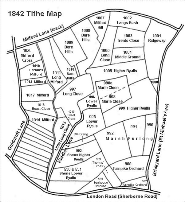
This map is based on the 1842 Tithe Map with field names added from the 1846 Tithe Award.
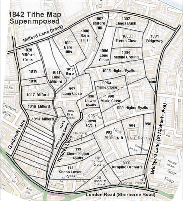
The 1842 Tithe Map superimposed (roughly) over a modern street map showing where several modern roads, for example Gordon Road, Grass Royal and Highfield Road, follow former field boundaries.
Gallery
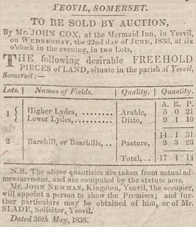
Notice of sale of Barehill in the 13 June 1836 edition of the Western Flying Post.
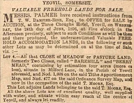
A notice of sale for Barehill and Berry Mead in the 5 June 1896 edition of the Western Gazette.
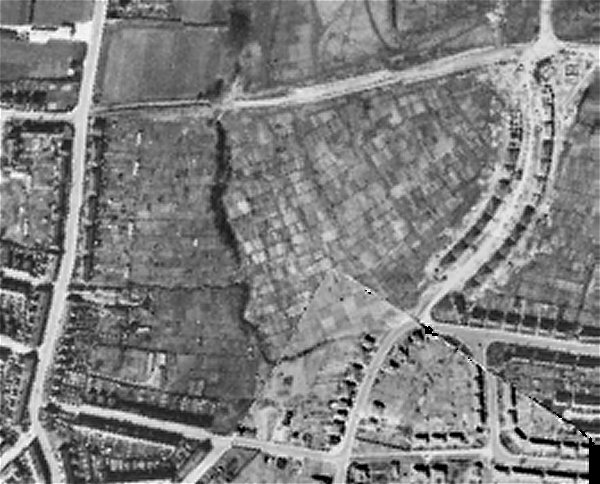
The 1946 aerial photograph shows Bare Hills being used as post-war allotments. Note that even at this time Milford Road was still only a farm track at its eastern end (top left). At left is Goldcroft and at right is newly-built Chelston Avenue. The ragged dark line running from Milford Lane down the photograph just left of centre are trees marking the route of Milford Brook. To its immediate right is Long Milford (Parcel 1011) and to its left are former Parcels 1017 to 1020, backing on to the rear gardens of properties in Goldcroft.
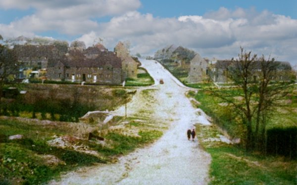
Milford 'Dip' seen from Milford Cross (at Goldcroft) in a colourised photograph of around 1950. The houses at right, in Milford Road and Melrose Road were built on former Parcel 1009 of Bare Hills. The former Bare Hills (1010) and Long Milford (1011) fields at right behind the trees and still being used for allotments in this photograph.
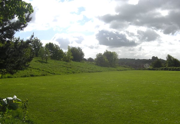
The former Bare Hills (Parcel 1010) to the left and Long Milford (Parcel 1011) to the right, heavily remodelled to form the current playing field. This is the only open space remaining from the Tithe Map area above. Photographed in 2014 from close to Milford Road looking southeast. Milford Brook, now presumably in a culvert, would have run from roughly where I stood to take the photograph in a more-or-less straight line in the direction of the house seen towards the right side.