Hundredstone
Hundredstone
Of Stone Farm, a detached part of Preston Plucknett
 Hundredstone
was a field on the
corner of Stone
Lane and Mudford
Road. This
field, the
highest point in
Yeovil and its
hinterland, is
named for the
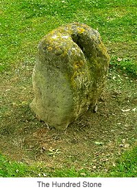
ancient Saxon
stone placed in
its southwest
corner - the
Hundred Stone.
Hundredstone
was a field on the
corner of Stone
Lane and Mudford
Road. This
field, the
highest point in
Yeovil and its
hinterland, is
named for the
ancient Saxon
stone placed in
its southwest
corner - the
Hundred Stone.
The 'hundred' was a tenth century Saxon division of the shire for judicial and military purposes. The geographic area of the hundred was the land required to sustain approximately one hundred households. The hundred usually took the name of the main town in the area but in Yeovil it was called the Hundred of Stone in reference to the local landmark, the Hundred Stone. This was the traditional hundred meeting place, where the Hundred Court was held.
The 1589 Terrier referred to the field as Hundred Thorne.
This area is actually a detached part of the parish of Preston Plucknett, known as Preston in Stone - the name itself deriving from the Hundred Stone still surmounting the field's highest point. The Preston Plucknett Tithe Map of 1849 shows Hundredstone as Parcel 182. It was bounded on the north by Bishops Ground (Parcel 181), to the west by Stone Lane, to the south by Mudford Road and to the east by fields in the parish of Yeovil.
The Preston Plucknett Tithe Apportionment of 1848 notes that Hundredstone was in the ownership of Henry Goodford Esq. of Chilton Cantello and occupied by Mrs Phillis Coles, as indeed was the whole of Stone Farm at this time. The Tithe Apportionment reckoned the area of Hundredstone to be 7a 2r 18p. In its northwest corner are springs that gave rise to the nascent stream that formed the Stone Farm re-entry into the Yeovil escarpment and also formed the parish boundary between Preston in Stone and the parishes of Yeovil and Mudford.
Other known owners / occupiers had been James Harris (1800), Mr Pester (1810), Mr Spear (1818), Stephen Coles (c1821-1827). Phillis Coles, in her later years assisted by her sons, ran Stone Farm after the death of her husband Stephen until her own death in 1877. Her son Edmund ran the farm after her death until his death in 1885. By 1886 a Mr Russell was farming Stone Farm but his widow sold up and retired in February 1900. In 1901 the tenant farmer was John Sawtell.
As seen in the aerial photograph of 1946, shown below, by this time the western side of Hundredstone had been taken up by houses and gardens, as was the southeast corner. The southwest corner of the field, containing the Hundred Stone, remained open as it does today although today it is landscaped with paths and planting. The northeast quadrant remained as pasture although in the very northeast corner were the springs and today this area is scrubland with some trees as seen in the modern aerial photograph below.
map and aerial photographs
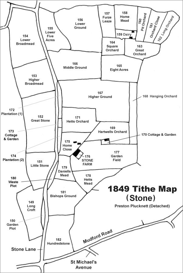
The Stone area reproduced from the 1849 Tithe Map. Hundredstone is the southernmost field in this sector.
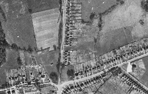
The 1946 aerial photograph showing Hundredstone at centre. The northeast quadrant remained as pasture at this time although the ground contained several springs that gave rise to the small stream that flowed northeast and then north, forming the eastern parish boundary of Preston in Stone. The southwest corner of the field, containing the Hundred Stone, remained open.
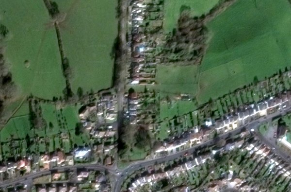
The modern aerial view showing Hundredstone at centre. The northeast quadrant remains as pasture although the ground containing several springs has become densely wooded. The relatively small section in the southwest corner containing the Hundred Stone is now landscaped with paths and planted beds.