Parcellas
Parcellas
Once part of the great medieval East Field of Kingston Manor
Parcellas was a field that had originally formed part of the great medieval East Field of Kingston Manor and was part of a large sub-field called Reckless Lake.
The name Parcellas may come from the Latin particula meaning a part, or piece, and parcella came to mean a parcel of land. On the other hand, and bearing in mind that the adjoining field was known as Priscilla's Close, perhaps in this instance Parcellas is a corruption of Priscilla's. Or could it be the other way around?
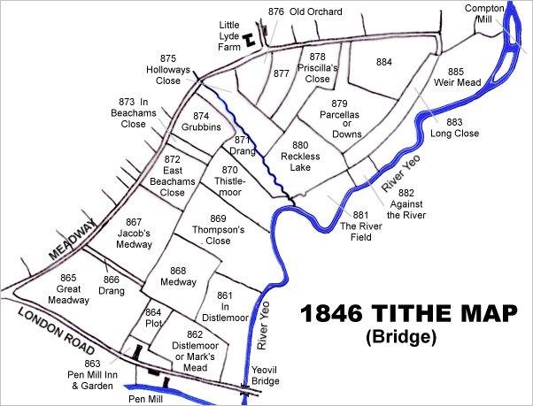
In any event Parcellas (Parcel 879) was shown on the 1842 Tithe Map and the 1846 Tithe Apportionment noted that Parcellas was owned by William Jones Prowse (Lord of Kingston Manor at that time) and the tenant was Thomas Frost. The Apportionment noted that it was used as meadow for producing hay and measured 6a 2r 30p.
A Counterpart of Lease for seven years dated 25 March 1859 between Captain William Prowse of Enham House, Southampton, Retired Captain RN, and John Stone of Pen Mill Inn for both the inn and the adjoining farm, included Parcellas, although at this time the field was known as Downs. The lease noted that the field was used as pasture for grazing livestock and measured 5a 0r 25p - the difference in area between this and that recorded in the Apportionment is probably due to the use of 'Statute' measurements in the Apportionment which were actually a different size to 'Customary' measurements, even though they both used the same units.
Parcellas (Parcel 879) was bounded on the northwest by Priscilla's Close (Parcel 878), on the southwest by Reckless Lake (Parcel 880) on the southeast by Long Close (Parcel 883) and on the northeast by the un-named parcel 884. Parcellas had a narrow projection to the north which allowed access from Lyde Lane.
Today Parcellas is covered by buildings of the Pen Mill Trading Estate, southwest of the northern bend in Buckland Road.
For details on historic land measurement (ie acres, roods and perches) click here.
maps & Aerial photographs

This map, based on the descriptions in the 1589 Terrier and the 1846 Tithe Map of Yeovil shows the approximate boundaries of the Manors of Kingston and Hendford as well as the manorial three-field system used in Kingston.

A map of the great medieval East Field of Kingston Manor showing conjectured locations of several fields based on descriptions in the 1589 Terrier.
This map is based on the 1842 Tithe Map with field names chiefly added from the 1846 Tithe Apportionment.

The 1842 Tithe Map superimposed (roughly) over a modern street map. Bearing in mind the relatively primitive surveying equipment of the 1840s they weren't all that far out.