Salthouse Orchard
Salthouse Orchard
Remnant of the medieval common field called Hewish Field
The great medieval field called Northover (see first map below) was later broken up and part of it became a large common field called Hewish, or Hewish Field, stretching from Ram Park in the north, the boundary with the parish of Preston Plucknett in the west, today's West Hendford in the south and roughly as far as today's Clarence Street in the east. The parcels comprising the former great common field called Hewish Field are shown shaded green in the 1842 Tithe Map below.
The name Huish, in its various spellings through time, derives from the Old English 'hiwisc' meaning a household.
On 1 July 1415 Thomas, Earl of Arundel, granted the advowson of Yeovil Rectory to Henry V with "two acres in the field called Huysh".
It was recorded that in 1611 St Leonard's Fair for rother cattle was held in "the field called Huishe in Hendford" - in this instance Hendford being the Manor of Hendford, not the road of that name. As a sidenote; the word 'rother' is an old Anglo-Saxon word for cattle. The rother cattle were long-horned, fleshy beasts prized for their meat, milk, hide and horn (see photo here).
An indenture of 1715 remarks on six acres of arable land "lying in a common field called Hewish in the tything of Hinford.... lately enclosed" - the words 'lately enclosed' being a good indication of when this common field began to be parcelled up.
In his will of 1795, banker Samuel Daniell left "...a certain Orchard in Yeovil aforesaid called Salthouse Orchard with the Garden or Nursery adjoining which Orchard I lately had in exchange of Mr John Ryall unto my Wife Melloni Daniell...".
By the 1800s the division parcels of Hewish Field were more or less finalised as shown in the 1842 Tithe Map below.
One of these division parcels of the former common field was Salthouse Orchard (Parcel 310) and its subdivision Salthouse Orchard Garden (Parcel 310a). The 1846 Tithe Apportionment noted that both Salthouse Orchard and Salthouse Orchard Garden were owned by Rev. Arthur Daniell Johnson and the tenant was Maria Bullen. Salthouse Orchard was recorded as an orchard measuring 2a 1r 19p and Salthouse Orchard Garden was noted as arable measuring just 0a 2r 3p. Maria Bullen was the licensee of the Three Choughs Hotel from 1828 until at least 1866 and probably used the apples from the orchard for cider making since the Three Choughs had its own brewhouse.
Salthouse Orchard and Garden were bounded on the north Priddle's Orchard (Parcel 606) and Croft (Parcel 309), on the west by Hibbard's Orchard (Parcel 311), on the south by Horsey Lane (today's West Hendford) and on the east by Salthouse Lane - which clearly gave its name to the orchard.
Today the former Salthouse Orchard and Salthouse Orchard Garden are covered by the houses and gardens of The Crescent although, of course, this was bisected in the 1970s by the construction of Queensway.
For details on historic land measurement (ie acres, roods and perches) click here.
maps

This map, based on the descriptions in the 1589 Terrier and the 1846 Tithe Map of Yeovil shows the approximate boundaries of the Manors of Kingston and Hendford as well as the manorial three-field system used in Kingston.
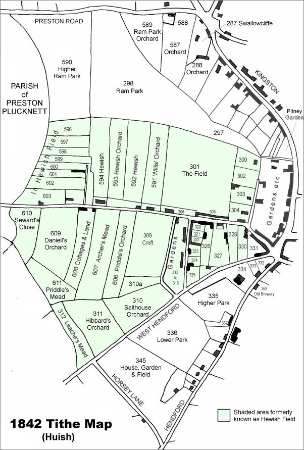
This map is based on the 1842 Tithe Map with field names added from the 1846 Tithe Award. The area shaded light green was originally a large common field called Hewish Field that had been formed out of the earlier medieval field called Northover. By the time of the 1842 Tithe Map, shown here, Hewish Field had been further sub-divided into many parcels as shown.
Salthouse Orchard is at centre, towards the bottom.
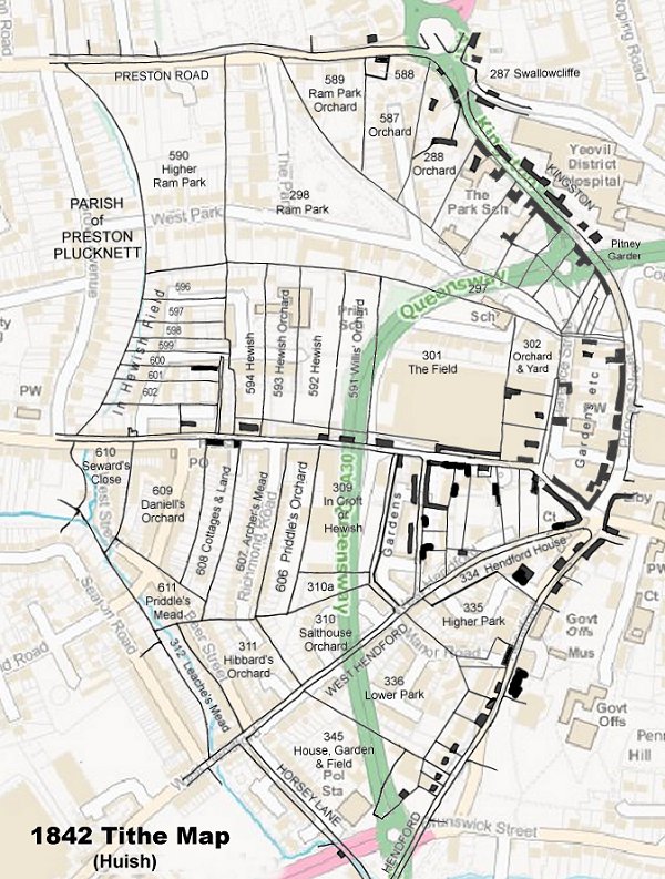
The 1842 Tithe Map superimposed (roughly) over a modern street map showing where several modern roads, for example the rear gardens of the eastern side of Grove Avenue, follow former field boundaries.