West Field
West Field
A former part of the great West Field of Kingston Manor
Originally West Field was one of the great medieval fields of the Manor of Kingston that covered the area between Larkhill Road in the east, Preston Road in the south, Ilchester Road to the east and Combe Street Lane to the north. However, by the early nineteenth century this great field had been subdivided into a myriad of small fields. The field under discussion here was the last vestige of the former manorial field that retained the name until the middle of the nineteenth century.
In 1741, the year before his death, glove manufacturer Henry Penny (1691-1742) purchased for £60 (around £110,000 at today's value) ".... one Orchard five acres of Land and three acres of pasture with the Appurt(anences) in the Parishes of Yeovil Kingston near Yeovill & Pitney...." from William Newman, a cordwainer, his son William Newman Jnr. and his wife Sarah.
An indenture dated 6 April 1743 refers to West Field, which, after the death of Henry Penny passed to his widow Mary (his second wife) and his younger son Boon (by his first wife), a 'Clothyer', who were leasing West Field to Ralph Phelps, Gent., of Lyons Inn, Middlesex, for one year. In the indenture West Field was described as "All those (two ?) acres of Arable Land (be the same more or less) lying and being in Yeovill aforesaid a certain Field called West Field at or near a place there called Butter Corner (see Batt's Corner) late in the possession of the said William Newman and since of the said Henry Penny...."
Boon Penny was in the Royal Navy and died on Foreign Service in 1765. On his death West Field passed to his eldest son, also Henry Penny (1746-1796).
Madeley's 1831 map of Yeovil shows West Field as a rectangular field and Bidder's map of 1843 notes that the field was owned by Henry Penny (1778-1855, the son of the above Henry and the grandson of Boon Penny).
By the time of the 1842 Tithe Map West Field had been divided into five different parcels as follows -
Parcel
1463
This was a long,
thin strip of
land - the most
western part of
the West Field
of 1831. It was
bounded on the
north by
Long Ground
(Parcel 1436),
on the west by
Preston Lane
Orchard
(Parcel 1462),
on the south by
Preston Lane
(today's Preston
Road) and on the
west by West
Field (Parcel
1464). The
1846 Tithe
Apportionment
noted that this
parcel of West
Field measured
1a 2r 0p and was
arable land. The
Apportionment
recorded that
the owner was
Mary Marshall
and the tenant
was Sarah
Bengefield.
Parcel
1464
Another long,
thin strip of
land to the
immediate east
of Parcel 1463
above. It was
bounded on the
north by Long
Ground (Parcel
1436), and on
the south by
Preston Lane. To
its west was
Parcel 1463
(above) and to
the east was
Parcel 1465
(below). The
1846 Tithe
Apportionment
described this
parcel of West
Field as 'House
& Land' and
noted that it
measured 0a 3r
25p and was
arable land. The
Apportionment
recorded that
the owner was
Betty Bengefield
who lived in the
house.
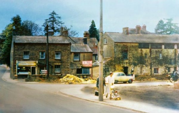
In fact the house that Betty Bengefield owned and lived in was known as Providence Cottage (see Gallery below) which was shown on Madeley's 1831 map of Yeovil. At some time in the middle of the nineteenth century a tannery was built on this parcel, complete with tanning pits, consisting of two nearly parallel ranges of buildings on a north-south axis. The site was probably operated by William Phelps in the 1850s and later by John Baker, a fellmonger, glove and gaiter manufacturer, listed in trade directories of 1875 and 1883. The 1886 Ordnance Survey showed the range of buildings as 'Tannery (Disused)'. By 1897 James Henry Newis, a corn merchant, was living at Providence Cottage he converted the adjoining former tannery into a flour mill, known as Newis' Mills. In 1914 his business was known as JH Newis and Sons. 'Newis Mills (Corn)' is marked on the 1928 Ordnance Survey map located within the existing buildings (see Gallery below). At some time after 1901 (but before 1927) a short terrace of three houses was built facing Preston Road to the immediate west of Providence Cottage. The three houses remain but Providence Cottage and the former Newis' Mills were demolished in the late 1960s and replaced with housing on the junction of Preston Road and Willow Road (see Gallery).
Parcel
1465
A third long,
thin strip of
land to the
immediate east
of Parcel 1464
above. It was
bounded on the
north by Long
Ground (Parcel
1436), and on
the south by
Preston Lane. To
its west was
Parcel 1464
(above) and to
the east was
Parcel 1466
(below). The
1846 Tithe
Apportionment
described this
parcel of West
Field as
measuring 0a 3r
6p and used as
arable for
growing crops.
The
Apportionment
noted that this
parcel was owned
by
Yeovil Almshouse
and the tenant
was William
Buck.
In fact the Woborn Almshouse records for this particular parcel go back to 1559 at which time it was known as 'Cattle Lake'. For a complete list of people who rented it click here.
This parcel was used as allotment gardens from at least 1901 until at least 1938 and possibly into the 1950s. It was sold in 1960 and today the former field is occupied by the houses and gardens of the southern end of Willow Road.
Parcels
1466 and 1466a
These two
parcels, the
largest of the
subdivisions of
the 1831 West
Field, remained
in the ownership
of Henry Penny
at the time of
the 1846 Tithe
Apportionment
with William
Buck as the
tenant. The
Apportionment
noted that the
acreage of the
two parcels was
5a 1r 15p and
used as arable
for growing
crops. These two
parcels were
bounded to the
north and west
by
Brice's
Orchard (Parcel
1434), to the
west by Parcel
1465 and on the
south by Preston
Lane.
By 1859 these two parcels of West Field had been purchased by the Town Council who wanted the land for the new Yeovil Cemetery - which it remains to this day.
In a sworn statement dated 23 April 1859, William Jacob recalled "I William Jacob of Yeovil in the County of Somerset Glover Do solemnly and sincerely declare as follows - I am about Eighty five years Old and was born and have always lived in the parish of Yeovil aforesaid. I was for Thirty three years in the employ of the late Mr Henry Penny Glove Manufacturer previous to his giving up business in or about the year One thousand eight hundred and thirty two. I very well remember his father whose Christian name was also Henry (Boon's eldest son) and who died about the year One thousand seven hundred and ninety six. He was as long ago as I can recollect the reputed and as I always understood the absolute owner of a close of Arable Land called West Field situate in Preston Lane in the parish of Yeovil lately purchased by the Corporation of Yeovil for a Cemetery except a part on the Western side which was held by lives under the Yeovil Almshouse and fell into their hands on the late Mr Penny's death. I have however been lately informed that about one Acre of the Field was purchased many years ago by my late Master of the Earl of Egremont. I never heard of this before nor do I know its situation for during all my recollection there has been no fence or boundary to distinguish it. Mr Edward Boucher was the Tenant of the said field when I was a boy in Old Mr Penny's life time. Upon the death of Old Mr Penny his said Son my late Master became the owner of the said Field and held it down to the time of his death in the year One thousand eight hundred and fifty five and Jacob Marsh, John Stevens and William Buck were successively his Tenants. I recollect many years ago my late Master purchasing a small Orchard which formerly belonged to Mr John Ryall adjoining that part of West Field nearest the Town and lying between the field and the Road and soon after he purchased he had the hedge between the two thrown down and the Land added to the Field of which it has formed a part ever since and occupied by the tenants thereof."
For details on historic land measurement (ie acres, roods and perches) click here.
maps & Aerial Photographs

This map, based on the descriptions in the 1589 Terrier and the 1846 Tithe Map of Yeovil shows the approximate boundaries of the Manors of Kingston and Hendford as well as the manorial three-field system used in Kingston.
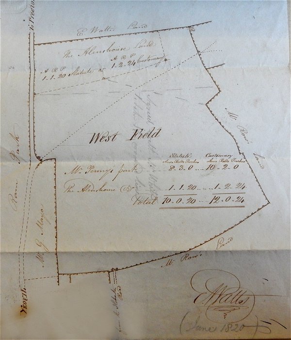
A plan by E Watts of 1820 showing West Field - north is to the right and Preston Road runs along the left edge of the plan. This plan was produced in evidence as proof of ownership of the land at the time it was bought by the Corporation for the purpose of creating the cemetery. Its importance however is that it shows that two systems of land measurement, ostensibly using the same units, were being used concurrently.
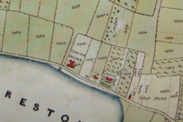
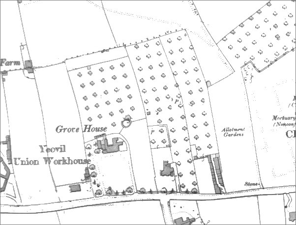
A section of the 1842 Tithe Map showing Preston Road running from centre left to bottom right with the Union House at centre and Grove House at right of centre. The several parcels of West Field are in the bottom right quadrant.
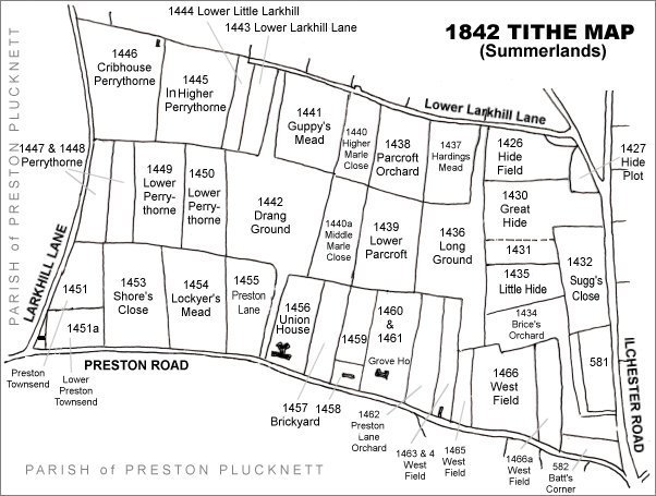
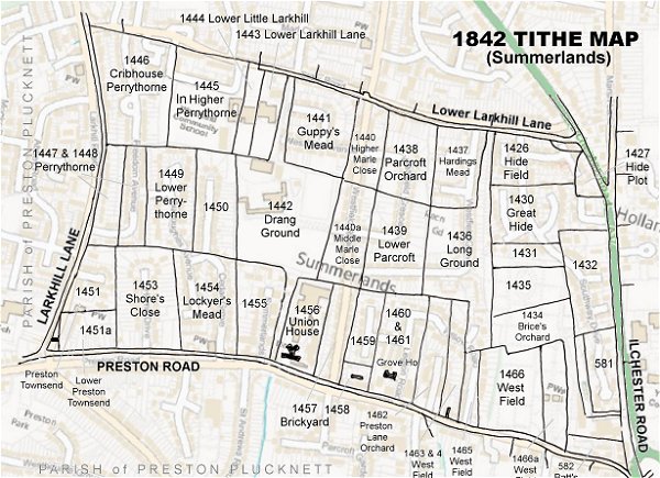
The Larkhill area reproduced from the 1842 Tithe Map. The several parcels of West Field are in the bottom right quadrant.
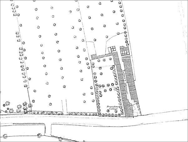
Map based on the 1886 Ordnance Survey showing Providence Cottage and Newis' Mills (in Parcel 1464). On this map the mills were marked as 'Tannery (Disused)' indicating that Newis had yet to make the conversion to a flour mill.
Map based on the 1901 Ordnance Survey showing Parcels 1463 and 1464 of West Field containing Providence Cottage and Newis' Mills next to Preston Road. Parcel 1465 is noted as 'Allotment Gardens'.
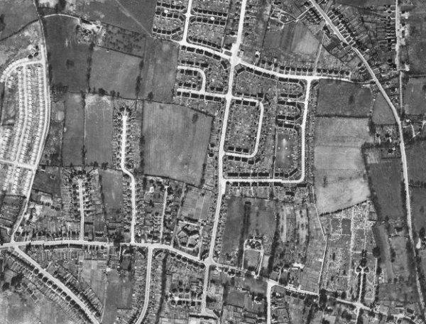
The 1946 aerial photograph - Parcel 1465 is seen to be still used as allotment gardens at bottom right, next to Parcels 1466 and 1466a that are now used as Yeovil Cemetery.
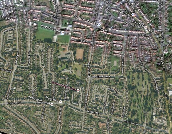
The same area today 'borrowed' from Google maps.
The 1842 Tithe Map superimposed (only very slightly out at the bottom) over a modern map.
Gallery
![]()
An extract from an indenture dated 6 April 1743 (I've added the red lines on the image) which says ".... certain Field called West Field at or near a place there called Butter Corner...."
From the Cave
Collection
(colourised),
Courtesy of South Somerset Heritage Collection
The original of
this
photograph
features in my
book "Lost Yeovil"
This photograph was taken in the 1960s and looks west along Preston Road and the road running off to the right is Willow Road. The three-bay house end-on to Preston Road with a corner shop in its left-hand side is Providence Cottage. The building at right was originally a leather tannery but converted into a flour mill known as Newis' Mills. Both cottage and mills were demolished shortly after this photograph was taken.
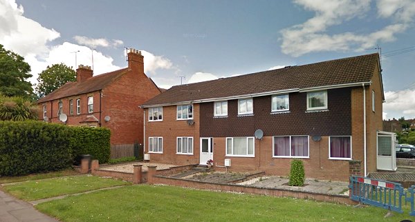
The three houses at left were built after 1901 to the west of Providence Cottage, which itself was replaced by the houses at right on the corner of Preston Road (where the photograph was taken from) and Willow Road off to the right.