yeovil at war
barrage balloon sites
Protecting Westlands airfield and factory
Balloon Command, formed on 1 November 1938, was the RAF command responsible for controlling all the United Kingdom-based barrage balloon units during the Second World War and was established to protect cities and key targets such as industrial areas, ports and harbours. The country was broken down into areas known as Balloon Centres. There was also a balloon school at Cardington in Bedfordshire.
The balloon squadron at Yeovil was 957 Squadron, a part of No 32 Group headquartered at Claverton Manor near Bath from 1 March 1939 to 15 November 1944. 957 Squadron had their headquarters at Braggchurch House the former home of John Vincent. Balloon Command was disbanded in February 1945.
Barrage balloons were intended to defend against dive bombers and were set to fly at heights up to 5,000 feet (1,500 m) although were often deployed at an operational height of 6,500 feet. The balloon and its steel cable were a danger to any aircraft that tried to fly among them consequently forcing them to fly higher and into the range of concentrated anti-aircraft fire, since anti-aircraft guns could not traverse fast enough to attack aircraft flying at low altitude and high speed.
By the middle of 1940, there were 1,400 balloons spread across the country, a third of them over the London area. By 1944 the number had risen to nearly 3,000. Somerset had two barrages, at Yeovil and at Weston-super-Mare, to protect vital aircraft factories. Both barrages were in place by July 1940.
The balloon barrage was operated by the Royal Air Force. Balloon squadrons were manned almost entirely by Royal Auxiliary Air Force personnel or, in some cases, women of the Women's’ Auxiliary Air Force. Some WAAFs were stationed in Yeovil at, for example, Yeovil Barrage Balloon Site No 2, "Watercombe Road, Barford" (that is, Bunford).
957 Squadron, operating the Yeovil balloons, was responsible for the defence of Yeovil. It assumed this task on 24 July 1940. The Yeovil Squadron would have consisted of just under four hundred personnel. They are believed to have been accommodated at the individual sites, initially in tents and later in Nissen huts.
Each balloon site was manned by two corporals and ten men, or by two corporals and fourteen women. 957 Squadron also assumed control of the local “Starfish” decoy site at Brympton from 1 June 1941. Although not specifically mentioned, it can be assumed that the QF/QL decoy site at Closworth would also have been included.
In Yeovil twenty-four barrage balloons were deployed around Westlands airfield and factory in a barrage that extended from Brympton d'Evercy in the west to Wyndham Hill in the east and from today's Stourton Way in the north to Keyford roundabout off the Dorchester Road to the south. In February 1943 the number of balloons in the Yeovil barrage was reduced to twenty.
Each balloon was moored to a wagon by a cable. These cables were strong enough to destroy any aircraft colliding with them. On the wagon was a winch that enabled the crew to control the height of the barrage balloon. A Balloon Crew originally consisted of two corporals and ten other ranks, but this was reduced to two corporals and eight other ranks. In the early days all crews were men, but women were quickly assigned to the role in order to release men for fighting overseas. Clearly, between two hundred and two hundred and fifty balloon personnel were deployed in Yeovil. Initially accommodation was in tents and rations were supplied in hay boxes from central kitchens, later Nissen huts were provided and food could be cooked on the individual premises.
The balloons used were the Low Zone version, inflated by approximately twenty thousand cubic feet of hydrogen gas. They were fitted with relief valves, which released gas from time to time to prevent them from reaching too high an altitude, or to prevent pressure rising to excessive levels in sunny conditions. Consequently the balloons required topping up with hydrogen at regular intervals. When operating for defence purposes, the balloons were flown at an altitude of about 1500m. They could be close hauled to 150m when not operating. Being in close proximity to the Westland airfield they would have spent most of the time being close hauled. They were normally controlled by means of a winch mounted on a three axle Fordson lorry. This was able to winch the balloon in at a rate of about 125m per minute. The hydrogen was supplied from an Imperial Chemical Industries plant specially built to supply the hydrogen to units in the south-west. It was located beside the town gasworks in Weston-super-Mare.
The balloons normally operated from fixed bases, typically a circular concrete pad of about 11m in diameter, surrounded by a circular fence at some distance from the pad. Where the site was not adjacent to a road an access track, often a loop was built near to the circular pad. Road access would be required not only for the balloon winch truck but also for transport of the heavy cylinders of pressurised hydrogen gas required to top up the balloon. Some method of communication would probably have been provided, as the requirements of test flying at Yeovil, would have necessitated the frequent winching down of the barrage, or alternately to quickly erect the barrage on the approach of enemy aircraft, if the barrage was not normally flown.
The balloons were very vulnerable to weather damage, particularly lightning strikes and gales, not to mention enemy action. On at least two occasions it was recorded that enemy aircraft had machine gunned balloons in the Yeovil barrage. On the 12th December 1941 during an air raid two balloons were shot down. The balloons were also machine gunned during the evening of 8th August 1942 but no damage was reported on that occasion.
Overall length of a barrage balloon (with stabilisers inflated) was 64.2 feet (19.5m), overall width (with stabilisers inflated) was 33.7 feet (10.3m) and overall height to the bottom of the rudder was 31.8 feet (9.7m). The gas volume was 19,150 cubic feet (54.2m3) and the unfilled weight of a balloon was 565 pounds (256 kilos).
Barrage balloons used in the defence of Yeovil were repaired at St Michael's Hall, the only hall large enough in the vicinity to accommodate a fully-inflated balloon.
On 21 June 1944 the Yeovil barrage was sent to the south coast as part of the Anti-Diver measures to combat approaching V-1 unmanned flying bombs.
|
Yeovilians
remember... |
Casualties of No
957 Squadron
whilst at Yeovil
The following
four servicemen
are recorded as
having died
whilst serving
with the
squadron. No
details of the
circumstances of
their deaths are
known.
- Chivers,
Frank 985665
Aircraftsman
1 RAFVR died
6th December
1940 aged
26. Husband
of Frances
Chivers of
Bridlington,
Yorks.
Buried
Bridlington
Cemetery,
Yorks.
- Shinn,
Herbert
Stanley
965992
Aircraftsman
2 RAFVR died
21st March
1941. No
known grave.
Commemorated
Runnymede
Memorial,
Berks.
- Austin,
Victor
Marcel
Spencer,
535414
Leading
Aircraftsman
RAF died
11th
November
1941 aged
23. Son of
William
Spencer and
Rosemary
Austin of
Doncaster.
Buried
Bentley with
Arksey New
Cemetery,
Yorks.
- Reed, Albert , 859611 Ldg. Aircraftsman RAuxAF died 1st November 1943 aged 44. Son of Henry and Elizabeth Reed of Bristol. Husband of Evelyn Reed (nee Gould) of Bristol. Buried Bristol (Canford) Cemetery.
|
Yeovilians
remember... I lived near the Western Gazette in Sherborne Road and one was located at the bottom of Wyndham Hill. There were two warnings to activate them. A 'Yellow' which made them go aloft a few hundred feet, which we took note of, so that if there was real danger 'Red' they could be sent aloft all the way. In a high wind they did not go aloft. However sometimes a sudden gale would catch them whilst they were aloft and before they could be retrieved. This happened on one occasion to the balloon at Wyndham Hill. The gale blew up from the South, the silvery Elephant came over my way and although the operators had reeled it in somewhat, it was right over the houses at the bottom of Middle Street with the wire scraping and screeching on the slate roofs. Some folk wondered how they made the wires stiff enough to hold up the balloons !!!"
Memories
of the
late
Walter
McGowan
"My barrage balloon training took place at RAF Titchfield, Wilts where I learned about winches, splicing ropes and theory. Practical experience was gained at Southampton before going to an operational Barrage balloon site at Yeovil; Somerset to protect the Westland Aircraft factory. These balloons carried armaments (small explosive charges) attached to cords hanging underneath. We inherited a football playing dog trained by our predecessors who were male (balloon companies at that time were all men or all women) We also had a goat as a mascot and I made the mistake of taking it to bed one cold night and caught fleas. The medical officer was not amused and had the kid removed. An accident involving my friend Olive Daniels contributed to women being removed from barrage balloon duty. She was guiding the cable on to the drum during a balloon descent when her glove caught and her fingers were broken. The corporal ordered the winch driver to reverse the winch which resulted in Olive's arm being broken-I can still remember hearing her screaming. It was heavy work for women and there was the danger of injury from concrete anchor blocks flying through the air when the balloons were caught in gusts of high wind and pulled the blocks from the ground. I remember being told to obtain sharp knives from the kitchen to puncture a barrage balloon as the gas outlet valve had jammed and the balloon was out of control."
Memories
of Mary
Knight-Smith
|
Yeovil Barrage Balloon Site No 1, "Camp Road West Coker", south of Leaze Plantation, West Coker. A barrage balloon site can be seen on the RAF vertical air photographs of 1946. As well as the circular concrete base three Nissen huts and the loop road for the winching lorry can be seen to the west.
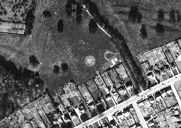
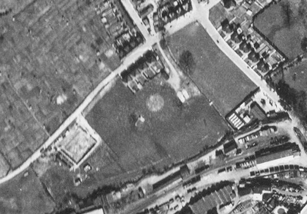
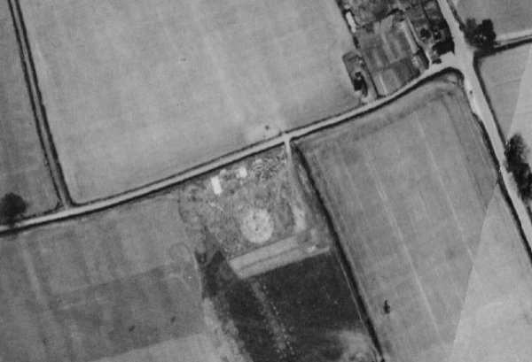
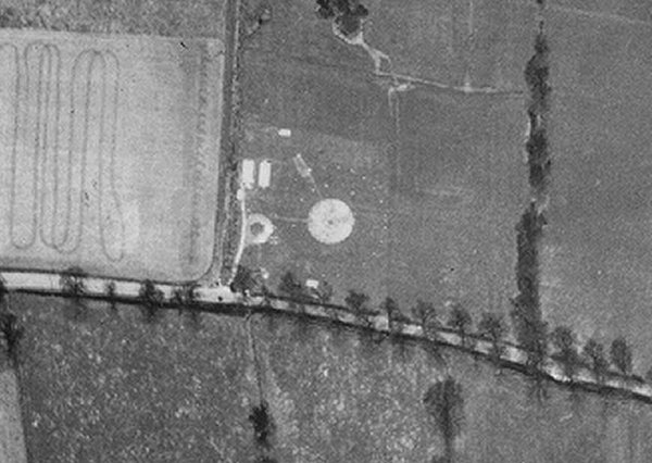
Yeovil Barrage Balloon Site No 2, "Watercombe Road Barford", south of Yeovil Airfield, Westland. A barrage balloon site can e seen on the RAF vertical air photographs of 1946. As well as the circular concrete base three Nissen huts and associated structures can be seen to the east. Three other structures can be seen to the south, close to road that would have been used by the winch lorry. See photograph in gallery below.
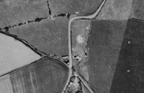
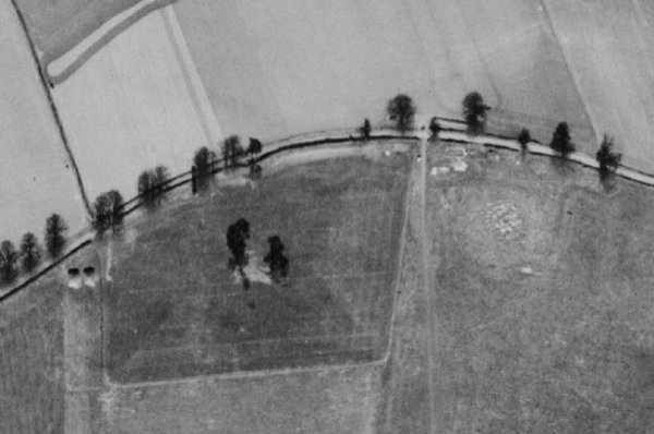
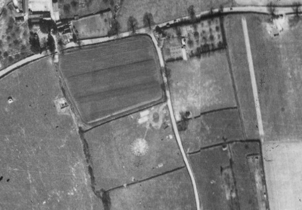
Yeovil Barrage Balloon Site No 3, "Ash Copse Barnford", Ashmead, West Coker. A barrage balloon site can be seen on RAF vertical air photographs of 1946. Two structures can be seen on the west side of the circular concrete base. See photographs in gallery below.
Yeovil Barrage Balloon Site No 4, "Cullivers Grave East Coker", south east of Culliver's Grave, East Coker. A barrage balloon site can be seen on RAF vertical air photographs of 1946. As well as the circular concrete base, three Nissen huts can be seen to the south along with the loop road that was needed for the winching lorry. Further smaller structures can be seen in the vicinity and are probably related.
Yeovil Barrage Balloon Site No 5, "Nash Lane East Coker", south of Placket Lane, East Coker. A barrage balloon site can be seen on the RAF vertical air photographs of 1946. Three Nissen huts can be seen to the north of the circular concrete base.
Yeovil Barrage Balloon Site No 6, "Gunville Lane East Coker", Gunville Lane, East Coker. A barrage balloon site can be seen on the RAF vertical air photographs of 1946. The access road for the winching lorry can be seen to the south east of the circular concrete base and the remains of the associated structures can be seen to the east.
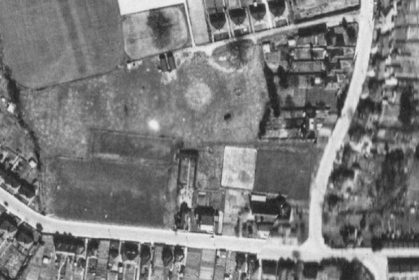
Yeovil Barrage Balloon Site No 7, "Yew Tree Close Hendford Hill", Yew Tree Close, Yeovil. Barrage balloon site visible on RAF vertical air photographs of 1946. The loop road for the lorry can be seen on the east side. A small structure can be seen to the west of the concrete base, three possible further structures can be seen to the south. See photograph in gallery below.
Yeovil Barrage Balloon Site No 8, "Ackmans Farm Yeovil", Yeovil Road, East Coker. A barrage balloon site can be seen on RAF vertical air photographs of 1946. To the south of the circular concrete base a number of possible ancillary buildings can be seen.
Yeovil Barrage Balloon Site No 9, "Linden Road Yeovil", west end of Linden Road, Yeovil. A barrage balloon site is visible on RAF vertical air photographs of 1946. Two Nissen huts are evident to the north west of the circular concrete base, whilst a further structure can be seen to south east. There is also a possible related feature, an earthwork (?) to the east.
Yeovil Barrage Balloon Site No 10, "Horsey Lane", to the rear of 129-143 West Hendford, Yeovil. Barrage Balloon site visible on RAF vertical air photographs of 1946. There is a possible related structure to the north of the concrete circular base. See photograph in gallery below.
Yeovil Barrage Balloon Site No 11, "Aldon Farm Dorchester Road", east of Lover's Lane, Yeovil. A possible circular concrete base of a barrage balloon site can be seen on the RAF vertical air photographs of 1946. Concrete tethering blocks still remain beside the lane leading to Aldon (see Gallery).
Yeovil Barrage Balloon Site No 12, "Dunnocks Lane", west of Keyford Roundabout, East Coker. Barrage Balloon site visible on RAF vertical air photographs of 1946. The circular concrete base is visible as well as some possible ancillary buildings located to the north. To the south there is a possible related linear feature.
Yeovil Barrage Balloon Site No 13, "Two Towers Lane", Two Tower Lane, Barwick. A Barrage Balloon site can be seen on RAF vertical air photographs of 1946. The remains consist of a circular concrete base and some related structures to the north.
Yeovil Barrage Balloon Site No 14, "Windmill Hill" (today's Wyndham Hill), south east of Ivel Court, Yeovil. A barrage balloon site can be seen on the RAF vertical air photographs of 1946. Associated structures seem to have been located to the west of the circular concrete base. See photograph in gallery below.
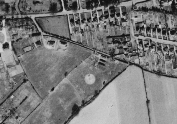
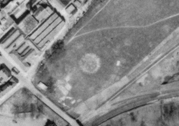
Yeovil Barrage Balloon Site No 15, "Higher Kingston Rec. Ground", Kingston View, Yeovil. Recreation Ground (actually Bide's Gardens), Yeovil. A Barrage Balloon site can be seen on RAF vertical air photographs of 1946. Traces of the circular concrete base can be seen in the centre of the site and the remains of associated structures to the east. See photograph in gallery below.
Yeovil Barrage Balloon Site No 16, "Westland Aircraft Factory", Westland Aircraft Factory, Yeovil. No trace of the circular concrete base can be seen on the RAF vertical air photographs of 1946, although there are traces of the loop road used by the winch lorry and some Nissen huts.
Yeovil Barrage Balloon Site No 17, "Coronation Avenue Larkhill", 142-48 Thatcham Park, Yeovil. A barrage balloon site is visible on RAF vertical air photographs of 1946. To the south of the concrete circular base two Nissen huts can be seen. A further structure can be seen to the north west.
Yeovil Barrage Balloon Site No 18, "Westland Aircraft Company", 190m north northeast of Kingfisher Close, Yeovil. A barrage balloon site can be seen on RAF vertical air photographs of 1946. Related structures can be seen to the south east.
Yeovil Barrage Balloon Site No 19, "Larkhill Lane", Larkhill Lane, Yeovil. There are no traces of any structures on the RAF vertical air photographs of 1946, but it is quite clear on the 1941 photograph shown in the gallery below.
Yeovil Barrage Balloon Site No 20, "Yeovil Bacon Company", Stratford Road, Yeovil. A barrage balloon site can be seen on the RAF vertical air photographs of 1946 to the immediate north east of the Preston Plucknett Bacon Factory. As well as the circular concrete base two Nissen huts can be seen to the south east and other possibly related structures. The remains of the loop road that the winch lorry would have used can be seen to the west.
Yeovil Barrage Balloon Site No 21, "Morsey Lane, Yeovil", Stourton Way, Brympton. A barrage balloon site can be seen on the RAF vertical air photographs of 1946. The remains of the circular concrete base can be seen as well as associated structures to the west.
Yeovil Barrage Balloon Site No 22, "Preston Road Yeovil", Houndstone Retail Park, Yeovil. A barrage balloon site can be seen on the RAF vertical air photographs of 1946. As well as the circular concrete base, two Nissen huts can be seen to the north west. The loop road for the winching lorry can also be seen to the west. See photograph in the gallery below.
Yeovil Barrage Balloon Site No 23, "Alvington Road", Bluebell Road, Brympton. A barrage balloon site can be seen on the RAF vertical air photographs of 1946. To the north of the circular concrete base can be seen the remains of the loop road for the winching lorry as well as the site of related structures.
Yeovil Barrage Balloon Site No 24, "Rex Road Brympton", north east of Brympton House, Brympton. A barrage balloon site can be seen on the RAF vertical air photographs of 1946. Two Nissen huts can be seen to the south west. (see Gallery).
Yeovil Barrage Balloon Site, west of Summerhouse Hill, Yeovil. A searchlight site is listed in the 1941 list of searchlights in the Public Record Office but not in the 1943 list. Balloon site No 16 "Allotments" listed at ST 5578 1547 in Searchlight Cluster List dated 1 Aug 1941. There is nothing visible at the given grid reference on RAF photographs of 1946 but a little to the west appear to be 2 hut bases which may be the site.
The above listings are from the Somerset Historic Environment Record.
|
An
Evacuee
to
Yeovil
remembers
.... "I saw a British aircraft, not a Lysander, hit a barrage balloon cable which took off the end of its wing and it just twisted round and round to the ground out of sight and then I heard a bang followed by a column of smoke. I don’t know what happened to the airman." |
map
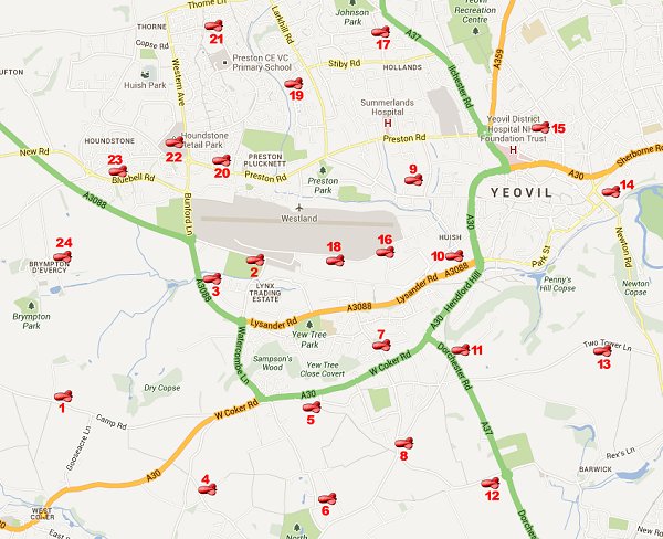
Map showing the
location of
Yeovil's barrage
balloon sites.
The numbers
correspond to
the numbering in
the text above.
The balloon
icons mark the
positions of the
sites, not the
numbers.
Courtesy of
Yeovil Library
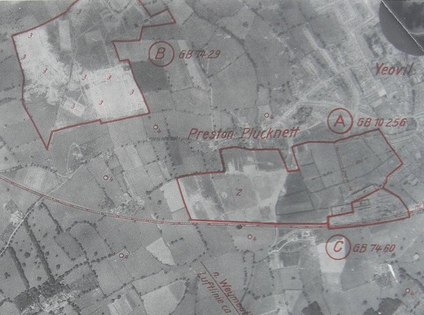
This is part of a German reconnaissance photograph of the Second World War highlighting the targets of Westland's Airfield (marked 'A'), a temporary army camp (marked 'B') and the Westland factory (marked 'C'). Within 'A' are three aircraft hangers marked '1' in the lower right corner and the airfield itself is marked '2' - note how the airfield has been camouflaged by pouring oil on the grass to create the appearance of hedges around small fields. Within 'B' are several barracks huts, each marked '3'. Dotted around the map and marked '4' are several sites of 'Fesselballons' or barrage balloon sites.
gallery

This photograph
features in my
books 'Secret
Yeovil'
and
"Yeovil,
the Home
Front,
1939-1945"
A barrage balloon flies over Yeovil. It should be noted that it was illegal to photograph military installations during the war.
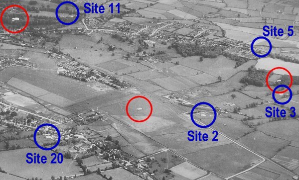
An aerial photograph of Westlands taken in 1941 with three barrage balloons circled in red and Barrage Balloon Sites circled in blue.

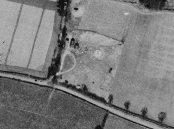
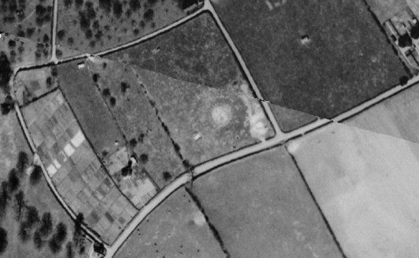
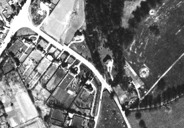
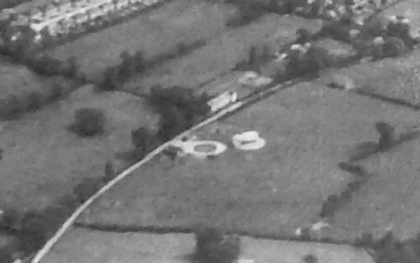
From the same 1941 photograph - this is an enlargement from the circled balloon at right, here shown just right of centre of the photograph, is Yeovil Barrage Balloon Site No 3, "Ash Copse Barnford" (ie Bunford Hollow). The balloon appears to be only just launching from the ground and its launch site is seen immediately below it. West Coker Road runs across the top of the photograph.
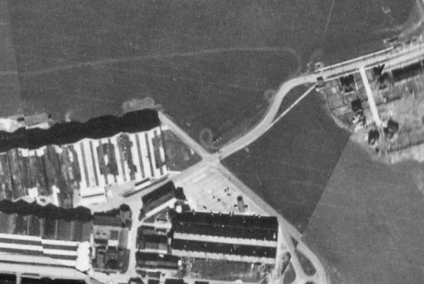
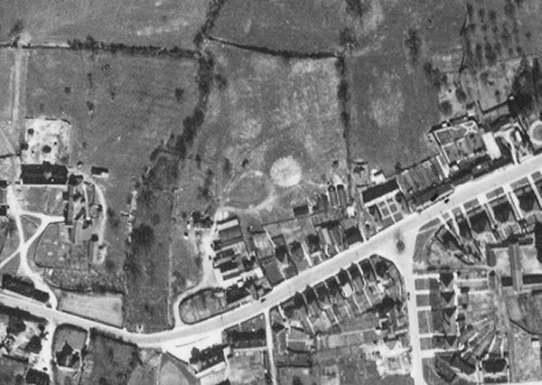
In the bottom left corner is the edge of Westland's airfield together with, in what appears to be a circular road, Yeovil Barrage Balloon Site No 2, "Watercombe Road Barford" (ie Bunford) adjacent to the Bunford Flax Factory - built in 1916 to supply linen for covering the wings, etc. of aircraft being produced in the Westland factory off photo to the left.
Yeovil Barrage Balloon Site No 1, "Camp Road West Coker", south of Leaze Plantation, West Coker. A barrage balloon site can be seen on the RAF vertical air photographs of 1946. As well as the circular concrete base three Nissen huts and the loop road for the winching lorry can be seen to the west.
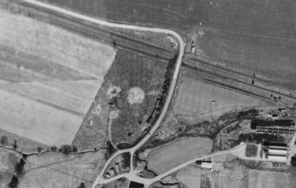
Yeovil Barrage Balloon Site No 2, "Watercombe Road Barford" (ie Bunford), south of Westland Airfield. A barrage balloon site can be seen at the centre, as well as the circular concrete base three Nissen huts and associated structures can be seen to the east. Three other structures can be seen to the south, close to road that would have been used by the winch lorry.

Courtesy of Jack
Sweet.
This
colourised photograph
features in
my 2024 book "Yeovil,
the Home
Front,
1939-1945"
The Women's Auxiliary Air Force (WAAF) who staffed the Yeovil Barrage Balloon Site No 2, "Watercombe Road Barford" (ie Bunford).
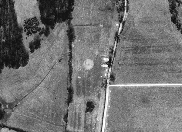
Yeovil Barrage Balloon Site No 3, "Ash Copse Barnford" (ie Bunford Hollow) seen in the 1946 aerial survey (I've turned the photograph such that north is 'down' so that it more readily ties in with the previous photograph).
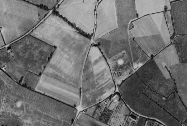
With the West Coker Road in the top left quadrant, Yeovil Barrage Balloon Site No 4, "Culliver's Grave East Coker", south east of Culliver's Grave, East Coker, is just right of centre. As well as the circular concrete base, three Nissen huts can be seen to the south along with the loop road that was needed for the winching lorry. Further smaller structures can be seen in the vicinity and are probably related.
With the West Coker Road running across the top of this photograph and Placket Lane running from top left to centre right, Yeovil Barrage Balloon Site No 5, "Nash Lane East Coker", south of Placket Lane, is seen at the centre. Three Nissen huts can be seen to the north of the circular concrete base.
Yeovil Barrage Balloon Site No 6, "Gunville Lane East Coker", with the road to North Coker running from top right to bottom left, Gunville Lane running to top centre and Longlands Lane running from bottom left to top left then turning east to meet Gunville Lane. The barrage balloon site can be seen at the centre. The access road for the winching lorry was to the south east of the circular concrete base and the remains of the associated structures can be seen to the east.
Yeovil Barrage Balloon Site No 7, "Yew Tree Close, Hendford Hill", visible on the RAF vertical air photograph of 1946. The loop road for the lorry can be seen on the east side. West Coker Road runs across the bottom right corner of the photograph.
Yeovil Barrage Balloon Site No 8, "Ackmans Farm Yeovil", Yeovil Road, East Coker. To the south of the circular concrete base a number of possible ancillary buildings can be seen.
Preston Grove runs along the bottom of the photograph and Grove Avenue snakes its way up the right side. Yeovil Barrage Balloon Site No 9, "Linden Road Yeovil" is sited at the west end of Linden Road, seen at the top. Two Nissen huts are evident to the north west of the circular concrete base, whilst a further structure can be seen to south east. There is also a possible related feature, an earthwork (?) to the east. The site is now a sports field.
Yeovil Barrage Balloon Site No 10, "Horsey Lane", to the rear of 129-143 West Hendford seen on the RAF vertical air photographs of 1946. There is a possible related structure to the east of the concrete circular base that look like two Nissen huts. West Hendford (at this time just a track beyond Horsey Lane) runs diagonally from right of centre at top to bottom left while Horsey Lane runs diagonally across the top right.
With the West Coker Road in the top left corner and the Dorchester Road running from top left towards bottom right. At right centre is Yeovil Barrage Balloon Site No 11, "Aldon Farm Dorchester Road", lying between Lover's Lane to the left and the access road to Aldon to the right. A possible circular concrete base of a barrage balloon site can be seen on the RAF vertical air photographs of 1946. Concrete tethering blocks still remain beside the lane leading to Aldon.
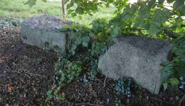
Concrete tethering blocks remain beside the lane leading to Aldon - Yeovil Barrage Balloon Site No 11, "Aldon Farm Dorchester Road"
This
photograph
features in
my 2024 book "Yeovil,
the Home
Front,
1939-1945"
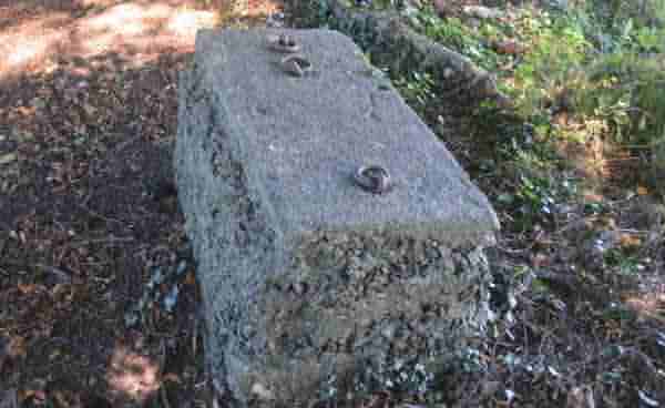
... and another of the Aldon tethering blocks, showing the metal rings cast into the concrete.
The Dorchester Road is in the top right quadrant with the Red House junction (now the massive Keyford roundabout). At centre is Yeovil Barrage Balloon Site No 12, "Dunnocks Lane". The circular concrete base is visible as well as some possible ancillary buildings located to the north. To the south there is a possible related linear feature.
Two Tower Lane runs across this photograph with the Fish Tower at centre left and Yeovil Barrage Balloon Site No 13, "Two Towers Lane" at centre right. The remains consist of a circular concrete base and some related structures to the north.
Yeovil Barrage Balloon Site No 14, "Windmill Hill" (today's Wyndham Hill), seen on the RAF vertical air photograph of 1946. Associated structures seem to have been located to the west of the circular concrete base. Newton Road runs diagonally across the bottom left corner and the railway line is seen at bottom right.

Courtesy of Rob
Baker.
This
colourised photograph
features in
my 2024 book "Yeovil,
the Home
Front,
1939-1945"
The balloon of Yeovil Barrage Balloon Site No 14, "Windmill Hill" (today's Wyndham Hill), The photo was taken from 200 Sherborne Road, by Dennis Wood who captioned the balloon "Barry".
Yeovil Barrage Balloon Site No 15, "Higher Kingston Rec. Ground" (actually Bide's Gardens), is seen at centre on this RAF vertical air photograph of 1946, immediately east of the hospital. Higher Kingston runs from top left to centre right where it continues as Reckleford at the junction with The Avenue (top right) and Court Ash Terrace (lower right).
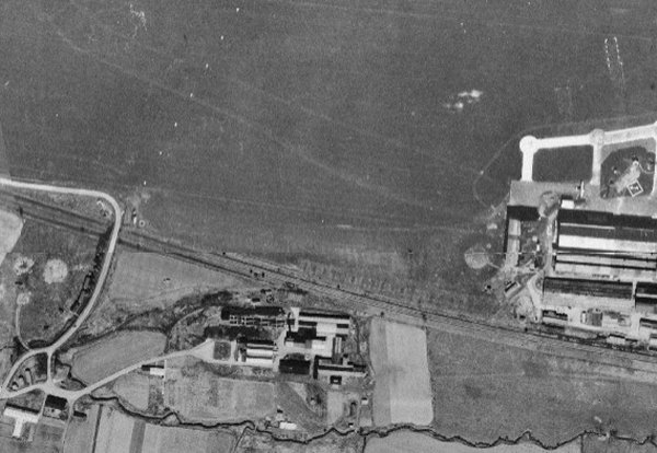
With the Westland airfield at the top of this photograph and the factory buildings occupying the lower left quadrant, the remains of Yeovil Barrage Balloon Site No 16, "Westland Aircraft Factory" are at the very centre. No trace of the circular concrete base can be seen, although there are traces of the loop road used by the winch lorry and some Nissen huts.
Yeovil Barrage Balloon Site No 17, "Coronation Avenue, Larkhill" seen at centre on the RAF vertical air photograph of 1946. To the south of the concrete circular base two Nissen huts can be seen. A further structure can be seen to the north west. Coronation Avenue runs up the left of this poorly stitched set of maps while Ilchester Road runs diagonally across the top right.
Westland airfield occupies the top of this photograph with the start of the Westland factory buildings at centre right. To the immediate west of the factory buildings is Yeovil Barrage Balloon Site No 18, "Westland Aircraft Company". Related structures can be seen to the south east.
At centre left is Yeovil Barrage Balloon Site No 2, "Watercombe Road Barford" (ie Bunford).
From the same 1941 aerial photograph as above - Westland's airfield is seen at top right while at bottom left is Yeovil Barrage Balloon Site No 19, "Larkhill Lane, Yeovil".
An enlargement of the previous 1941 aerial photograph showing Yeovil Barrage Balloon Site No 19, "Larkhill Lane, Yeovil".
Yeovil Barrage Balloon Site No 20, "Yeovil Bacon Company", Stratford Road, seen on the RAF vertical air photographs of 1946. As well as the circular concrete base two Nissen huts can be seen to the south east and other possibly related structures. The remains of the loop road that the winch lorry would have used can be seen to the west. The east-west road running across the photograph is Preston Road.
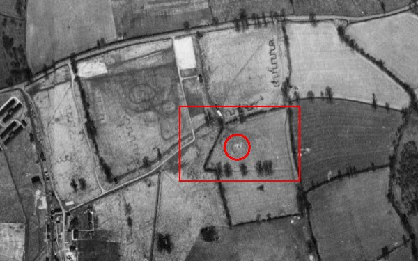
Yeovil Barrage Balloon Site No 21, "Morsey Lane, Yeovil", Stourton Way, Brympton - circled in red within the red rectangle shown enlarged below. The remains of the circular concrete base can be seen as well as associated structures to the west.
Lufton and Houndstone army camps were off to the left and much of this area was used for training - see, for example the numerous zigzag practice trenches.
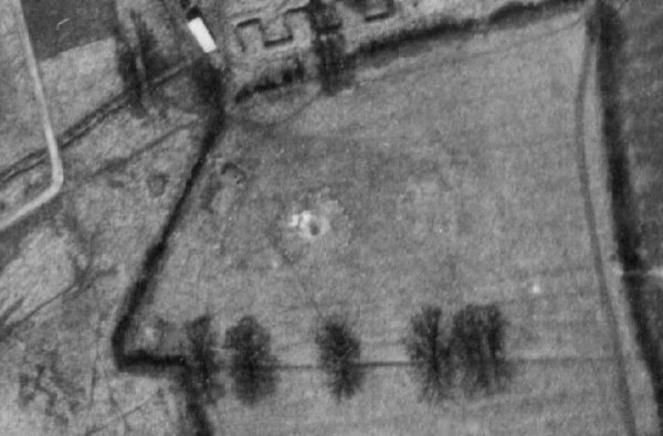
Yeovil Barrage Balloon Site No 21, "Morsey Lane, Yeovil", enlarged section of the previous photograph, showing the remains of the circular concrete base and associated structures to the west.
Yeovil Barrage Balloon Site No 22, "Preston Road Yeovil" as seen in the aerial photograph of 1946. The site is now under the Houndstone Retail Park but Preston Road is seen running across the photograph and the hedgerow running from Preston Road to the top of the photo at right is the approximate line of today's Western Avenue.
A track leads from Preston Road to the circular loop road for the winching lorry, the track then continues towards two Nissen huts. The circular concrete base is seen to be surrounded by two rings of concrete blocks - these were mooring blocks used to tether the balloon.
Another section of the 1941 aerial photograph featured above but this part shows Preston Road running from top left to the bottom right corner and towards bottom right is Yeovil Barrage Balloon Site No 22, "Preston Road Yeovil" while at top centre is its balloon (the centre of the three circled in the photograph above).
Yeovil Barrage Balloon Site No 23, "Alvington Road" seen at lower centre on the RAF vertical air photograph of 1946. To the north of the circular concrete base can be seen the remains of the loop road for the winching lorry as well as the site of related structures. Bluebell Road runs along the top of the photograph while Alvington Lane runs vertically at centre.
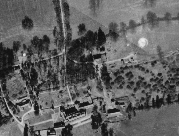
Yeovil Barrage Balloon Site No 24, "Rex Road, Brympton". The barrage balloon site can be seen in the top right quadrant of this photograph and its two associated Nissen huts can be seen to the south west. Brympton House itself is at the bottom centre.

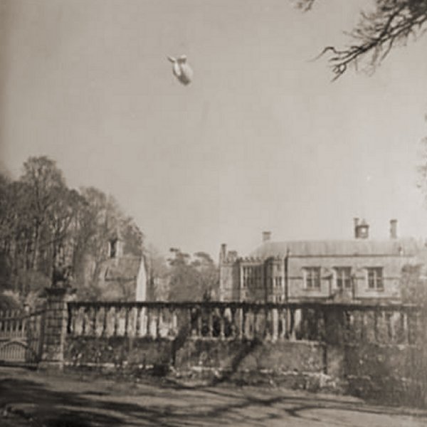
This
colourised photograph
features in
my 2024 book "Yeovil,
the Home
Front,
1939-1945"
The barrage balloon rises over Brympton House from Yeovil Barrage Balloon Site No 24, "Rex Road Brympton".
... and rises higher in this second shot.
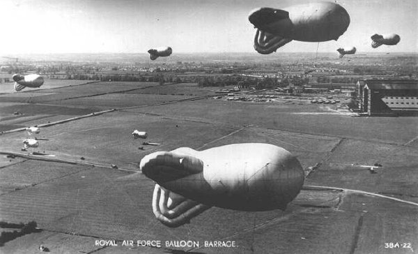
A famous postcard showing a typical balloon barrage.