Corner Close
Corner Close
At the corner of West Coker Road and Dorchester Road
Corner Close was a large D-shaped field bounded by West Coker Road to the north, Dorchester Road and East Coker Road to the east and Hoopers Lower Field (Parcel 727) to the west. The name clearly derives from its position at the junction, or corner, of West Coker Road and Dorchester Road.
A group of late Roman coarse pottery similar to that from the Westland Roman complex to the north was discovered in the field. The pottery is in the Community Heritage Access Centre. The site was investigated by Alderman, later Mayor, William RE Mitchelmore who uncovered part of a circular wall of a hut. At the time the area was under pasture with no surface indications of any structure. The area is now built on.
It is most likely that Corner Close was the site of burials of suicides, at least until the early nineteenth century. In its edition of 9 May 1814 the Sherborne Journal reported "A girl of the name of Sherstone, 20 years of age, servant to Mr Isaac Mullins, farmer of Yeovil (actually a glove manufacturer) put a period to her existence on Monday morning last, by taking a portion of arsenic; the Coroner's Jury sat on Saturday on the body, and brought in their verdict 'felo de se' (felon of himself). She was buried at the Cross Roads near the town. No cause is assigned for her committing this rash act, except a notice from her employer to quit his service for inattention to his afflicted mother."
In 'Young Thomas Hardy' by Robert Gittings the story is recalled of a tale told to Thomas Hardy by his mother Jemima Hardy "She told him about a girl who had committed suicide, and whose burial she remembered as an event in her childhood. The girl was buried on Hendford Hill, near Yeovil, at a cross-roads on a bleak hill-top. Few followed to her unblessed grave. There was no coffin to carry her, and no wreath, though one other girl threw flowers on the exposed body. When it was put into the grave, a stake was driven through it, before the earth was heaped up over her, sloping up the sides of the stake like a prehistoric tumulus." People who committed suicide were often buried at this crossroads at the top of Lovers' Lane.
Another such place of interment was Noble's Nap.
In its edition of 5 January 1753, the Derby Mercury reported; "Last Saturday sen'night one John Adams, of Yeovil, in the County of Somerset, was found hanging in a Stable at the Sign of the Crooked Fish at Frome... ordered to be buried in the common Highway, and to have [a] Stake drove through [his] Body."
An Act of 4 George IV (1823) directed that for the future a felo de se may be buried in the unconsecrated portion of a churchyard between the hours of nine and twelve at night and expressly states "without any stake being driven through the body". The driving of a stake through the body of a felon or suicide, was to prevent the ghost from "rising to the face of the earth again."
The
1846 Tithe
Apportionment
described Corner
Close (Parcel
728) as
arable and
measuring 8a 2r
0p and noted
that draper and
grocer
John Glyde
was the owner
and it was
occupied by
Lionel Harrison,
a sailcloth
weaver of East
Coker.
As seen in the
aerial
photograph of
1946 below,
Corner Close had
been built on by
this time with a
run of large
houses on the
Dorchester Road
side and their
gardens
occupying the
remainder of the
former field, as it
remains today.
MAPs & Aerial Photographs
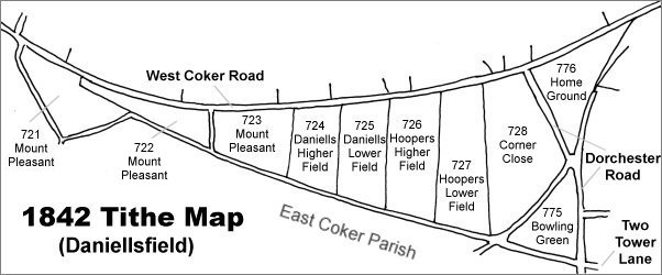
Map based on the 1842 Tithe Map with field names added from the 1846 Tithe Award. Corner Close is at centre right.
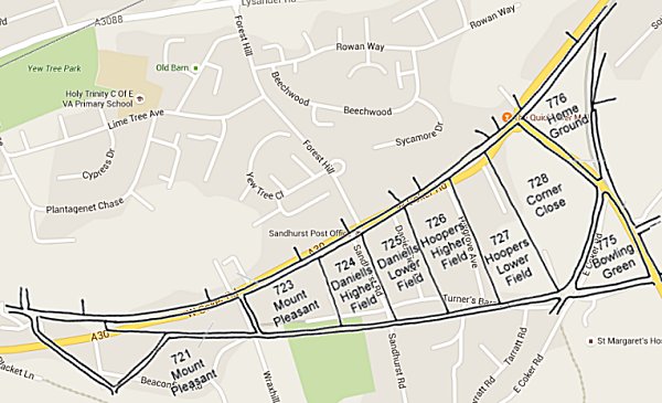
The 1842 Tithe Map superimposed over a modern map of the area. Although the field boundaries do not align precisely, remember that the 1849 survey was undertaken by hand using primitive surveying equipment.
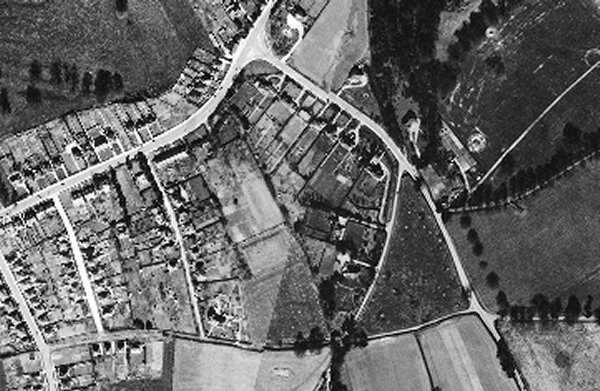
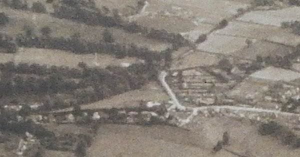
The 1946 aerial photograph with West Coker Road running from centre left to centre top and Dorchester Road running from top centre down to bottom right of centre. Corner Close is at centre.
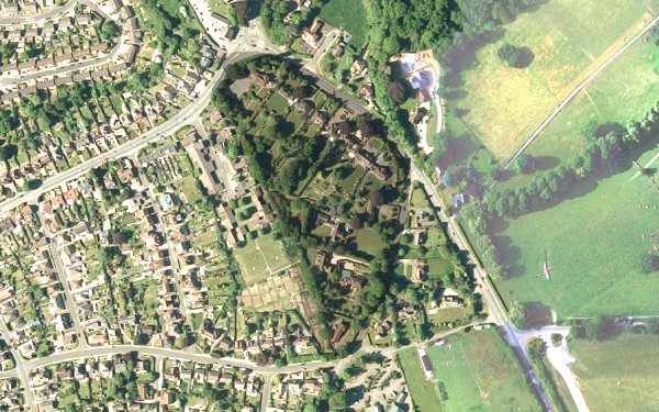
The modern satellite image clearly shows the 'footprint' of the former D-shaped Corner Close as the area at centre bounded for most of its perimeter by large trees. The rest of the image has been lightened to make Corner Close stand out.
This is an aerial photograph taken in 1941 and looking south. West Coker Road runs across the width of the lower part of the photograph and Dorchester Road is seen at right of centre running up and across towards top right. The former Corner Close is seen right of centre, already built up at this time.