higher larkhill
higher larkhill
A former part of the great West Field of Kingston Manor
Larkhill, or Great Larkhill, was originally a sub-field, probably a common field, within the great medieval West Field of Kingston Manor. By the end of the eighteenth century it had been broken up into several smaller parcels of which Higher Larkhill was one.
A lease dated 28 September 1814 between John Daniell of Yeovil, Esq., and George Bragge Prowse of Yeovil, Esq., refers to the lease of ".... pasture (called) Higher Larkhill 6a, pasture x 2- Caymes Larkhill and Daniell’s Lower Larkhill 7a, a lane called Larkhill Lane leading from the Turnpike Road to Higher Larkhill containing ¾a. All in the Parish of Yeovil late in possession of Samuel Daniell Dec’d ."
In her will dated 4 December 1817, Mary Coward formerly Strong, wife of grocer George Coward, wrote "I give and devise unto my loving Husband the said Henry Coward my two Closes of Land called Higher Lark Hill and Lower Lark Hill in Yeovil aforesaid containing about seventeen Acres (purchased in fee by the late Samuel Strong) of Messiors Glyde and Watts and given to me by my late Uncle Richard Strong his Heirs and Assigns...".
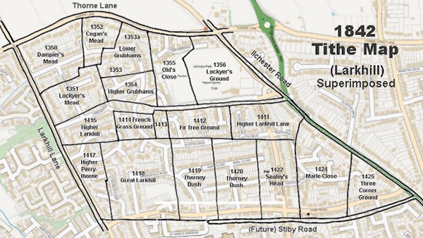
Higher Larkhill (Parcel 1415) was a field of Larkhill Farm and was bounded to the west by Larkhill Lane, to the north by Lockyer's Mead (1351) and Higher Grubhams (1354), to the east by French Grass Ground (1414) and to the south by Higher Perrythorne (1417) and Great Larkhill (1418). At its northeast corner the field extended as a wide field access track until it joined with Higher Larkhill Lane - now developed as Boundary Close.
The 1846 Tithe Apportionment recorded Higher Larkhill as 8a 2r 2p and noted its use as pasture for grazing livestock. The Apportionment noted that the owner of Higher Larkhill was William Jones Prowse and the tenant was James Pope.
Today the site of the former Higher Larkhill is occupied by the houses and gardens of Larkhill Road, the western end of Greenwood Road and the northern spur of Larkspur Crescent.
For details on historic land measurement (ie acres, roods and perches) click here.
maps

This map, based on the descriptions in the 1589 Terrier and the 1846 Tithe Map of Yeovil shows the approximate boundaries of the Manors of Kingston and Hendford as well as the manorial three-field system used in Kingston.
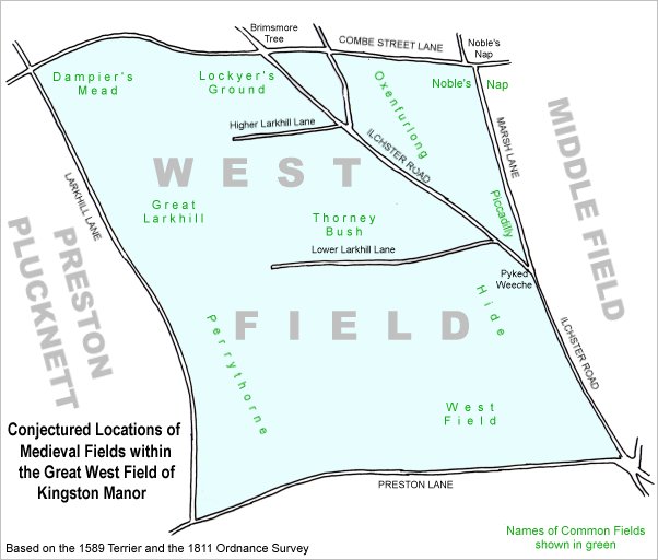
A conjectural map of the great West Field of Kingston Manor showing ancient sub-fields, most likely common fields, within the overall bounds of West Field.
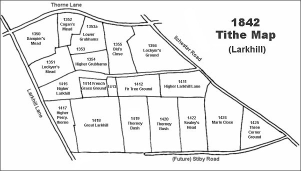
The Larkhill area reproduced from the 1842 Tithe Map. Dampier's Mead is top left.
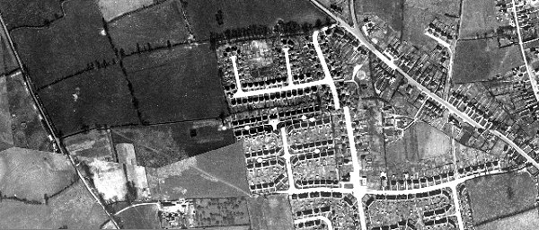
The 1946 aerial photograph showing Higher Larkhill at centre left. By this time the spur of Higher Larkhill running across the top of French Grass Ground had been absorbed into French Grass Ground but the outline of the spur is still visible as a mark across the latter field. Coronation Avenue appears to have been hit by an earthquake but it is just a poor alignment of the original aerial photographs.
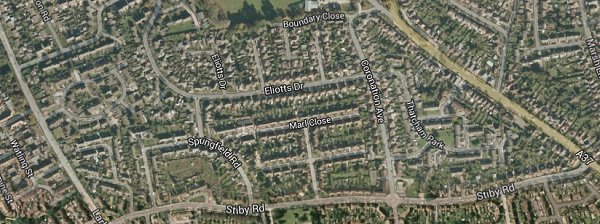
The same area today 'borrowed' from Google maps.
The 1842 Tithe Map superimposed (slightly out at the bottom) over a modern map.