marle close
marle close
A field within a field
Note: The field
under discussion here
was Parcels 998
and 998a, to the
north of today's
Grass Royal.
This is
not the
field called
Marle Close
(Parcel 1424)
originally near
the junction of
today's Stiby
Road and
Ilchester Road.
![]()
Marl was originally an old term loosely applied to a variety of materials, most of which occur as loose, earthy deposits consisting chiefly of a mixture of clay and calcium carbonate. It has been used as a soil conditioner and acid soil neutralising agent and was spread on sandy soil by the Celts before the Roman occupation. Its value was realised, and its use revived, by the 'improvers' of the seventeenth and eighteenth centuries.
On the other hand, Marl was also an ancient term used to describe human waste and remote areas of sunken ground were used as a dumping ground and designated as 'marl pits'.
Marle Close was a field, later divided into two Parcels (998 and 998a) that was, essentially, carved out of the larger field Higher Ryalls (999 and 1005) that ultimately bounded it on its north, east and south sides. The west boundary was with Lower Ryalls (995 & 996).
An indenture in my collection dated 8 April 1806 shows Samuel Isaac to have leased two fields from John Newman of Barwick for five shillings a year.
In his will of 1828 William Row stated ".... All that Close of Pasture Ground called Marle Close containing by estimation six acres purchased of Mr Samuel Isaac.... " but it seems that by the 1840s Samuel Isaac owned both fields again. The land in question was "All those two closes of Meadow or Pasture Ground called East Ryalls and West Ryalls otherwise East Royals and West Royals containing by Estimation Fifteen Acres (be the same more or less) bounded on the East by the Highway (today's St Michael's Avenue) leading from Gore Knapp to a place called Newman's plot and on the West by Ryalls Lane (today's Eastland Road) situate lying and being in the parish of Yeovil aforesaid and now or late in the occupation of Thomas Bullock as Tenant thereof to the said John Newman and which said Lands were formerly the Inheritance of John Newman Deceased Grandfather of the said John Newman party hereto and on his decease descended unto his Eldest Son John Newman Father of the said John Newman party hereto and were in and by the last Will and Testament of the said John Newman the son devised unto the said John Newman party hereto in Fee Simple....".
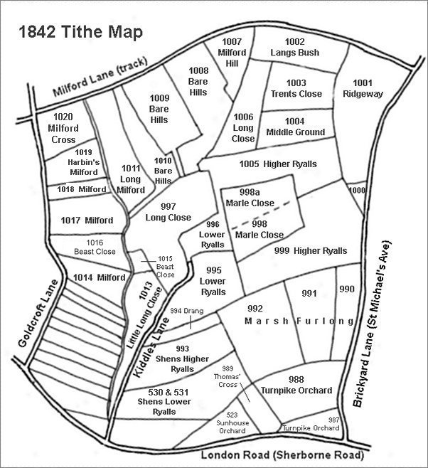
By the time of the 1842 Tithe Map these two fields had been subdivided into the following parcels -
West Ryalls
divided into -
995 Lower Ryalls - leased to Charles Marsh
996 Lower Ryalls - sold to Ann Collins
East Ryalls
divided into -
998 In Marle Close - sold to John Tanner Whiteley Pitcher
999 Higher Ryalls - leased to Charles Marsh
1005 Higher
Ryalls -
sold to Ann
Collins
The 1846 Tithe Apportionment noted that the area of Marle Close was 1a 3r 4p (998) and 2a 2r 0p (998a). Both Parcels were used as pasture for grazing livestock. It was owned by John Tanner Whiteley Pitcher and occupied by George Prinn.
Samuel Isaac died in 1849 and his fields passed to his brother Thomas who sold them off within six months.
Therefore, from the above, owners of East Ryalls / Higher Ryalls were -
John Newman of
Barwick (c1680 -
bef1790) owner
John Newman of
Barwick
(1717-1799)
owner
John Newman of
Barwick
(c1773-1855)
owner, Thomas
Bullock tenant
Samuel Isaac
(1783-1849)
lessee then
owner
divided into three parcels during this ownership
Parcel 998 - John Tanner Whiteley Pitcher owner,
George Prinn
tenant
Parcel 999 - Samuel Isaac owner, Charles Marsh
tenant
Parcel 1005 - Ann Collins owner, James Squire
tenant
Today the former Marle Close is occupied by the houses and gardens of Fielding Road and the very northernmost part of Royal Close.
maps

This map, based on the descriptions in the 1589 Terrier and the 1846 Tithe Map of Yeovil shows the approximate boundaries of the Manors of Kingston and Hendford as well as the manorial three-field system used in Kingston.
This map is based on the 1842 Tithe Map with field names added from the 1846 Tithe Award.
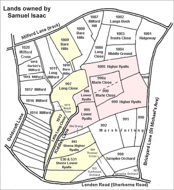
The area shaded pink are the former East Ryalls and West Ryalls leased in 1806, but later owned by, Samuel Isaac. The areas shaded yellow are other parcels owned by him although by 1842 he had sold off Parcels 996 and 1005 to Ann Collins and Parcels 998 and 998a to John Tanner Whiteley Pitcher. Samuel Isaac also owned several other parcels outside this map.
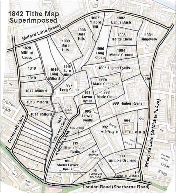
The 1842 Tithe Map superimposed (roughly) over a modern street map showing where several modern roads, for example Gordon Road, Grass Royal and Highfield Road, follow former field boundaries.
Gallery
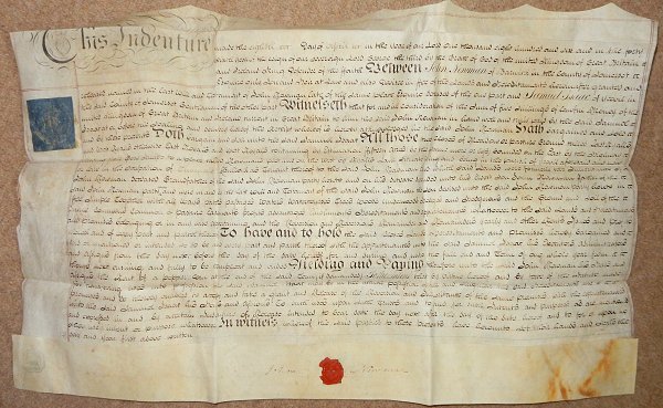
From my
collection
An indenture dated 8 April 1806 in which Samuel Isaac leases East and West Ryalls from John Newman Esq of Barwick. By the 1840s Samuel owned the land outright.