higher ryalls
higher ryalls
A field in the great Middle Field
Eastland Road has been around, primarily nothing more than a field access track in the lower part of Kingston Manor's Middle Field, for centuries but has only recently acquired its present name. Between the 1760s and the 1790s wealthy glove manufacturer John Ryall had a glove factory in the area and the lane was known as Ryall's Lane and is shown as such on Watt's map of 1806. By the time of the 1841 census the lane was known as Kiddle's Lane after glove manufacturers John and William Kiddle who were active in the 1840s and 1850s. The field names of both Higher and Lower Ryalls are clearly based on the Ryall family name but were also known as 'Royal'.
The 1590 Terrier showing Middle Field refers to ".... Alice Haines and John Francis Closes upon Ryalls...." and also makes reference to ".... Wm Jennings in Ryalls....". The 1633 Survey of Kingston recorded that John Symes held "two tenements, 2 half tenements, a cottage and barn, 2 gardens, 3 orchards 8 acres, 2 closes of pasture 14 aces, one of which is called Ryalles."
In his will dated 15 March 1725, John Jeanes wrote "... I give devise and bequeath the same to my Nephews Thomas Burford of [word illegible] Clerke Office in the County of Middlesex Gentleman and John Burford one of the Fellows of Kings Colledge in Cambridge Gentleman and their heires dureing the naturall life of my daughter Mary together with one ground called Milford and two acres in Gold Croft One acre in Goare feild and Yeovill Bridge Mead together with all those foure peices of ground called Ryalls in the parish of Yeovill aforesaid In trust to apply and dispose of the rents issues and profitts thereof to the proper hands of my said daughter or as she shall appoint ...".
In his will of 1753, Yeovil butcher Thomas Francis wrote "I give devise and bequeath all those three Closes called Ryalls which I lately purchased of George Davy situate lying and being in Yeovil aforesaid unto my Son Thomas Francis and his Heirs and Assigns for ever".
E Watts map of 1806 shows Ryall's Yard in Ryalls Lane.
Higher Ryalls had previously been called East Ryalls or East Royals.
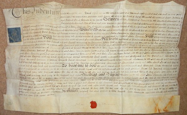
An indenture in my collection dated 8 April 1806 shows Samuel Isaac to have leased two fields from John Newman of Barwick for five shillings a year. By the 1840s Samuel Isaac owned both fields. The land in question was "All those two closes of Meadow or Pasture Ground called East Ryalls and West Ryalls otherwise East Royals and West Royals containing by Estimation Fifteen Acres (be the same more or less) bounded on the East by the Highway (today's St Michael's Avenue) leading from Gore Knapp to a place called Newman's plot and on the West by Ryalls Lane (today's Eastland Road) situate lying and being in the parish of Yeovil aforesaid and now or late in the occupation of Thomas Bullock as Tenant thereof to the said John Newman and which said Lands were formerly the Inheritance of John Newman Deceased Grandfather of the said John Newman party hereto and on his decease descended unto his Eldest Son John Newman Father of the said John Newman party hereto and were in and by the last Will and Testament of the said John Newman the son devised unto the said John Newman party hereto in Fee Simple....".
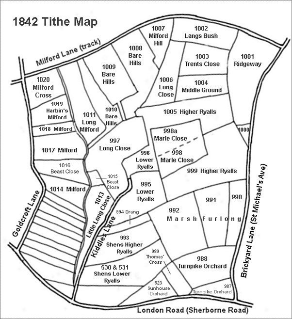
By the time of the 1842 Tithe Map these two fields had been subdivided into the following parcels -
West Ryalls
divided into -
995 Lower Ryalls - leased to Charles Marsh
996 Lower Ryalls - sold to Ann Collins
East Ryalls
divided into -
998 In Marle Close - sold to John Tanner Whiteley Pitcher
999 Higher Ryalls - leased to Charles Marsh
1005 Higher
Ryalls -
sold to
Ann
Collins
By the time of the 1842 Tithe Map, Higher Ryalls had been split into two large fields (Parcels 999 and 1003) and half of the centre of the field had been sub-divided into two further small fields called Marle Close (Parcels 998 and 998a). The 1846 Tithe Apportionment notes both parcels of Higher Ryalls as pasture (that is, grazing land for cattle, horses, etc.).
Samuel Isaac died in 1849 and his fields passed to his brother Thomas who sold them off within six months.
Therefore, from the above, owners of East Ryalls / Higher Ryalls were -
John Newman of
Barwick (c1680 -
bef1790) owner
John Newman of
Barwick
(1717-1799)
owner
John Newman of
Barwick
(c1773-1855)
owner, Thomas
Bullock tenant
Samuel Isaac
(1783-1849)
lessee then
owner
divided into three parcels during this ownership
Parcel 998 - John Tanner Whiteley Pitcher owner,
George Prinn
tenant
Parcel 999 - Samuel Isaac owner, Charles Marsh
tenant
Sold by Samuel's
brother Thomas
on the death of
Samuel.
Parcel 1005 - Ann Collins owner, James Squire
tenant
In the late nineteenth century Grass Royal, clearly employing the field name of Ryall / Royal, was built along the southern boundary of Higher Ryalls and later Highfield Road was built along the northern boundary of Higher Ryalls with Hillcrest Road running across the former Higher Ryalls along the eastern boundary of Marle Close (Parcels 998 and 998a).
maps

This map, based on the descriptions in the 1589 Terrier and the 1846 Tithe Map of Yeovil shows the approximate boundaries of the Manors of Kingston and Hendford as well as the manorial three-field system used in Kingston.
This map is based on the 1842 Tithe Map with field names added from the 1846 Tithe Award.
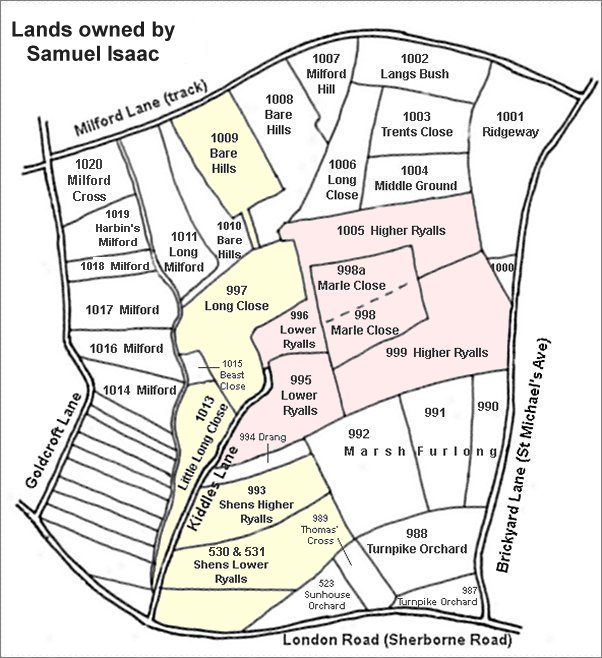
The area shaded pink are the former East Ryalls and West Ryalls leased in 1806, but later owned by, Samuel Isaac. The areas shaded yellow are other parcels owned by him although by 1842 he had sold off Parcels 996 and 1005 to Ann Collins and Parcels 998 and 998a to John Tanner Whiteley Pitcher. Samuel Isaac also owned several other parcels outside this map.
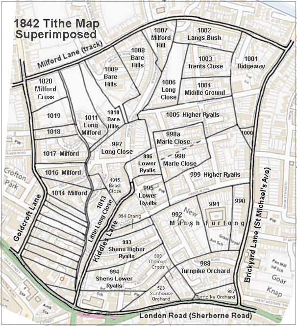
The 1842 Tithe Map superimposed (roughly) over a modern street map showing where several modern roads, for example Gordon Road, Grass Royal and Highfield Road, follow former field boundaries.
gallery
From my
collection
An indenture dated 8 April 1806 in which Samuel Isaac leases East and West Ryalls from John Newman Esq of Barwick. By the 1840s Samuel owned the land outright.
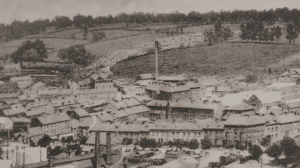
It wasn't all that long ago that there were more fields than houses in Yeovil. The western end of Higher Ryalls (999) is the field at top left immediately above the houses to the right of the top of the factory chimney and partially obscured by the first clump of trees.
This photograph dates to about 1900 and shows, at centre, the chimney of the Eastland Road brickworks with its associated buildings clustered around its base. To its left is the leather works built by William Bide (recogniseable by the double roof with a row of six black windows). Running along the bottom of the photograph is Station Road with the Alexandra Hotel at bottom right. In the top half of the photo, Eastland Road runs behind the chimney with fields either side!!!
From my
collection
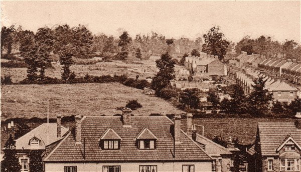
Enlarged from a postcard, this photograph was taken in 1913 from the top of Wyndham Hill. Across the bottom of the photograph are the backs of houses on the south side of Sherborne Road and at right are the houses of St Michael's Avenue opposite St Michael's church that were built on the eastern side of Marsh Furlong (Parcel 990). The remainder of Marsh Furlong (Parcels 991 and 992) are seen at centre to centre left, while beyond the hedgerow at left is Higher Ryalls (Parcel 999).
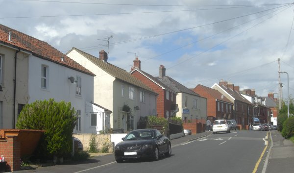
Grass Royal photographed in 2014. This photograph was taken from about the point where Lower Ryalls joined Higher Ryalls and looks east. The southern boundary of Higher Ryalls was roughly where the footpath is at right and went all the way to St Michael's Avenue, with the field itself running off to the left of this photograph.
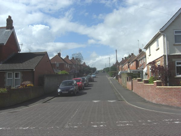
Hillcrest Road photographed in 2014. When I took this photograph I was standing on the southern footpath of Grass Royal, roughly where the southern boundary of Higher Ryalls ran (across the photo). Originally from here Higher Ryalls ran all the way up to Highfield Road.