milford
milford
A field originally called Milkeford
The 1589 Terrier, in referring to the boundaries of the great Middle Field of Kingston Manor, noted Milford several times as follows ".... From Gore Corner next the Highway to Goldcroft Lane end and up to Milkford Lane end.... In John Vicars close at Milkeford Lane end.... In Thos Phelps Close at Milkeford."
The
1633 Survey of
Kingston
recorded "John Bachiler
holds by
indenture dated
12 Oct 20 1622
granted by
Edward late lord
Stourton, Sir
William Stourton
now lord
Stourton and
dame Frances his
wife, and in
consideration of
a former lease
determinable on
the death of
John and a fine
of £10, 2½ acres
of pasture
sometime part of
the demesnes
lying in the
fields of
Kingston at a
place called
Milkeford
[Milford],
(except all
timber trees and
liberty to carry
them away), to
hold for 99
years and the
lives of his
sons and
daughter,
John Batchiler
mort,
Richard
Batchiler
34 and
Mary Batchiler
27. Rent 16d.
The surrender of a lease dated 30 March 1665 between Sir William Stourton and Thomas Marsh of Kingston, joiner, referred to ".... All those 2½ a pasture in the Lord’s domain of Kingston Fields called Mileford lately enclosed within the Manor of Kingston for 99 years on the lives of Thos Marsh the Elder, Thos Marsh the Younger, George Marsh and Marie Marsh."
In his will of 1715, Jeremiah Hayne left "... all that Close of Meadow and pasture ground lyeing at Milford containing by estimation five Acres ...". In his will of 1736, his son Jeremiah Hayne the younger left "... I order direct and appoint Give devise and dispose of all that Field called Milford or Quarry Close and all those three Closes lying at [Seclands ?] bounded on the Southside by Gorfield scituate lying and being within the parish of Yeovill aforesaid with their and every of their appurtenances unto my sister Hannah Danill for and during the Term of her natural Life ...".
In his will dated 15 March 1725, John Jeanes wrote "... I give devise and bequeath the same to my Nephews Thomas Burford of [word illegible] Clerke Office in the County of Middlesex Gentleman and John Burford one of the Fellows of Kings Colledge in Cambridge Gentleman and their heires dureing the naturall life of my daughter Mary together with one ground called Milford and two acres in Gold Croft One acre in Goare feild and Yeovill Bridge Mead together with all those foure peices of ground called Ryalls in the parish of Yeovill aforesaid In trust to apply and dispose of the rents issues and profitts thereof to the proper hands of my said daughter or as she shall appoint ... And as to for and concerning the said peice or parcell of ground called Milford from and after the decease of my said daughter Mary without any issue of her body my wife also being dead I give devise and bequeath the same unto my said Cousin Thomas Burford and to the heires male of his body And for want of such issue I give devise and bequeath the same unto my said Cousin John Burford and to the heires male of his body and for want of such issue I give devise and bequeath the said Ground called Milford unto my Cozen Richard Slade for and dureing the tearme of his naturall life and after his decease to his first second third and every other sonn and sonns of the said Richard Slade and for want of such issue to his first and every other daughter and daughters ...".
By the time of the 1842 Tithe Map the former field had been split into several parcels; the most northern was Harbin's Milford (1019) and identified separately in the 1846 Tithe Apportionment. Parcels 1018 to 1014 were all part of the former Milford - bounded on the west by Goldcroft Lane (today's Goldcroft) and in the east by Milford Brook. Parcel 1014 was recorded as pasture of 4a 0r 1p and Parcel 1017 was recorded as pasture with an area of 3a 0r 15p but the other two Parcels were not recorded.
As seen by the aerial photograph of 1946 below, those parts of Milford not built on with King Street and Crofton Avenue were used as allotments at this time.
Today the site
of the former
Milford field is
occupied along
its western
flank by the
houses and
gardens of
Goldcroft while
the eastern side
is occupied by
the northern end
of Portreeve
Drive and pretty
much the whole
of Valley Close,
King Street and
Crofton Avenue.
MAP

This map, based on the descriptions in the 1589 Terrier and the 1846 Tithe Map of Yeovil shows the approximate boundaries of the Manors of Kingston and Hendford as well as the manorial three-field system used in Kingston.
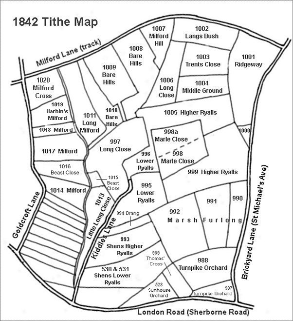
This map is based on the 1842 Tithe Map with field names added from the 1846 Tithe Award.
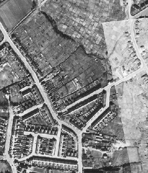
The 1946 aerial photograph with Goldcroft running from top left to bottom centre and Milford Lane at top right. Milford Brook is delineated by the wavy dark band of trees lining its banks and running from top left of centre towards centre right. King Street cuts across the centre right of the photograph from Goldcroft to Highfield Road at top right, with Crofton Avenue running off it.
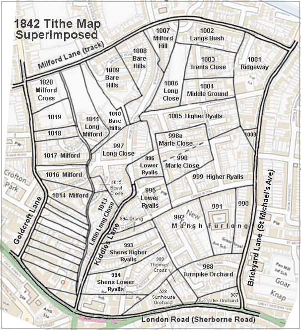
The 1842 Tithe Map superimposed (roughly) over a modern street map showing where several modern roads, for example Gordon Road, Grass Royal and Highfield Road, follow former field boundaries.