mount pleasant terrace
mount pleasant terrace
An early part of New Town
Mount Pleasant Terrace was built as speculative housing on a greenfield site in the 1880s. In fact it was built on a field known as Lower Ryalls.
When it was built the road we know today as Mount Pleasant was simply a track following a footpath across the fields from Kiddle's Lane to Brickyard Lane. Kiddle's Lane had earlier been known as Ryall's Lane and today is called Eastland Road while Brickyard Lane is today's St Michael's Avenue.
Initially just two houses, which still stand today, were built in what would become Mount Pleasant in 1884. Their datestone 'LP 1884' indicating they were built by local builder Lyndall Pomeroy. His parents and elder brother lived in the first of these when it was new. Mount Pleasant Terrace was built immediately afterwards and is shown on the 1886 Ordnance Survey map. These too survive today and line the northwestern side of Mount Pleasant.
By the time of the 1842 Tithe Map, a field known as Ryalls had been divided into Higher Ryalls and Lower Ryalls and Lower Ryalls had been further sub-divided into two fields (Parcels 995 and 996). The 1846 Tithe Award notes both parcels of Lower Ryalls as pasture (that is, grazing land for cattle, horses, etc.). At this time Parcel 995 was owned by Samuel Isaac and occupied by Charles Marsh. It was noted as pasture and measured 4a 3r 0p.
![]()
Many thanks to Sara and Michael Grint for giving me access to their original house deeds thereby allowing me to piece together the following somewhat complex history of the ownership of Lower Ryalls and the land that Mount Pleasant Terrace was ultimately built on -
By 1866 Lower Ryalls was owned by Joseph Dimmock and in this year he sold it to Charles Blake who, in turn, sold it to Henry Cole. Previously Stephen Harris had contracted with Blake for the purchase of a portion of the land including any buildings, etc. on it. However it appears that Harris couldn't raise all the necessary capital and in 1867 borrowed a sum of money from from coal and timber merchant (and later Mayor of Yeovil) Jabez Bradford on the security of the land in order to pay Cole.
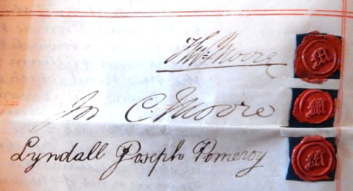
In 1868 a financial agreement (basically a mortgage) was made between Henry Cole, Stephen Harris and brothers and Yeovil solicitors Thomas Moore and Joseph Chaffey Moore at which time further monies were borrowed by Harris and (I think) Cole was finally paid off.
In order to pay of his debts owed on the land, in 1868 Harris sold part of the land to William Jackson and George Armstrong. By 1879 further portions of land had been sold to Samuel Trask, James Lucas and Aaron Partridge. By October 1879, still owing substantial sums of monies plus mounting interest, it appears that Harris finally sold the remaining land to the Moore brothers for the sum of £5.
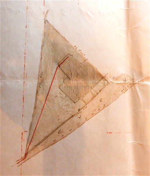
In 1884 the Moore brothers sold the corner plot of land (shaded pink in the map below) to Lyndall Pomeroy, who built the first two houses in Mount Pleasant. In 1886 Lyndall Pomeroy sold the portion of land and the two houses he had built thereon to his father Henry Pomeroy.
Lyndall's parents, Henry and Louisa, together with Lyndall's brother Frederick lived in No 1 while the other, No 3, was rented out. Lyndall's father, Henry, died in 1904 and his estate was valued at £2,031 (about £1,150,000 at today's value). On his death title of the properties reverted to Lyndall Pomeroy. By 1911 Lyndall had moved his family to Mudford where the census recorded him as a retired builder. In 1918 he was living in West Coker.
By 1918 the two houses were occupied by the Sutton and Rose families and at this time Lyndall sold the properties to his son Lyndall Henry James Pomeroy.
Maps
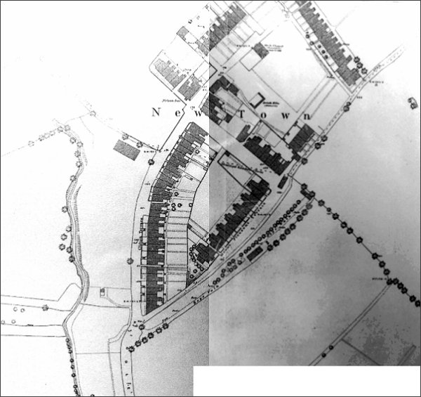
This map (stitched together from pretty poor copies - apologies) is the 1886 Ordnance Survey of New Town. At centre Mount Pleasant Terrace has been built even though the road itself is still only a track and on its southeastern side is the rope walk. Gordon Road runs between Kiddles Lane and Mount Pleasant, with the newly-built Nelson Inn on the corner. The three-sided structure above the 'To' in Town is a disused brick kiln, part of the once extensive brickworks in the vicinity. At top right is North Terrace, built in 1871 by Samuel Cridland. To its right, the track running off to the top right corner of the map would eventually become Grass Royal.
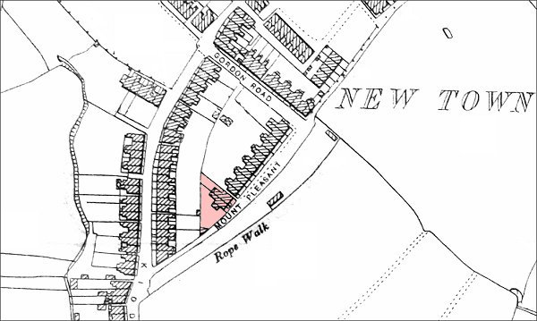
This map, based on the 1901 Ordnance Survey, shows the rope walk alongside Mount Pleasant. The area shaded pink is the area bought by Lyndall Pomeroy in 1884 - see also below.
Courtesy of Sara
and Michael
Grint
The area of land purchased in 1884 by Lyndall Pomeroy from the Moore brothers (this area is shaded pink on the previous map).
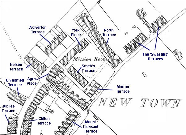
Map based on the 1901 Ordnance Survey showing the different speculative housing projects built in the early days of Newtown. Mount Pleasant Terrace is at centre bottom.
gallery
Courtesy of Sara
and Michael
Grint
The signatures of Thomas Moore, Joseph Chaffey Moore and Lyndall Joseph Pomeroy on the 1884 indenture transferring the land to Pomeroy on which he built Nos 1 and 2 Mount Pleasant.
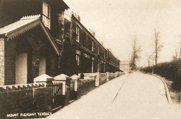
An early postcard of Mount Pleasant Terrace. The rope walk was the other side of the hedge at right. Nos 1 and 2 are seen at extreme left.
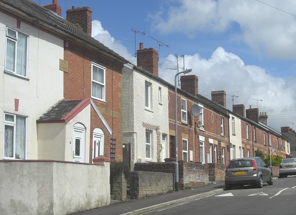
The two houses at left, with a datestone of 1884, were the first to be built in Mount Pleasant by Lyndall Pomeroy, followed within two years by the terrace of housing to the right called Mount Pleasant Terrace. All the houses faced the rope walk. The first house, at extreme left, was home to Lyndall's parents. Photographed in 2014.
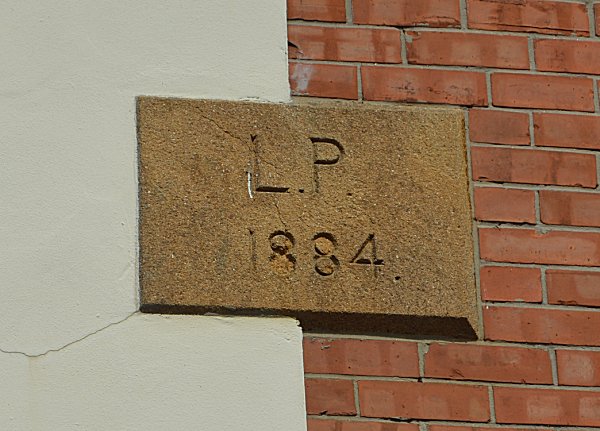
Lyndall Pomeroy's 1884 datestone referred to above. Photographed in 2014.
Courtesy of Sara
and Michael
Grint
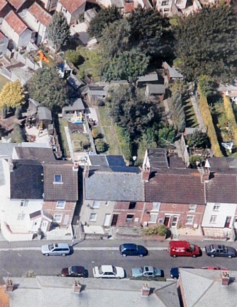
An aerial view of Mount Pleasant Terrace. No 1 and 2, built by Lyndall Pomeroy as described above, are seen at lower left with the rest of Mount Pleasant Terrace running off to the right.