roping path
roping path
The footpath that became Roping Road
At one time there was a continuous footpath from Yeovil to Yeovil Marsh and eventually to Ilchester by ancient footpaths and lanes. It started at Kingston at Red Lion Lane, continued along Roping Path to Mudford Road. It then crossed the road and entered a large field called Green Cross. As it continued across Green Cross, the footpath became known as Hillon Path and is referred to in the Terrier of 1589.
Roping Path, between Higher Kingston and Sparrow Lane (now Sparrow Road), had been the site of an 18th century rope and twine works mentioned in the Terrier of 1743 as 'Ropeing Field and Yard'. Roping Field was a large common field - a sub-field of the great medieval Middle Field of Kingston Manor. John Tatchell owned a rope factory in Higher Kingston in the early 19th century which may have been this factory. In 1848, after John Neal's rope factory in Reckleford was destroyed by fire, Tatchell took over Neal's company and moved his production from Higher Kingston to Wellington Villa.
Roping Path appears on Watt’s map of 1831, named as Roping Lane, as an extension of Red Lion Lane carrying to the north of Higher Kingston. It crossed Sparrow Lane, but even in 1901 noted as just a footpath, continuing northwards, running behind Green Quarry and finally joining Mudford Road.
In the early 19th century it was known as Fooks’ Lane because Mark Fooks of the wealthy gloving family owned property on its eastern side. It was named Roping Path from the 1841 census until it was laid out as a road in the 1920’s.
Even by the time of the 1901 Ordnance Survey the section between Higher Kingston and Sparrow Lane was still little more than a track and had no houses or other buildings whatsoever. This section became Roping Road, laid out in the 1920’s with a few houses. Most of the houses were built in the 1930’s.
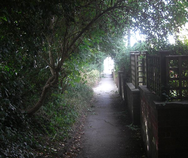
Today Roping Path survives as a footpath (see photograph below) extending from the end of that section of Roping Road lying north of Sparrow Road as far as Mudford Road, exiting almost opposite the entrance to Yeovil College.
MAPs

This map, based on the descriptions in the 1589 Terrier and the 1846 Tithe Map of Yeovil shows the approximate boundaries of the Manors of Kingston and Hendford as well as the manorial three-field system used in Kingston.
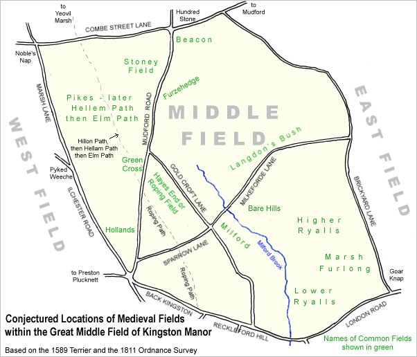
A conjectural
map of the great
Middle Field of
Kingston Manor
showing the
route of Roping
Path from
Back Kingston
(today's Higher
Kingston) as far
as Mudford Road.
The path then
continued as
Hillon Path, later Hellam Path,
later still Elm Path,
running from
Mudford Road,
across Green
Cross and then
across Pikes to
Combe Street
Lane - after
which it
continued on to
Yeovil Marsh and
then to
Ilchester.
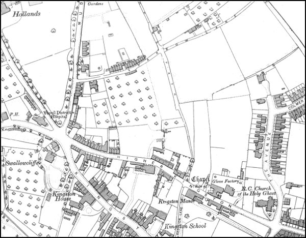
The 1901 Ordnance Survey showing Roping Path as a continuation of Red Lion Lane and running up the centre of the map From Higher Kingston to Sparrow Lane and then continuing on to Mudford Road north of Green Quarry.
gallery
This photograph
features in my
book 'Secret Yeovil'.
Roping Path between Sparrow Road and Mudford Road. Photographed in 2013.