stars lane
stars lane
A little lane apparently going nowhere
Stars Lane ran from South Street to Dodham, where it crossed the Dodham Brook and continued as a footpath across the lower slopes of Summerhouse Hill to Newton Surmaville.
The earliest references to members of the Starr family after whom Starrs Lane was named include Joseph Starr, who was a Portreeve of Yeovil in 1635, had previously been involved in litigation with the renowned adventurer, Tom Coryate of Odcombe. Starr sued Coryate for debt, with the latter calling Starr a "villipendious linnen-draper" who "conglomereth a mere farrago of lies". Joseph Starr gave two pounds towards the casting of bells for St John's church and his name appears on one of the bells.
The Churchwardens' accounts for 1693 show that Henry Starr paid his annual fee of 4d for a seat in St John's church "the Custome of a place on the forme that was his mothers".
In 1745 the Churchwardens' accounts lay out the expenditure incurred in repairs to Stars Lane and the bridge over Dodham Brook as follows -
|
In Stars Lane 137 Yards of Pitching @ 3d pr Yd is |
£1 14s 3d | |
|
For wheeling the Rubbish and making the Road good at ye foot of ye bridge |
6s 0d |
|
|
About the Guard Walls of ye Bridge Thos. Hulet & Man 1½ Day each |
4s 0d |
|
|
Robt. Hodges 1½ Day at 8d p. Day |
1s 0d |
|
|
To Lime about the same Work |
2s 0d |
|
|
To ye Carriage of Sand |
10s 0d |
|
|
In Stars Lane 49 Feet of Oak Posts and Rails at 4d p. Foot |
16s 4d |
|
|
Labour about putting in ye same |
2s 6d |
In the same year George Peckford was paid £1 8s 0d for "7 Load of Stones for repairing Stars Lane @ 4s per Load".
Stars Lane appears on Watt's map of 1806 but is undoubtedly centuries older. At the time of Watt's map Stars Lane reached all the way down to Dodham Brook and was flanked by orchards and fields. At this point a small footbridge, Dodham Bridge, crossed the brook allowing access to Summerhouse Hill. A couple of buildings were shown at the South Street end and Stars Lane House was shown as isolated amongst orchards about halfway between South Street and Dodham Brook.
In the middle of the eighteenth century Duke of Clarence Yard was built off Stars Lane to the west, with its entrance alongside the Duke of Clarence still there. Albion Terrace was built on the western side of Stars Lane between 1877 and 1886 as I have a lease for the land dated 1877 in my collection and the map on it shows the land was occupied by Stars Lane House and its gardens at that time, but by 1886 the terrace was shown on the Ordnance Survey. The same lease shows a 'proposed road' running off west from Stars Lane which became Summerhouse Terrace. During the latter half of the nineteenth and first half of the twentieth centuries much of the land to the east of Stars Lane was taken up by the town gas works.
Today Albion Terrace and the gas works have gone and consequently Stars Lane, once again, has few buildings.
MAPs
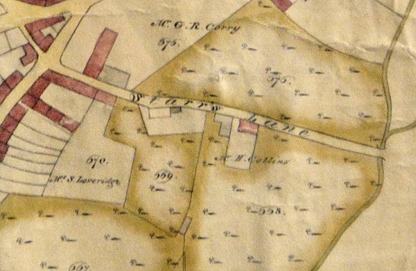
E Watt's map of 1806 showing Starrs Lane, flanked by orchards, running all the way to Dodham Bridge that crossed Dodham Brook.
gallery
From the Cave Collection (colourised), Courtesy of South Somerset Heritage Collection
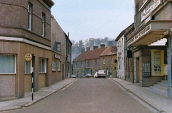
Photographed from South Street around 1960, this photograph shows the northern end of Stars Lane, with part of Albion Terrace at centre and the Gaumont Palace cinema at right.
Courtesy of
Chris Rendell
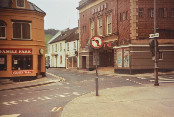
Stars Lane photographed from the Triangle in 1983. At this time the ground floor of the old Duke of Clarence was used by a Chinese takeaway and a taxi firm and I had just moved out of the flat above. See here.
From the Cave Collection (colourised), Courtesy of South Somerset Heritage Collection
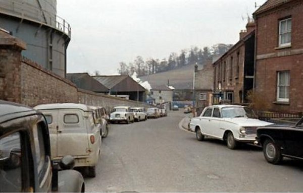
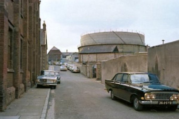
Photographed at the same time, this image further down Stars Lane shows Albion Terrace at right and the gas holder at left.
From the Cave
Collection
(colourised),
Courtesy of South Somerset Heritage Collection
Taken from the very bottom of Stars Lane, looking north, with Foundry House at left.

Photographed by
Doug Keyse,
courtesy of Andy
Keyse
A detachment of Boy's Brigade, Scouts and Cubs assembles at the bottom of Stars Lane for the St George's Day parade in 1968. At left many people will remember the scrapyard of Johnny Farr. In the background are the lower slopes of Summerhouse Hill with the footbridge over the railway at top right. At extreme right is the end of the first house in Summerhouse Terrace.
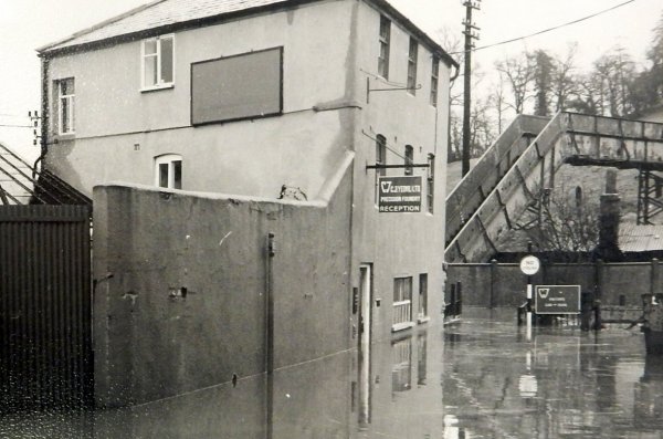
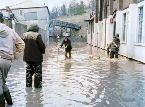
Dodham Brook at the bottom of Stars Lane would frequently flood before the flood alleviation scheme of the 1980s was built.
From the Cave
Collection
(colourised),
Courtesy of South Somerset Heritage Collection
Flooding was common in the 1960s when the River Yeo would swell and the extra volume of water would back-up Dodham Brook to cause flooding as seen in this photograph of 1972 taken at the bottom of Stars Lane. The second Dodham Bridge is seen in the background. The problem of flooding was overcome by a flood alleviation scheme of the 1980s.
From the Cave
Collection
(colourised),
Courtesy of South Somerset Heritage Collection
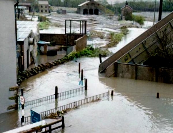
Taken at the same time as the previous photograph, this is at the foot of Dodham Bridge which crossed the railway tracks as well as Dodham Brook.