brunswick street
Brunswick street
Originally called New France, then France Street
Brunswick Street runs from Hendford as far as the junction of Penn Hill after which the road was named Belmont and then became Park Street, although today it is Park Street from Penn Hill as far as Central Acre. Brunswick Street was built by Peter Daniell in 1824-5.
An indenture dated 4 March 1825 in my collection notes "... a New Road of the said Peter Daniell ...", inferring its construction and completion in 1824-25. Also in 1825 "the new road belonging to Peter Daniell" was referred to in Thomas Binford's marriage settlement. This was a new road which, combined with Park Street running from the east, replaced the circuitous and somewhat steep route of Addlewell Lane and Chant's Path. Brunswick Street is shown, named, on Edward Bullock Watts' map of 1831 (below) and is also shown and named on Madeley's map of Yeovil of the same year.
Originally, however, the new road appears to have been known as New France and Pigot's Directory of 1830 listed Henry Hann as a painter, etc. of New France. It seems that after a few years the 'New' epithet had worn off and the road became known as France Street, but was Brunswick Street by the time of Watts' and Madeley's 1831 maps referred to above.
The Minutes of the Town Commissioners of 7 April 1835 state "Ordered that the new Street called Brunswick Street be forthwith completed and made good with hard materials by the Owners of the several Houses Buildings Grounds Lands and Hereditaments within and abutting upon such Street, by making a footpath on the north side of the said Street from one end thereof to the other of the average width of three feet six inches throughout, and by stoning the intermediate space of carriageway between such footpath and the opposite side of the said Street with good dew stone properly broken and laid on six inches in thickness at the least and by making and completing a good and sufficient drain throughout to the said Street communicating with the Common Sewer in the said Street for carrying off the water from the sides of the said Street and from the Houses Buildings and Yards situated in or abutting upon the same." The list of owners of properties in Bond Street listed in the minutes are tabulated below.
| Houses and other premises | Owners' Names |
| On the north side of the said Street | |
| House No 1 from Hendford | George Rendell |
| House No 2 | George Rawlins |
| House No 3 | George Rawlins |
| House No 4 | John Wilmott |
| House No 5 | John Wilmott |
| House No 6 | John Wilmott |
| House No 7 | John Pickford |
| House No 8 | John Pickford |
| House No 9 | Henry Whitmash |
| House No 10 | Henry Whitmash |
| House No 11 | John Bide |
| House No 12 | William Saint |
| On the south side of the said Street | |
| House No 1 from Hendford | Charles Nossiter |
| House No 2 | William Dix |
| House No 3 | George Harris |
| House No 4 | George Harris |
| House No 5 | George Harris |
| House No 6 | George Harris |
| House No 7 | George Harris |
| House No 8 | George Harris |
| House No 9 | George Harris |
| House No 10 | George Harris |
| House No 11 | George Harris |
| House No 12 | W L White |
| House No 13 | John Bide |
Robson's Directory of 1839 listed both beer retailer Robert Hickman and cooper Edward Lucas as 'of France Street'. Both men were listed as being in Brunswick Street by 1850. However in 1835 the Town Commissioners had ordered that "the new street called Brunswick Street be forthwith completed". It was named as Brunswick Street in the 1841 census.
The designation of this new stretch of road was made in honour of the Saxony Duchy linked to the Crown through the Hanoverian dynasty.
The road was later quite quickly populated with more buildings. It is believed that around 1870, residential Brunswick Place and Brunswick Terrace on the north side replaced the earlier cottages (probably) built and owned by George Harris and later, his brother Benjamin Harris.
There were light industrial properties such as glove factories and leather dressing yards with just one or two residences to the south. Most of these properties, residential and industrial alike, were demolished in the 1960s.
maps
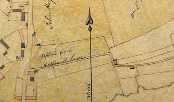
A section of Edward Bullock Watts' 1806 map - pre Brunswick Street - showing Addlewell Lane coming in from right centre with the section of Addlewell Lane, to the west of the zig-zag, that would later become Chant's Path joining Hendford at left.
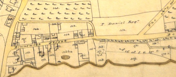
The section of Edward Bullock Watts' map of 1831, showing Peter Daniell's newly-built Brunswick Street. It was constructed around 1825 and, at the same time, Daniell built the road today called Penn Hill but on this map shown as the New Road.
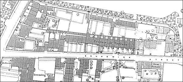
This map, based on the 1886 Ordnance Survey, shows Hendford running across the top left corner with Chant's Path running across the top half of the map and Brunswick Street running across the bottom of the map.
gallery
This
colourised photograph
features in my
book "Lost Yeovil"
A postcard dated 1906 looking along Brunswick Street with Brunswick Place and Brunswick Terrace at left.
Brunswick Place at right, seen from Brunswick Street in a colourised photograph of the 1960s. The road at the far end is Hendford.

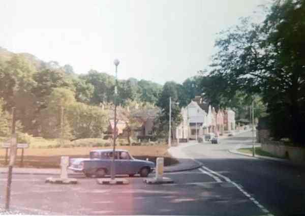
A colourised photograph of Brunswick Street seen from Hendford in the 1960s. Brunswick Place and Brunswick Terrace were down Brunswick Street, on the left roughly where the three cars are. At right is Nichols' Tannery, specialising in processing lambskins and suede.

... and turning round to look towards the junction with Hendford.
Courtesy of
Daniel Dicks
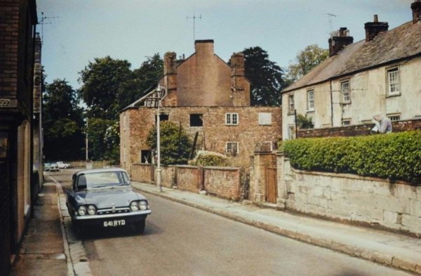
Brunswick Street (with the car) at the junction with Hendford, photographed in the 1970s.
Courtesy of
Colin Haine.
This photograph
features in my
book "Now
That's What I
Call Yeovil"
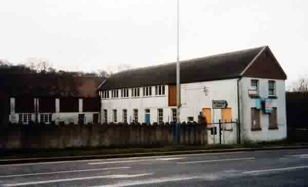
The Nichols' lambskin factory, closed and for sale in 1986. Photographed from Brunswick Street.

From the Cave
Collection
(colourised).
Courtesy of South Somerset Heritage Collection
Looking east along Brunswick Street during the late 1960s or early 1970s.
From the Cave
Collection
(colourised).
Courtesy of South Somerset Heritage Collection
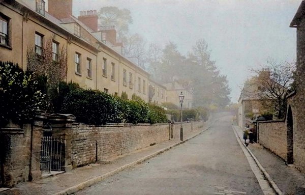
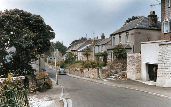
Photographed in the 1960s, this colourised photo looks along Brunswick Street towards Hendford with the steps to Chant's Path at right and the entrance to Aldondale Gardens at left. Brunswick Terrace is the tall block of houses just left of centre with the next block to the left at a slightly lower level. Brunswick Place was the next block of houses to the left ending by the building on the road whose flank wall has three black windows.
Courtesy of
Chris Rendell
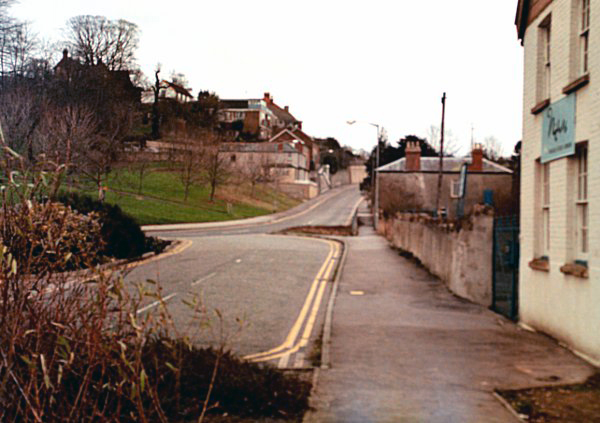
The Hendford end of Brunswick Street photographed in 1985.
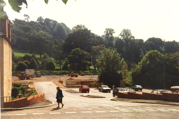
Preparing the new car park in Brunswick Street during 1988.
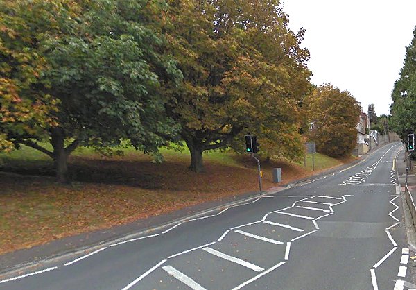
Brunswick Street today. The site of Brunswick Place and Brunswick Terrace is this grassy bank opposite the entrance to Goldenstones. Photographed in 2012.