Catshill Eight Acres
Catshill Eight Acres
A part of Preston Lower farm
Catshill has, through the ages, had various spellings including Kattshill, Cateshill, Cate's Lake and Catts Lake. In his will of 1696 John Knight, referring to a bequest to his son Simon Knight, wrote "Item I give unto him one leasehold estate containing fourteene acres of arable land be it more or less com[m]only called or knowne by the name of Kattshill lying in the Parish of Preston Balmonsey and now in the occupacon of Thomas Freke of the same parish... ".
An indenture of 1779 concerning Hayne properties refers to "Two acres arable.... lying in a common field called Westfield near Catts Lake next unto the way that leads unto Preston."
Catshill Eight Acres (Parcel 147), also known as Lower Catshill, was a field of Preston Lower Farm. The 1848 Preston Tithe Apportionment noted that Catshill Eight Acres was owned by Robert Tucker and occupied by Joseph Roberts. The Apportionment recorded that the field was arable and measured, unlike its name, just 6a 0r 32p.
John Brook the Younger became the tenant farmer, replacing Joseph Roberts, in 1857. He was the tenant farmer until his retirement around 1878.
All eight fields of Lower Farm whose names suggested an acreage such as Three Acre Mead, Four Acres, etc., were actually less than their names would suggest. However this is due to the use of 'Statute' measurements in the Apportionment which were actually smaller that 'Customary' measurements.
Catshill Eight Acres was bounded on the north by Catshill Ten Acres (Parcel 148), on the west by Pookhay Mill (Parcel 143) on the south by Little Bucks Mead (Parcel 146) and a Plantation (Parcel 146a) and on the east by the boundary brook separating the parish of Preston Plucknett from Yeovil.
By 1903 Grove Avenue had been constructed, passing through Catshill Eight Acres with West Park joining it from the east in the former field. At this time three houses had been constructed on the eastern side of Grove Avenue within the confines of the former Catshill Eight Acres while the western half of the field remained untouched. By 1927 four houses had been constructed on the western side of Grove Avenue and the final western portion of Catshill Eight Acres, about a third of the former field, was being used as allotments - as also shown in the 1946 aerial photograph below.
Today the former Catshill Eight Acres is completely filled with the houses and gardens of the central section of Grove Avenue and the whole of Linden Road.
For details on historic land measurement (ie acres, roods and perches) click here.
MAPS & Aerial Photograph
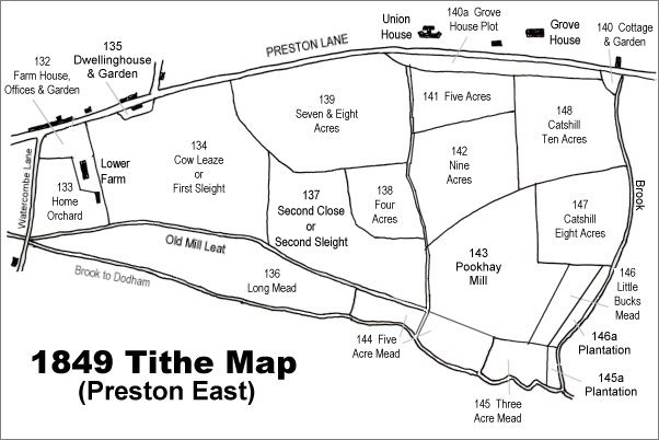
The 1849 Preston Tithe Map. Catshill Eight Acres is at centre right.
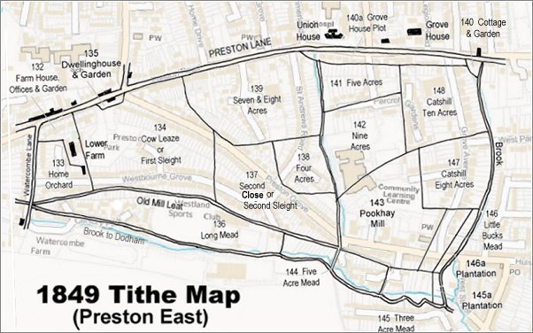
The 1849 Preston Tithe Map overlaid on a modern map (the 1849 map is slightly incorrect at bottom right).
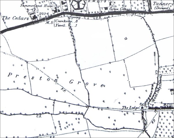
The 1889 Ordnance Survey shows the extensive fields of Lower Farm labelled 'Preston Grove' stretching eastwards. The dotted line across the fields, indicating a footpath, was the line of the later road, also called Preston Grove. Catshill Eight Acres is at centre right with the arrow indicating the flow of the boundary brook.
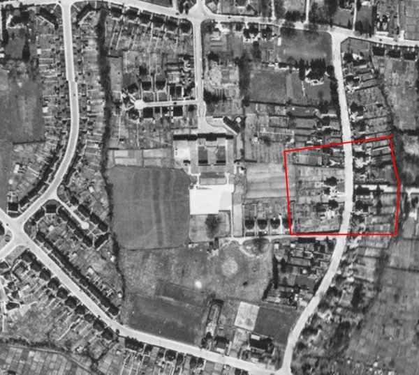
The 1946 aerial photograph showing the approximate boundaries of the former Catshill Eight Acres in red. Preston Road runs along the top, Preston Grove along the bottom left while St Andrews Road is at left and Grove Avenue at right.