Cow leaze
Cow Leaze
A part of Preston Lower farm
This field called Cow Leaze (Parcel 134) was a large field of Preston Lower Farm and was also known as First Sleight. The name 'cow leaze' simply means pasture land on which cows were grazed, while 'sleight' comes from the Old English sloeget, meaning a sheep pasture. Anciently the leghs (later corrupted to sleights) meant large, noble grounds or pastures.
The 1848 Preston Tithe Apportionment described Parcel 134 as 'Cowleaze & Barton'. In the context of the Tithe Apportionment entries, the term 'barton' is as given in FT Elworthy's 'West Somerset Word Book' of 1886; "That part of the farm premises which is specially enclosed for cattle, very frequently called the 'straw barton' because it is here that large quantities of straw are strewed about to be eaten and trodden into manure". The Preston Tithe Map shows that a small section of the field (0a 0r 20p) had been partitioned as Parcel 135, a dwellinghouse and garden, occupied in 1848 by French national Couly de Chavelle.
The Apportionment noted that Cow Leaze was owned by Robert Tucker and occupied by Joseph Roberts. It was described as pasture, with an area measured at 16a 2r 10p. It had a small lake towards its northwest corner.
John Brook the Younger became the tenant farmer, replacing Joseph Roberts, in 1857. He was the tenant farmer until his retirement around 1878.
Cow Leaze (Parcel 134) was bounded on the north by Preston Lane (today's Preston Road), on the west by Lower Farm farmhouse (Parcel 132) and Home Orchard (Parcel 133), to the south by the Old Mill Leat and Long Mead (Parcel 136) and to the east by Seven & Eight Acres (Parcel 139) and Second Close (Parcel 137).
As seen from the 1901 Ordnance Survey map below, Preston Grove was newly-constructed in the northeast corner of Cow Leaze and by 1927 the aerial photograph shows that the northeast corner of the field cut off by the new road had been filled with houses and gardens.
By 1946 the aerial photograph shows that the remainder of Cow Leaze, apart from the small area of allotments that would become Preston Park, had been filled with houses and gardens of Preston Road along the northern edge, Preston Grove in the northeast and Westbourne Grove to the south.
For details on historic land measurement (ie acres, roods and perches) click here.
MAPS & Aerial Photographs
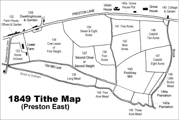
The 1849 Preston Tithe Map. Cow Leaze is at left.
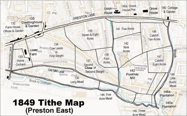
The 1849 Preston Tithe Map overlaid on a modern map.
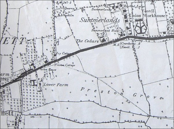
The 1889 Ordnance Survey shows Lower Farm at lower left with extensive fields labelled 'Preston Grove' stretching eastwards. The field in which the words 'Lower Farm' appear, and much of which later became Preston Park, was called Cow Leaze or First Sleight. The dotted line across the fields, indicating a footpath, was the line of the later road, also called Preston Grove.
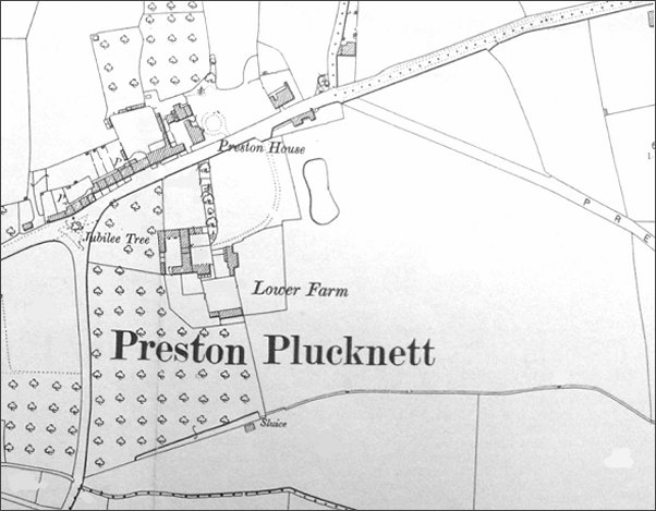
This map, based on the 1901 Ordnance Survey, shows Lower Farm and its outbuildings. Preston Grove has, by this time, been laid out but no houses have yet been built.
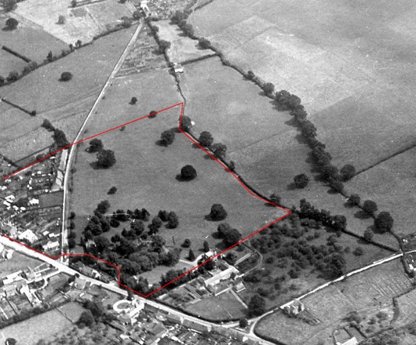
An aerial photograph of 1927, looking southeast. Preston Road runs across lower left and Watercombe Lane is at lower right while Westland's airfield is at top right and relatively newly-built Preston Grove runs up the left of the photograph. Preston Lower Farm is at centre bottom with the two streams running from lower right to top centre. The boundary of Cow Leaze is shown in red, but by this time combined with Second Sleight at top left.
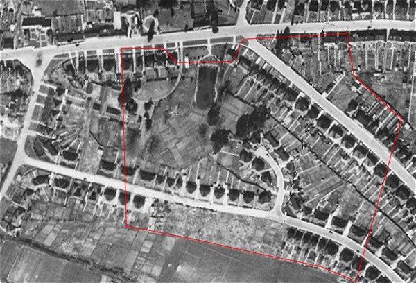
An aerial photograph of 1946 showing the approximate boundary of the former Cow Leaze shown in red and by this time all but completely filled with the houses and gardens of Preston Grove at top right and Westbourne Grove running from bottom right to centre left. What would become Preston Park was being used as allotments.
Gallery
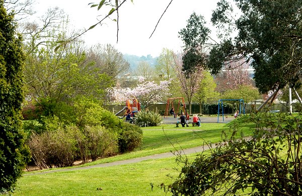
The last remaining part of the former Cow Leaze is Preston Park - here looking south. The sunken area at left is the filled-in pond. Photographed in 2015.
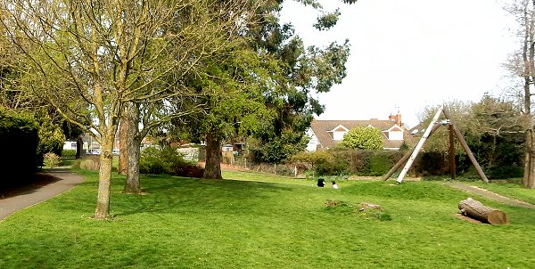
Preston Park looking north towards Preston Road. Photographed in 2015.