green cross
green cross
An ancient field once part of the great Middle Field of Kingston Manor
Green Cross was originally an ancient large sub-field of the great Middle Field of Kingston Manor laying roughly between the modern southern entrance to Yeovil College and Goldcroft and probably spanning both sides of Mudford Road, albeit chiefly to the west.
In earlier times, certainly by the sixteenth century, Green Cross was probably partitioned off into a number of smaller fields. In describing the boundaries of the great Middle Field of the Manor of Kingston, the 1589 Terrier recorded "From the Hayesend to Green Cross between the two Highways".
In his will of 1683, Henry Lavor wrote "First I give to Joane my wife ... All that close of pasture called Greencrosse containing by estimation six acres."
In his will dated 1763 William Daniell bequeathed "a Close of Land called Green Cross and also a Close of Land called Hollands containing about seven or eight acres more or less all which said Lands with all their Appurtenances I give my said Daughter Jane Daniell and her Heirs and Assigns forever".
A lease dated 25 March 1800 between glove manufacturer Henry Penny, his mother Margaret and sister Elizabeth on the one part and glove manufacturer John Ryall on the other part, refers to ".... All that Close of Arable Land containing by estimation Two Acres (more or less) sometime since inclosed and taken out of a Common Field called Ropeing Field and which the last mentioned Close was called by the name of Green Cross and heretofore in the possession of Elizabeth Noke Spinster and late of William Peddle deceased."
Certainly, by the time of the 1846 Tithe Apportionment, Green Cross (Parcel 1080), a small relic of the former large field of the same name, was part of Lower Stone Farm. The Apportionment noted that Green Cross was owned by Henry Goodford of Chilton Cantelo and the tenant was John Newman Berkley. The Apportionment also noted that it measured 5a 1r 38p and was used as pasture for grazing animals.
On 30 August 1849 Henry Goodford Esq. of Chilton Cantelo, leased to baker Nathaniel Bartlett of Yeovil, the following parcels of land, Land late in occupation of Mr John Newman-Birkley in Yeovil for £172 10s -
-
a cottage and garden Hundred Acres - 3a 2r 20p
-
Stoney Field and Green Cross - 8a 2r 10p
-
Higher Elm Path - 7a 2r 12p
-
Middle Elm Path - 8a 3r 35p
-
Lower Elm Path - 7a 1r 20p
-
Coombe Street - 5a 2r 10p
-
Beacon - 16a 2r 10p
-
Total - 58a 1r 26p
Green Cross was bounded by Mudford Road to the east, Stoney Field (Parcel 1088) to the northeast, Lower Stone Farm to the north and Middle Elm Path (Parcel 1086) and Lower Elm Path (Parcel 1081) to the west.
Today the northern part of Green Cross forms part of the Yeovil Recreation Centre south of the changing rooms while the southern part is occupied by houses and gardens of Mudford Road.
For details on historic land measurement (ie acres, roods and perches) click here.
maps

This map, based on the descriptions in the 1589 Terrier and the 1846 Tithe Map of Yeovil shows the approximate boundaries of the Manors of Kingston and Hendford as well as the manorial three-field system used in Kingston.
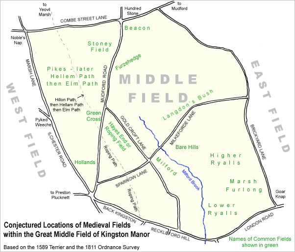
A conjectural map of the great Middle Field of Kingston Manor showing ancient sub-fields, most likely common fields, within the overall bounds of Middle Field.
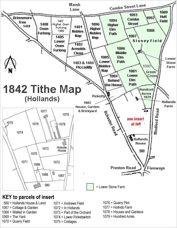 TheThe Hollands
area reproduced
from the 1842
Tithe Map.
Green Cross
is at centre right.
TheThe Hollands
area reproduced
from the 1842
Tithe Map.
Green Cross
is at centre right.
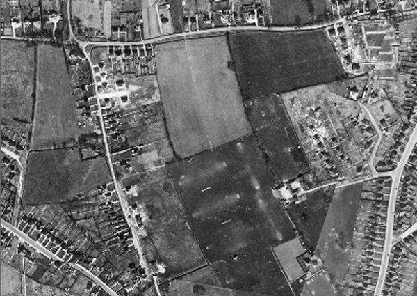
The 1946 aerial photograph showing Green Cross at lower right, with its southern half occupied by Mudford Road houses and gardens.
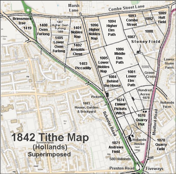
The 1842 Tithe Map superimposed over a modern map.
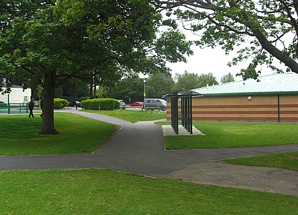
The changing room complex at right was built on what would have been the northern end of Green Cross. To the left, the car park and store at extreme left were built on the site of Lower Stone Farm.