stoney field
stoney field
An ancient field now part of the Pitch & Putt course
Stoney Field was originally part of the great Middle Field of Kingston Manor and was earlier called Beacon Ground. In earlier times, certainly by the sixteenth century, Lower Stone Farm was built in the eastern central part of the field and it was probably at this time that it was subdivided into Parcels 1087 and 1888. Green Cross (1080) to the immediate south was most likely part of the original field and was also partitioned off at the same time. It was bounded by Higher Elm Path (1094) and Middle Elm Path (1086) to the west, Combe Street (1093 and 1092) to the north, Hutt Field (1089) to the northeast and Mudford Road to the east. All of these fields became part of Lower Stone Farm.
In his will of 1736 (proved in 1741), Jeremiah Hayne wrote "... three acres of arable Land in Stoneyfeild [sic] with their and every of their appurtenances lying in Yeovill aforesaid unto my sister Elizabeth Goodford for and during the Term of her natural Life and from and immediately after her Decease Then I limitt appoint give and devise the same unto all and every the Child and Children of the Body of my said Sister Elizabeth Goodford his her and their Heirs and assigns for Ever ...".
The 1846 Tithe Apportionment recorded that Parcels 1087 and 1088 together amounted to 14a 0r 20p and were noted as arable for growing crops. The Apportionment noted that both parts of Stoney Field were owned by Henry Goodford of Chilton Cantelo and the tenant was John Newman Berkley. Parcel 1087 was recorded as measuring 3a 0r 30p and Parcel 1088 as 11a 0r 0p.
On 30 August 1849 Henry Goodford leased to baker Nathaniel Bartlett of Yeovil, the following parcels of land, "Land late in occupation of Mr John Newman-Birkley in Yeovil" for £172 10s 0d (around £200,000 at today's value) -
-
a cottage and garden Hundred Acres - 3a 2r 20p
-
Stoney Field and Green Close - 8a 2r 10p
-
Higher Elm Path - 7a 2r 12p
-
Middle Elm Path - 8a 3r 35p
-
Lower Elm Path - 7a 1r 20p
-
Coombe Street - 5a 2r 10p
-
Beacon - 16a 2r 10p
-
Total - 58a 1r 26p
Today Stoney Field (1088) is occupied by houses of Mudford Road along its eastern side with the remainder occupied by Chilton Grove. Stoney Field (1087) forms the southern half of the Pitch & Putt course of Yeovil Recreation Centre.
For details on historic land measurement (ie acres, roods and perches) click here.
map

This map, based on the descriptions in the 1589 Terrier and the 1846 Tithe Map of Yeovil shows the approximate boundaries of the Manors of Kingston and Hendford as well as the manorial three-field system used in Kingston.
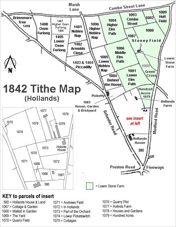
The Hollands area reproduced from the 1842 Tithe Map. Stoney Field is towards top right.
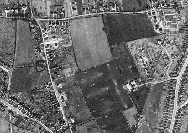
The 1946 aerial photograph showing Stoney Field (1088) at centre right with the two spurs of Combe Close under construction. To the east Stoney Field (1087) remains untouched and is to the immediate north of Lower Stone Farm.
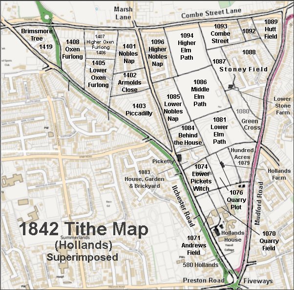
The 1842 Tithe Map superimposed over a modern map.