hardermeade
hardermeade
A 16th century field adjoining the East Field
Hardermeade, a 16th century field, went by many other names in early Terriers including Harde Mead, Hards Mead, Harder Mead Hill and Harder Mead - not to be confused with Hathermead.
A deed of 1589, referring to land sold by "Leonard and William Carent to Thomas Phellippes alias Phelpes of Yevell, mercer.... one close of land and pasture at Hardermeade containing 6 acres...."
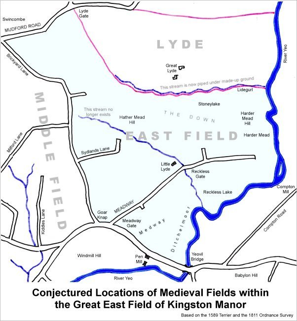
The 1589 Terrier indicates the three great medieval fields of Kingston Manor - west, middle and east - as shown on the map below. In describing the boundary of East Field it mentions Hardermeade as follows ".... from Reckless Lake in the outpart of the Meadway (the southern part of today's Lyde Road) unto the river before Compton Mill bounding upon the lands of the Lord Sturton in the north part right before the Meadway by the river towards Yeo. Bridge and upwards to the lower part of the Harde Mead...."
The 1633 Survey of Kingston noted ".... 5 acres of arable enclosed at a place called Hardermeade.... ".
The owner, in the mid fifteenth-century was Samuel Wills. In his will of 1667 his brother Mathew Wills wrote "All that my ground called Hardermead in the parish of Yeovell aforesaid which I purchased of my Brother Samuel Wills Item I give and bequeath unto my said wife".
The Hardermeade field (approximately) was therefore located next to the River Yeo, roughly where the word 'River' appears at the right edge of the map below. In terms of today's geography it was the area between Lyde Lane and the river.
map

This map, based on the descriptions in the 1589 Terrier and the 1846 Tithe Map of Yeovil shows the approximate boundaries of the Manors of Kingston and Hendford as well as the manorial three-field system used in Kingston.

A map of the great medieval East Field of Kingston Manor showing conjectured locations of several fields based on descriptions in the 1589 Terrier.