jacob's Medway
Jacob's Medway
Once part of the great medieval East Field of Kingston Manor
The southern part of today's Lyde Road was originally known as Meadway, Mead Way or Medway and is noted as such in the Terrier of 1589 ".... from Meadway Gate, the lower part of the way, unto Reckless Gate...." and ".... from Reckless Lake in the outpart of the Meadway unto the River before Compton Mill....". In 1754 it was referred to in a document as "Master George Prowse's Mead-Way" - George Prowse being the Lord of Kingston Manor at that time.
On the corner of Meadway (today's Lyde Road) and London Road (today's Sherborne Road) was a large field that had once been part of the great medieval East Field of Kingston Manor. This field was called Meadway, or Medway and in today's terms stretched along Lyde Road from the junction with Sherborne Road as far as the Lidl store and stretched along Sherborne Road from the junction with Lyde Road to beyond the railway line.
The large medieval field called Meadway was broken up into several smaller fields, or parcels. One of these, known as Jacob's Medway (Parcel 867) ran along Lyde Road from around the site of today's Camborne Grove as far as, and including, the land where the Lidl store now stands. Presumably referring to what would become known as Jacob's Medway, a lease dated 4 April 1673 between Sir William Stourton and Edward Jacob the Elder of Kingston, Gent, refers to ".... in the Manor of Kingston, also 1 close meadow or pasture Meadway 7a." Jacob's Medway became part of Pen Mill Farm.
A lease for seven years dated 17 February 1800 between George Bragg Prowse of Yeovil, Esq., and Robert Tytherleigh of Penn Mill, Yeovil, Miller, refers to ".... meadow or pasture called Great Meadway 15a, meadow or pasture Jacobs Meadway 8a in Kingston juxta Yeovil."
The 1846 Tithe Apportionment noted that Jacob's Medway was owned by William Jones Prowse (Lord of Kingston Manor at that time) and the tenant was Thomas Frost. The Apportionment noted that it was used as meadow and measured 6a 0r 0p.
Jacob's Medway was bounded on the northwest by Meadway (today's Lyde Road), on the southwest by Drang (Parcel 866), on the southeast by Medway (Parcel 868) and Thompson's Close (Parcel 869) and on the northeast by East Beachams Close (Parcel 872).
A Counterpart of Lease for seven years dated 25 March 1859 between Captain William Prowse of Enham House, Southampton, Retired Captain RN, and John Stone of Pen Mill Inn for both the inn and the adjoining farm, included Jacob's Medway. The acreage of the field, however, was noted as 8a 0r 0p but this discrepancy may be due to the use of 'Statute' measurements in the Apportionment which were different to local 'Customary' measurements even though they used the same units.
By the 1880s Jacob's Medway had been sold and Camborne Grove, Camborne Place and Camborne Street had been laid out, although the majority of the houses were built slightly later. The rest of the field remained unused until the Lidl store was built in relatively recent times.
For details on historic land measurement (ie acres, roods and perches) click here.
maps & Aerial photographs

This map, based on the descriptions in the 1589 Terrier and the 1846 Tithe Map of Yeovil shows the approximate boundaries of the Manors of Kingston and Hendford as well as the manorial three-field system used in Kingston.

A map of the great medieval East Field of Kingston Manor showing conjectured locations of several fields based on descriptions in the 1589 Terrier.
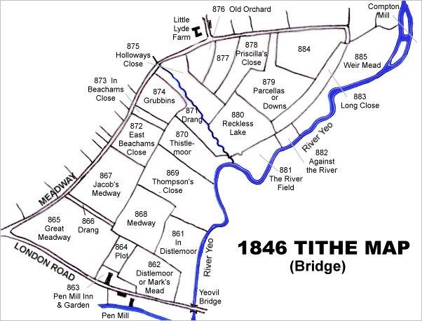
This map is based on the 1842 Tithe Map with field names chiefly added from the 1846 Tithe Apportionment.

The 1842 Tithe Map superimposed (roughly) over a modern street map. Bearing in mind the relatively primitive surveying equipment of the 1840s they weren't all that far out.
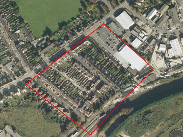
A modern aerial photograph 'borrowed' from Google Maps with the approximate boundaries of Jacob's Medway (Parcel 865) outlined in red.