Mudford Road turnpike house
Mudford road turnpike house
Not in its original location
In 1753, Turnpike Commissioners were appointed for "repairing and widening the roads" of Yeovil. At the first meeting of the Yeovil Turnpike Trust on 12 June 1753, they ordered that "three capital gates be erected" at Hendford Bridge (by today's Railway Tavern) and also known as Hendford Gate, Goar Knap (spanning Sherborne Road on the town side of the junction of St Michael's Avenue - later replaced by Yeovil Bridge Turnpike House) and the "Head of Kingston". There was also the Pen Style Stop Gate near the entrance leading from Pen Style to Newton, later replaced by Pen Style Turnpike House. Other gates at various times being Watercombe Side Gate, Combe Street Lane "Hutt Gate" - later replaced by Mudford Road Turnpike House, Milford Lane Side Gate (today's Goldcroft) and Jernegan's Hut Side Gate at Vagg.
Collectors at each of these gates received a salary of six shillings per week or "eight shillings until the toll houses are completed".
The Combe Street Lane gate, literally a gate across the road, was sited at the junction of Combe Street Lane and Mudford Road. A toll keeper's hut was built around 1840 in a field called Hutt Field on the 1842 Tithe Map. Hutt Field was a roughly triangular field on the corner of Combe Street Lane and Mudford Road which bounded the field on its northern and eastern sides. On the 1842 Tithe Map the words 'HUTT GATE' are written across the Mudford Road - Combe Street Lane / Stone Lane crossroads, being one of the town's early toll gates. The hut was shown in the field called Hutt Field (Parcel 1089) and was clearly the toll keeper's 'hut' or house.
It was referred to as Combe Street Lane Side Gate in the notices of toll tenders from 1825 until 1859 when the toll gate was moved to the junction of Mudford Road and St Michael's Avenue and the toll house, seen below, was built there.
A conveyance of 1867 between the Yeovil Turnpike and George James William Prowse was signed for the site of the Tollhouse at Coombe Street Lane, Yeovil for £30 situated at the entrance to Coombe Street Lane out of the Turnpike Road leading from Yeovil to Mudford and abuts on land belonging to GJW Prowse of Frampton Cotterell, Gloucs. Signed by the Trustees – George Harbin, George Bullock, Robert Chaffey, WH Helyar and William Neal.
The former toll house is now called Turnpike Cottage.
It is Grade II Listed.
Turnpike Lodge, circa 1850 (sic). Local stone cut, squared and coursed, Ham stone dressings; plain clay tiled roof with fish-scale bands, between coped gables. Asymmetric plan, Tudor-Gothic style. One storey with attic and two storeys, mullioned windows with labels and cast iron lattice casements, Two bays treated separately left-hand lower; C20 bay window to ground floor replacing former entrance and bay window. Entrance now to northeast. To Mudford Road a 2-storey return wing and a stepped chimney.
MAP

An extract from the 1842 Tithe Map showing Hutt Gate at the centre. Mudford Road comes up from the bottom left, turns through ninety degrees and continues towards the bottom right. Combe Street Lane comes in from centre/top left and Stone Lane runs to top centre. The blue-bounded area is the detached part of Preston Plucknett parish housing Stone Farm.
gallery
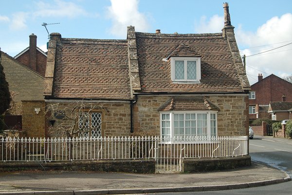
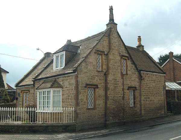
Combe Street Lane Turnpike House, now called Turnpike Cottage. The elevation to St Michael's Avenue. Photographed in 2013.
Combe Street Lane Turnpike House, the corner elevation to St Michael's Avenue at left and Mudford Road at right. Photographed in 2013.
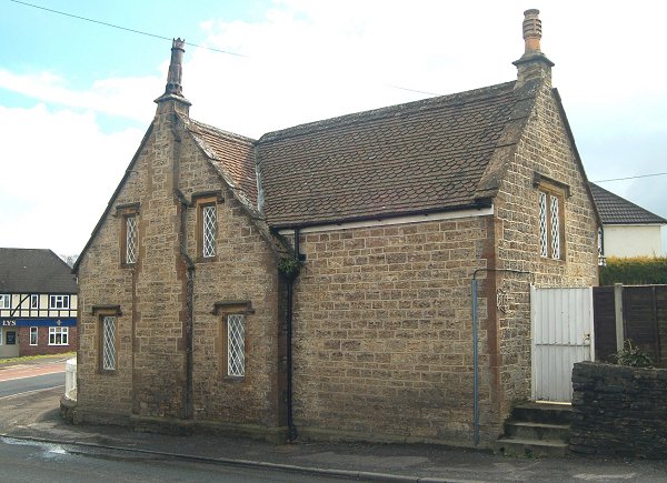
...and seen from Mudford Road in 2013.