Pookhay Mill
Pookhay Mill
A part of Preston Lower farm
Pookhay Mill (Parcel 143) was a large field of Preston Lower Farm. Pookhay, also known as Peckhay, comes from 'Pook' - a dialect word meaning to roughly throw up a cut crop of hay into heaps or small stacks. At the southwest corner of this field the Old Mill Leat that has flown from Watercombe in the west, turns south to join the brook to Dodham. It is therefore most likely that the former mill once stood in the southwest corner of this field.
The 1848 Preston Tithe Apportionment noted that Pookhay Mill was owned by Robert Tucker and occupied by Joseph Roberts. The apportionment noted that the field was used as pasture for grazing livestock and measured 11a 0r 5p.
John Brook the Younger became the tenant farmer, replacing Joseph Roberts, in 1857. He was the tenant farmer until his retirement around 1878.
Pookhay Mill was bounded on the west by the brook that flowed south from Preston Road by the Union Workhouse and joined the Old Mill Leat in the corner of Pookhay Mill. On the south it was bounded by Five Acre Mead (Parcel 144) and Three Acre Mead (Parcel 145), to the east by Little Bucks Mead (Parcel 146) and Catshill Eight Acres (Parcel 147) and to the north by Nine Acres (Parcel 142).
Today the southern portion of former Pookhay Mill is occupied by houses and gardens of the north side of Preston Grove while most of the rest is occupied by Summerleaze Park School (now Oaklands Primary School).
For details on historic land measurement (ie acres, roods and perches) click here.
MAPS
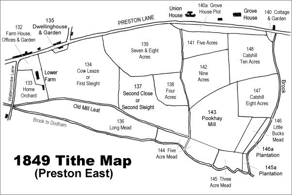
The 1849 Preston Tithe Map. Pookhay Mill is in the bottom right quadrant.
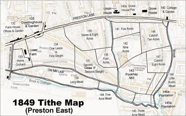
The 1849 Preston Tithe Map overlaid on a modern map (the 1849 map is slightly incorrect at bottom right).
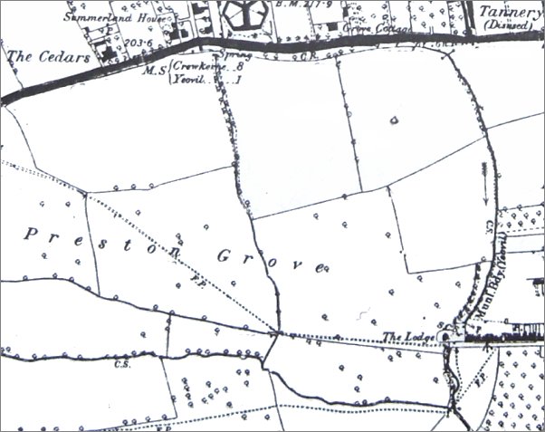
The 1889 Ordnance Survey shows the extensive fields of Lower Farm labelled 'Preston Grove' stretching eastwards. The dotted line across the fields, indicating a footpath, was the line of the later road, also called Preston Grove. Pookhay Mill, by this time combined with Little Bucks Mead, is the L-shaped field with the letters 'OVE' of Preston Grove.