drang
drang
A lane-width field
There are several fields in Yeovil called Drang - this one in New Town, two close to Little Lyde Farm and a further example off Lower Larkhill Lane. FT Elworthy in his "West Somerset Word Book" records that 'Drang-Way' was a passage or narrow alley, invariably between two walls, while FW Matthews in his "Glossary of the West Somerset Dialect" recorded that Drang, or Drong, was a narrow way between high hedges or walls or earth banks. The word is probably a British survival of the Welsh dre meaning a street or road.
The Drang in New Town (Parcel 994) was shown on the 1842 Tithe Map and the 1846 Tithe Apportionment noted that it was just 1r 20p in area and used as arable for growing crops. It was a long, thin field running east from Kiddle's Lane (today's Eastland Road) and gave access to Marsh Furlong (992) at its eastern end. To the north it was bounded by Lower Ryalls (995) and to the south by Shen's Higher Ryalls (993).
In the late nineteenth century (certainly by 1886) Drang became the site of one of Yeovil's rope walks and today is covered by the housing on the southern side of Mount Pleasant.
For details on historic land measurement (ie acres, roods and perches) click here.
maps

This map, based on the descriptions in the 1589 Terrier and the 1846 Tithe Map of Yeovil shows the approximate boundaries of the Manors of Kingston and Hendford as well as the manorial three-field system used in Kingston.
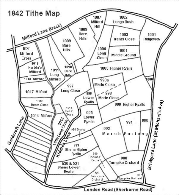
This map is based on the 1842 Tithe Map with field names added from the 1846 Tithe Award.
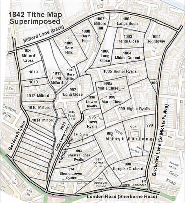
The 1842 Tithe Map superimposed (roughly) over a modern street map showing where several modern roads, for example Gordon Road, Grass Royal and Highfield Road, follow former field boundaries.
gallery
From my
collection
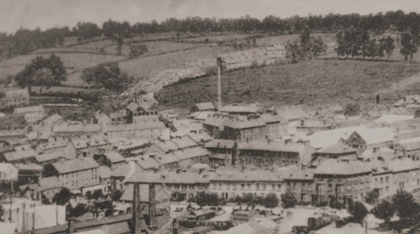
It wasn't all that long ago that there were more fields than houses in Yeovil. Drang ran along the hedgerow seen behind the chimney at centre, from the houses in Eastland Road at left as far as the first clump of trees at centre top right.
This photograph dates to about 1900 and shows, at centre, the chimney of the Eastland Road brickworks with its associated buildings clustered around its base. To its left is the leather works built by William Bide (recogniseable by the double roof with a row of six black windows). Running along the bottom of the photograph is Station Road with the Alexandra Hotel at bottom right. In the top half of the photo, Eastland Road runs behind the chimney with fields either side!!!