yeovil people
Joel Hardy
Brickmaker and Brewer
Joel Hardy was born in Uplyme, Devon, on 21 July 1782, the fourth of the eight children of Thomas Hardy (1748-1804) and Mary née Lane (b1750). Thomas and Mary's children were; Thomas (1773-1774), Martha (b1775), Mary (1779-1850), Joel, Frances (1785-1854), Charlotte (b1787), Edith (b1789) and James (1796-1856)..
On 28 July 1811, Joel married Melina (or Mellena) Seward (1787-1860) at St Johns church, Yeovil. They lived at Penn-Field, London Road. Joel and Melina were to have five children, all born in Yeovil; Henry (b1812), Edwin (1816-1837), George Thomas (b1819), Robert (1821-1860) and Elizabeth (1826-1864).
Joel was listed in the Poll Books of 1832 to 1846 by virtue of owning a freehold house at Pen Field. Robson's Directory of 1839 listed him as a Brick Maker and also as a Brewer of London Road - the later Royal Osborne Brewery next door to Pen Field (not Parcel 521 on the map below, which was a different brewery).
The 1841 census listed him as a 55-year old Common Brewer with Melina and three of their children. Pigot's Directory of 1842 also listed him as a Brewer & Maltster.
In 1851, Joel was noted as an investor in the South Western Railway Company, but his occupation was given as a land steward..
In the 1851 census he was listed as a Retired Brewer living at 28 London Road with Melina, their daughter Elizabeth and a domestic servant. Melina died in 1860 and in the 1861 census Joel was living on Sherborne Road with his daughter Elizabeth, giving his occupation as House & Land Proprietor.
Joel Hardy died in Yeovil on 18 September 1861.
MAP
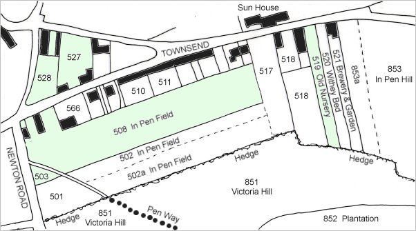
This map is based on the 1842 Tithe Map, with the lands owned and/or occupied by Joel Hardy coloured green. The various parcels were as follows -
| Parcel | Description | Owner | Occupier |
| 503 | Garden | Mary Marshall | Joel Hardy |
| 508 | In Pen Field | Mary Marshall | Joel Hardy |
| 519 | Old Nursery | Rebecca Eason | Joel Hardy |
| 527 | Cellar, Yard & Garden | Joel Hardy | Joel Hardy |
| 528 | Cellar, Yard & Garden | Joel Hardy | Joel Hardy |
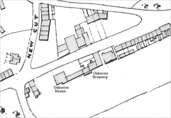
A portion of Hickes & Isaacs' map of 1858. Osborne House had been built around 1830 (it is shown on Watts' map of 1831) but this is the first map on which the Osborne Brewery buildings are shown, albeit un-named on the original map.
Gallery
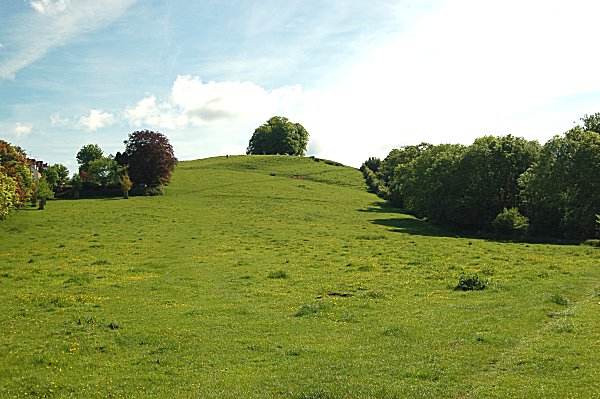
The western flank of Wyndham Hill seen from Newton Road. This was mostly owned by Joel during the 1840s and 1850s. At the very bottom of the right corner is a trace of the former Penn Way that divided Parcel 503 from Parcel 508. Photographed in 2013.
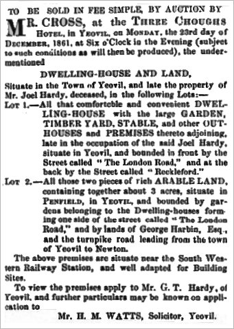
The notice of sale, in the 17 December 1861 edition of the Western Flying Post, of the land holdings of Joel Hardy following his death.
Lot 1 was clearly Joel's home, and was Parcel 527 on the first map above, since the cottages in 'New Cut' (today's Wyndham Street) were already built. It is interesting to note that the premises included a timber yard.
Lot 2 was the large three-acre field, shown as Parcels 503 and 508 on the first map above. Parcel 503 had become detached from Parcel 508 by the insertion of the lane called Penn Way. This now forms the lower slopes of Wyndham Hill adjoining Newton Road.