Hendford hill
Hendford Hill
A steep descent to the town
Taking its name from the Manor of Hendford through which it passes, Hendford Hill drops steeply from its southwestern end by the Quicksilver Mail and the Dorchester Road as it descends to the Railway Hotel, by today's Horsey Roundabout.
Although it was the main route from Yeovil to the west, for much of its existence the road up the hill was little more than a country lane, as seen in the 1843 sketch below. Running alongside for the upper part of the hill is Lovers' Lane which originally represented a key transport route from Dorchester to Yeovil. Lovers' Lane is, today, an undeveloped wooded lane set in a cutting that now serves as a footpath.
Lovers' Lane pre-dates Hendford Hill (the road) since it was originally part of the old Roman road between Dorchester and Ilchester. Historically the route continued north down the hill by Rustywell towards a Roman farmstead at the bottom, which was excavated in the 1920’s. Lovers' Lane at one time followed two routes and the more easterly route, now truncated by housing at the southern end, is considered to be the original line of the road but was stopped up by the Corporation in 1835.
In 1853 the first railway line to reach Yeovil was the Bristol and Exeter Railway, as a branch line from Taunton via Langport and Martock. It had a terminus at Hendford and Hendford Station, Yeovil’s first railway station, opened in 1853. Towards the lower (northern) end of the hill the railway bridge was built to carry the road over the railway line, which sits in a brick lined cutting.
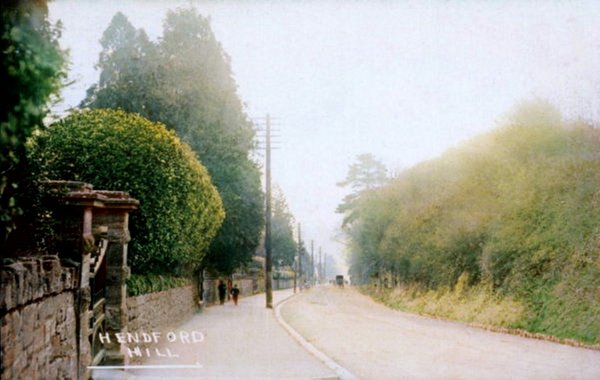
However the road we see today has actually changed dramatically. During the mid-nineteenth century the gradients of the hill were altered by the cutting towards the top of the hill in order to make ascending the hill easier. I couldn't find any record of when the levelling took place but a riot that took place between navvies, presumably working on the project, took place in 1862 and resulted in the death of a policemen (see below). The levelling created the cutting bank along the southeastern run of the road we see today and also affected the Quicksilver Mail by turning it from a three-storey building into a two-storey building.
As seen from the 1842 Tithe Map below, Hendford Hill had very few houses at this time. However during the next two decades more and more grand houses and villas were built along the western side of the road, opposite the cutting bank. These tended to be occupied by wealthier middle classes.
MAPS
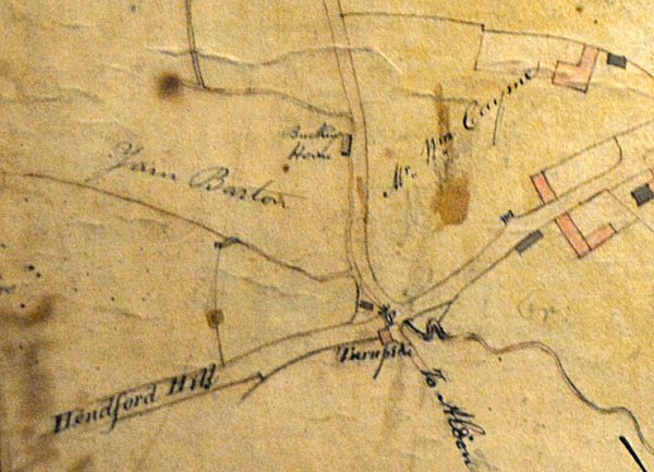
E Watts' map of 1806 on showed the bottom (northern end) of Hendford Hill. The only house is that of the Turnpike Gate Keeper - shown as a pink rectangle above the word 'Turnpike' (in the location of today's Railway Hotel) with the actual gates drawn across the road. Running to the north is Horsey Lane with its sole building, the Bucking House, lying in the field Yarn Barton.
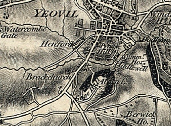
Probably the earliest map showing the whole of Hendford Hill - the 1811 Ordnance Survey map. The only building shown is the Quicksilver Mail, at the top of the hill.
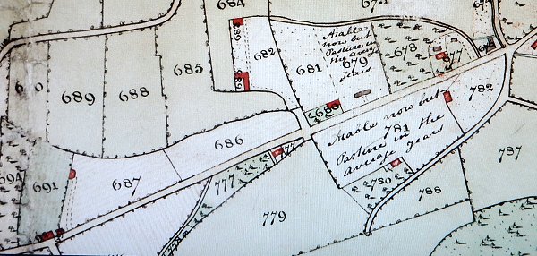
This is part of the 1842 Tithe Map. At bottom left is the Quicksilver Mail opposite Dorchester Road and at top right is the junction with Hendford and Horsey Lane.
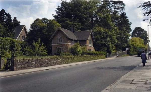
Parcels 686 (listed as 'Gardens') and 687 (listed as 'Cottages and Gardens') were both owned by fancy goods dealer Ince Gamis. Parcel 682 was Rustywell Field, owned by glove manufacturer and later Mayor of Yeovil Robert Tucker, and the houses therein belonging to Thomas Sydenham. Tucker also owned Parcel 677, today known as The White House, and Parcel 678 known as Rustywell Orchard. Parcel 777 - is the field and cottage, known as the Swiss Cottage, owned by glove manufacturer and later Mayor of Yeovil Frederick Greenham.
However, both sides of Hendford Hill for its lower (northern) half were occupied by the garden nursery of Edward Pierce - Parcels 679, 678, 781 and 782. The cottage in Parcel 782 was owned and occupied by Thomas Hartnell.
gallery
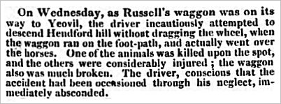
This report, from the 9 May 1835 edition of the Gloucestershire Chronicle, highlights the perils of Hendford Hill's steep gradients before the alterations just a few years later.

This report from the 25 January 1862 edition of the Leeds Times indicates that navvies were working on the realignment of the hill's gradients at the time of this riot that ended with the death of a police constable.
![]()
The following
images of
Hendford Hill
are not in
chronological
order but
commence at the
bottom of the
hill (the
northern end)
and finish at
the top (the
southern end).
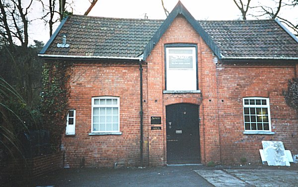
This photograph
features in my
book 'Yeovil From Old Photographs'.
The stable block at the bottom of Hendford Hill, behind the Railway Inn, at one time owned by the Quicksilver Mail and a trace of horses were stabled there. In order to assist with the long, hard pull of horse-drawn mail coaches to the top of the hill by adding this fresh trace of horses to pull the coaches. When the coach reached the Quicksilver the travellers would alight for refreshment in the inn; the tired horses would be led back down the hill to rest in these stables, while the fresh trace of horses would continue the journey west. Photographed in the 1990s.
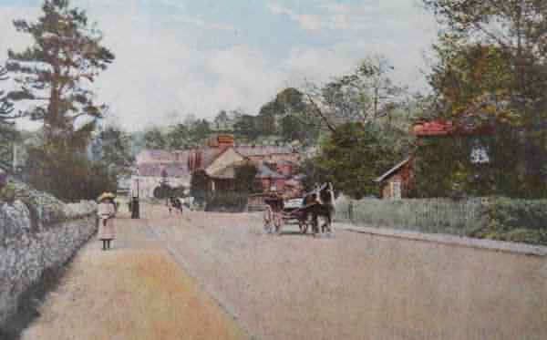
A postcard of around 1905, looking down the lower slopes of the hill.
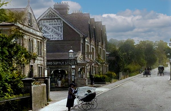
This
colourised photograph
features in my
book 'Yeovil From Old Photographs'.
This postcard of 1912 looks up Hendford Hill from the junction with Horsey Lane, glimpsed at right. At left is the Railway Hotel, beyond which is Aldon Terrace. The Hendford Supply Stores was run by George Maidment from the late 1870s until his death in 1909.
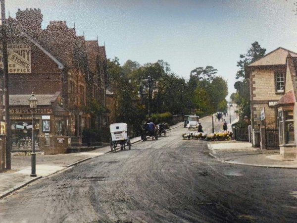
The same view seen in a colourised photograph of around 1920 with a horse-drawn baker's delivery van outside the Hendford Supply Stores. The photograph was clearly taken on a market day since, at right, a small flock of sheep is being taken to market.
This
image
features in my
book 'Yeovil
- The Postcard
Collection'.
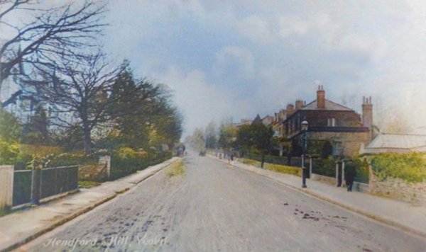
A colourised postcard of Hendford Hill dating to around 1905.
From the Cave
Collection
(colourised),
Courtesy of South Somerset Heritage Collection
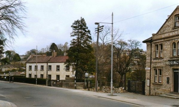
Looking across from the bottom of Hendford Hill, from outside the Railway Hotel, towards the cottages that were demolished in the 1960s.
From the Cave
Collection
(colourised),
Courtesy of South Somerset Heritage Collection
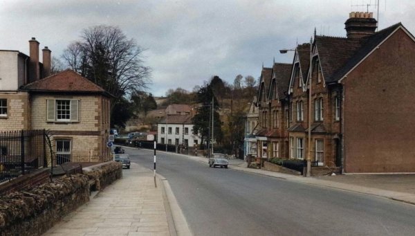
Looking back down the hill from just past Aldon Terrace (at right). Photographed in the 1960s.
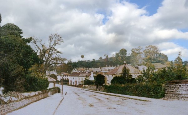
A colourised photograph of around 1880 (note the lack of Aldon Terrace) from the railway bridge and looking back to the foot of Hendford Hill.

This colourised photograph, with Aldon Terrace at centre, was taken around 1905. Note the large, square house to the immediate right of the terrace which is absent in all later photographs. Note also Penn Hill in the background, with barely a building upon it. At extreme right is the railway bridge.
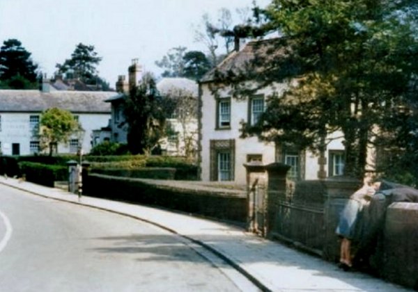
Largely the same scene, in a colourised photograph of the 1970s.
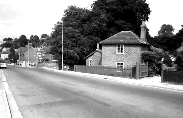
Looking back to the railway bridge around 1965.
Courtesy of John
Cornelius
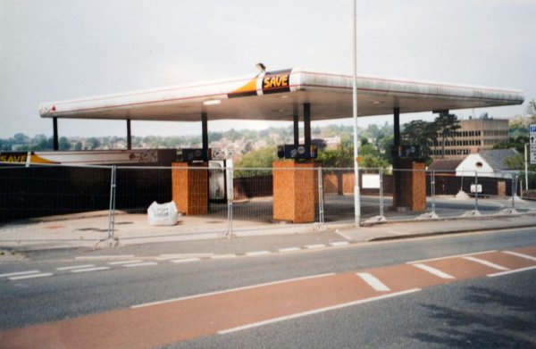
Photographed in 2003, just after it closed and shortly before it was demolished, this petrol filling station was almost opposite Southwoods.
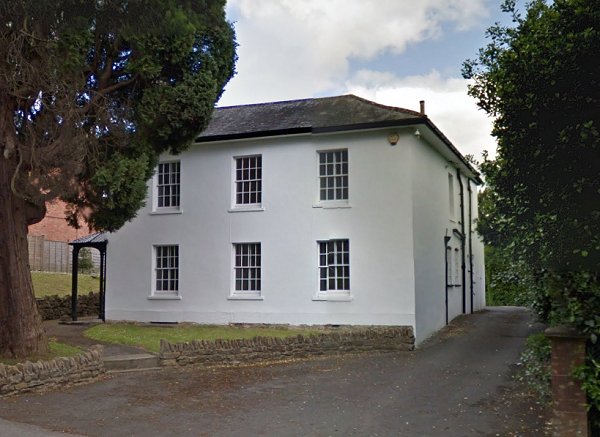
Towards the bottom (northern) end of Hendford Hill and on the western side, the White House, 114 Hendford, is a listed building in the Hendford Hill conservation area. One of the earliest buildings on Hendford Hill, it was probably built in the late 1830s (it is shown on the 1842 Tithe Map) as a two-storey villa, stucco under a Welsh slate roof. It is now offices. Photographed in 2013.
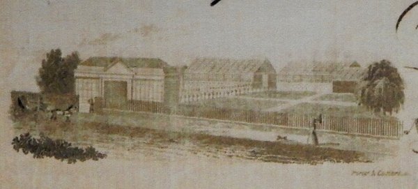
A drawing of Edward Pierce's 'Yeovil Nursery' enlarged from his bill of sale. In 1843, the date of this drawing, Pierce's house and nursery buildings were practically the only buildings along Hendford Hill - seen in this sketch as little more than a narrow lane with a lady walking her dog.
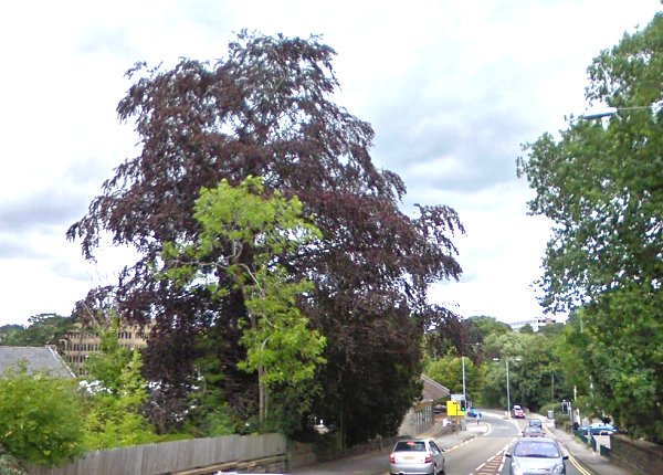
Looking north down Hendford Hill, the large Copper Beech tree at centre was planted by Edward Pierce and is a lasting reminder of his tree nursery that once covered acres either side of the road. Photographed in 2015.
From the Cave
Collection
(colourised),
Courtesy of South Somerset Heritage Collection
Swiss Cottage on Hendford Hill, photographed in the 1960s. This is Parcel 777 on the 1842 map above. The entrance to Lover's Lane is seen at right.
This
colourised
image
features in my
book 'Yeovil
- The Postcard
Collection'.
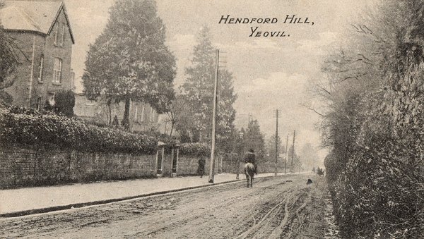
A view looking north from almost the top of Hendford Hill in a postcard of about 1910. At right the steep scrub-lined embankment was created when the gradient of the hill was altered in the nineteenth century - the original line of the road would have been almost level with the top of the embankment.
From my
collection.
This
image
features in my
book 'Yeovil
- The Postcard
Collection'.
A postcard sent in 1911. Pretty much the only thing that is different today is the volume of traffic.
Courtesy of Jack
Sweet
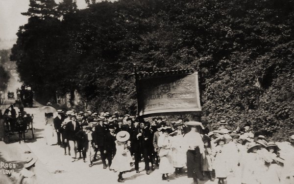
Roughly the same place, roughly the same time - the Wesleyan Sunday School children nearly at the top of Hendford Hill en route to a field where they held their summer picnic. Photographed by William Ross.
From my
collection.
This
image
features in my
book 'Yeovil
- The Postcard
Collection'.
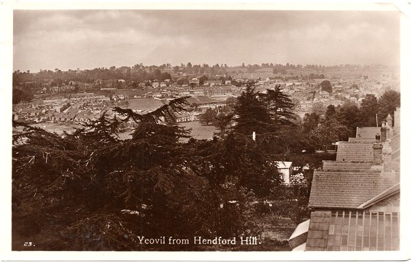
This postcard of 1934 shows that there's a good view across Yeovil from Hendford Hill - unusual for a Yeovil postcard which normally show the view from Summerhouse Hill.