Hewish (1) and (2)
Hewish (1) and (2)
Remnants of the medieval common field called Hewish Field
The great medieval field called Northover (see first map below) was later broken up and part of it became a large common field called Hewish, or Hewish Field, stretching from Ram Park in the north, the boundary with the parish of Preston Plucknett in the west, today's West Hendford in the south and roughly as far as today's Clarence Street in the east. The parcels comprising the former great common field called Hewish Field are shown shaded green in the 1842 Tithe Map below.
The name Huish, in its various spellings through time, derives from the Old English 'hiwisc' meaning a household.
On 1 July 1415 Thomas, Earl of Arundel, granted the advowson of Yeovil Rectory to Henry V with "two acres in the field called Huysh".
It was recorded that in 1611 St Leonard's Fair for rother cattle was held in "the field called Huishe in Hendford" - in this instance Hendford being the Manor of Hendford, not the road of that name. As a sidenote; the word 'rother' is an old Anglo-Saxon word for cattle. The rother cattle were long-horned, fleshy beasts prized for their meat, milk, hide and horn (see photo here).
An indenture of 1715 remarks on six acres of arable land "lying in a common field called Hewish in the tything of Hinford.... lately enclosed" - the words 'lately enclosed' being a good indication of when this common field began to be parcelled up. By the 1750s the division parcels of Hewish Field were more or less finalised as shown in the 1842 Tithe Map below.
Of these division parcels of the former common field, two parcels retained the name Hewish - Parcels 592 and 594, separated by Hewish Orchard (Parcel 593). They were bounded to the north by Ram Park (Parcel 298), to the east by In Hewish Field (subdivided into Parcels 596 to 603), to the south by cottages and gardens on the north side of Hewish Lane (today's Huish) and to the east by Willis' Orchard (Parcel 591).
Hewish
(1) - Parcel 592
The
1846 Tithe
Apportionment
noted that
Hewish (Parcel
592) was owned
by
Thomas
Binford and the
tenant was
Berkley Newman.
It was recorded
as being pasture
to graze
livestock and
measured 2a 0r
35p. As a
sidenote
Hewish
(2) - Parcel 594
The
Apportionment
noted that
Hewish (Parcel
594) was owned
and occupied by
James Beer. This
parcel was an
orchard and
measured 1a 3r
20p.
Today both the former parcels of Hewish, as well as Hewish Orchard lying between them, are covered with the houses and gardens of Carisbrooke Gardens.
For details on historic land measurement (ie acres, roods and perches) click here.
maps

This map, based on the descriptions in the 1589 Terrier and the 1846 Tithe Map of Yeovil shows the approximate boundaries of the Manors of Kingston and Hendford as well as the manorial three-field system used in Kingston.
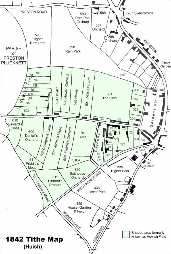
This map is based on the 1842 Tithe Map with field names added from the 1846 Tithe Award. The area shaded light green was originally a large common field called Hewish Field that had been formed out of the earlier medieval field called Northover. By the time of the 1842 Tithe Map, shown here, Hewish Field had been further sub-divided into many parcels as shown.
The two fields called Hewish are left of centre.
Map based on the 1901 Ordnance Survey showing the former Willis' Orchard completely filled with the houses and gardens of Queen Street.
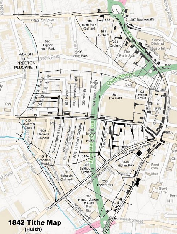
TThe 1842 Tithe Map superimposed (roughly) over a modern street map showing where several modern roads, for example the rear gardens of the eastern side of Grove Avenue, follow former field boundaries.
Gallery
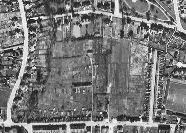
The 1946 aerial photograph clearly shows The Park and West Park running across the top of the photograph with part of Sidney Gardens seen at top right. Grove Avenue runs down the left side and Huish running along the bottom of the photograph. At right Queen Street runs north from Huish and to its west is Hewish (1) (Parcel 592) appearing to be rough ground in its northern half and allotments in the southern half. Next west is Hewish Orchard (Parcel 593) and apparently divided into three section with the southern third as allotments. Next west again is Hewish (2) (Parcel 593) apparently under cultivation and bounded on its western side by the thin white line - the access track to Huish Gardens.