The history of yeovil
yeovil at the time of the romans
Homelands of the Durotriges
 Immediately
prior to the
Roman invasion
of Britain, the
area that would
become Yeovil
was inhabited by
the
British
Celtic
Durotriges, a
loose tribal
confederation
occupying an
area from east
Devon to south
Wiltshire that
included south
Somerset and
most of Dorset.
After the Roman
conquest, their
main
civitates,
or settlement-centred
administrative
units, were
Lindinis
(modern
Ilchester, just
five miles to
the north of
Yeovil) and
Durnovaria
(modern
Dorchester).
Immediately
prior to the
Roman invasion
of Britain, the
area that would
become Yeovil
was inhabited by
the
British
Celtic
Durotriges, a
loose tribal
confederation
occupying an
area from east
Devon to south
Wiltshire that
included south
Somerset and
most of Dorset.
After the Roman
conquest, their
main
civitates,
or settlement-centred
administrative
units, were
Lindinis
(modern
Ilchester, just
five miles to
the north of
Yeovil) and
Durnovaria
(modern
Dorchester).
Initially the Roman invasion must have had little effect on the immediate area. Cadbury Castle, five miles to the northeast, was occupied by the Durotriges and was the site of vigorous resistance by them to the second Augusta Legion under the command of Vespasian during the early days of the invasion. Ham Hill, some six miles to the east, was also occupied by the Durotriges from the first century BC but were ousted by the Romans and Ham Hill became the focus of substantial occupation later in the Roman period.
The Fosse Way was a Roman road that linked Lincoln (Lindum Colonia) with Exeter (Isca Dumnoniorum) via Ilchester (Lindinis). The word Fosse is derived from the Latin fossa, meaning a ditch. For the first few decades after the Roman invasion of 43 AD, the Fosse Way was the western frontier of Roman Britain. It has been speculated that the road began as a defensive ditch that was later filled in and converted into a road, or possibly that the road ran alongside a defensive ditch.
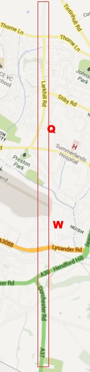
A subsidiary road ran from Ilchester to Dorchester (Durnovaria) leaving Ilchester on the line of the present A37 and then passing through present day Yeovil, shown on the map at left in a red box, on a route that took in Larkhill Road, crossing the eastern end of Westlands airfield and passing close to Rustywell then possibly dog-legging up the very steep Hendford Hill along the line of Lovers' Lane and continuing along the A37 Dorchester Road south of the town. Initially, it was close to this subsidiary road that Roman or Romano-British settlements gradually became established. The Larkhill Quarry site is marked 'Q' and the location of the Westland complex marked 'W'. It is believed that the Roman garrison troops were moved out of the area within the first hundred years of the occupation as the countryside settled down. As a sidenote, much of the southern end of present-day Larkhill Road was built by Italian prisoners-of-war in 1946.
In 1791 Collinson wrote "Roman coins and remnants of Mosaick pavements have been discovered here, and in all probability it was a town in the days of that people."
The Westland Roman complex was a major discovery in 1916 but there have been a number of other finds scattered across the area of the present town of Yeovil, listed below, suggesting the area may have supported a number of small farming communities during much of the Roman period.
-
Some Roman coins were found on the Roman road which ran along the line of Larkhill Road. The coins were exhibited at a meeting of the Somerset Archaeological Society in Yeovil in September 1853.
-
In 1856 Vickery wrote of Yeovil "some tesselated pavements and other relics discovered from time to time pointing it out as in existence in the time of the Romans."
-
Portions of four Romano-British pots were found in 1901 and 1903 by Walter Raymond, in a field adjoining the Roman road at Larkhill Road.
-
It was reported in Notes and Queries for Somerset and Dorset in 1909 that much Romano-British pottery, a few coins dating from 306 to 350 AD, other objects and a number of burials were found at Larkhill Quarry over a number of years. A pit with a 1" layer of charcoal at the bottom and many burnt stones was found. The finds occurred directly on the line of the Ilchester to Dorchester Roman road.
-
Coarse late Roman pottery similar to that from the Westland villa site was found at Penfield on the northern flank of Wyndham Hill and Roman tiles were found around 1923 during house building at Penfield as well as in a garden at Penn Mill.
-
A group of coarse pottery and a coin of Constantine II, Roman Emperor from 337 to 340 AD, was discovered near Larkhill Road in the 1920's.
-
Between Freedom Avenue and Burroughs Avenue, about 400m from the Roman Road near the Larkhill quarry site, workmen discovered a human burial containing a coin of Constantine I in the skull while digging an electricity cable trench in 1949. It is believed that the coin was placed in the mouth of the deceased so that he could pay Charon the ferryman to take him across the River Styx on his journey to the Underworld. Constantine I was Roman Emperor from 306 to 337 AD.
-
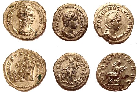
In the 1950's a denarius of Severus Alexander (Marcus Aurelius Severus Alexander Augustus, Roman Emperor from 222 to 235 AD) was dug up in a garden at Rustywell almost on the Roman road from Ilchester to Dorchester.
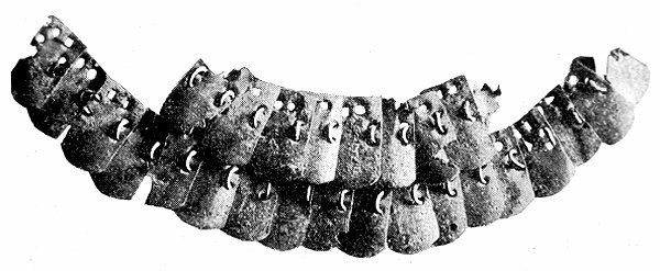
Part of a Roman lorica, or cuirass, discovered at Ham Hill. It is the finest specimen known in Britain and is now in Taunton Museum. It consists of twenty-six plates of scale armour joined together by means of rings.
The Roman coins, mainly of silver, found on the former Lower Elm Path (now part of Mudford Recreation Centre), include depictions of an elephant and a hippopotamus, animals which must have seemed exotic monsters to the Romano Britons through whose hands they passed. The hoard is thought to have been buried around 270AD.
In the early 1990s metal detectorists accumulated a collection of Roman pottery and a coin, also of Constantine I, to the east of Great Lyde Farm. Excavation of part of the site in 2009 revealed multi-period occupation, including a Romano-British component, and the following report is taken from the Somerset Historic Environment Record.
"A significant and concentrated investment in the landscape was seen in the early Romano-British period, establishing permanent ownership and occupation of the hillside. The large size of the boundary ditches suggests that they were dug by a community yet the settlement evidence indicates the presence of a smaller, perhaps family-sized, farmstead. This may suggest that the focus of settlement lay elsewhere at this time. The re-cutting of several ditches suggests a continuation of occupation by the same community. During this phase, occupation was centred on two adjacent structural features, a probable round house represented by a ring-gully and a sub-rectangular ditched enclosure. A second offset ring-gully may represent a subsidiary building. There are defined areas of activity indicative of stock control and evidence that fields were used as paddocks. Finds of fired clay, pottery, charcoal, slag, loom weights and quern stone are typical of traditional occupational and subsistence activities.
The Romano-British period represents a substantial episode within the landscape development of the site and is predominately characterised by a wide-scale sub-division of the land for agricultural purposes. A transition from a predominately pastoral to a predominately arable environment is implied with settlement moving beyond the limits of the current excavation boundaries. However, the recovery of occupational debris from the field ditches does suggest this settlement did not move far. On the periphery of the settlement were small-scale industrial (metalworking) foci and the lower slopes of the hillside appear to have reverted to unenclosed grazing land. The field ditches were maintained and gradually embellished.
In the late 3rd century there is evidence that coin forging was being carried out, in the form of moulds for copying coins of the emperor Carausius. Subsequent activity on the site was very limited, few artifacts dating to the 4th century were found and no new features were dug. The site seems to have been largely abandoned by the mid-4th century."