Pen Hill
Pen Hill
The greater part of today's Wyndham Hill
The word 'Pen' comes from the Celtic word for a hill, found most frequently in Cornish and Welsh place names. Today's Wyndham Hill was formerly known as Kingston Pen, or Pen Hill (not to be confused with Yeovil's other Penn Hill which still retains the name although retaining the double letter 'n'), and the 1589 Terrier referring to part of today's Sherborne Road describes it as running along ".... the north side of Kingston Penne.... ".
Below is shown the notice of the annual letting of Pen Hill and Pen Field (which had traditionally been a separate field lying on the northwest slopes of the hill) from the Taunton Courier's edition of 19 August 1829, by which time both fields had been subdivided into several smaller parcels. At this time it was owned by Thomas Tytherleigh, Gent., of Norton Fitzwarren. For the complex ownership see the page of his younger brother who occupied it, brewer and baker Robert Tytherleigh of Pen Mill. After Robert's death it became part of the Newton Surmaville estate and was owned by the Harbin family.
In referring to today's Wyndham Hill, the 1846 Tithe Apportionment recognised the following parcels of land, all of which were owned and occupied by George Harbin unless other wise stated below -
Parcel 851 -
Victoria Hill
Victoria Hill
was recorded as
pasture for
grazing
livestock
measuring 13a 1r
30p. The tenant
was William
Pope. It remains
today as open
grassland.
Parcel 852 -
Plantation
Today mainly a
scrubby woodland
hillside which
rises steeply
above Railway
Walk, being too
steep for any
other purpose,
was a plantation
intended for
timber. It
measured 1a 1r
30p.
Parcels 853 and
853a - In Pen
Hill
The
northern slope
of Pen Hill,
today covered by
houses and
gardens of the
south side of
Sherborne Road
and the Beaumont
House flats, was
recorded as
pasture and
orchard
measuring 4a 0r
20p.
Parcel 854 - Pen
Hill
The northeastern
section of the
hill from the
summit to
Sherborne Road
and spanning the
corner of the
hill facing from
halfway between
St Michael's
Avenue and Lyde
Road to opposite
the Pen Mill
Hotel. It was
recorded as
measuring 8a 2r
16p and was used
as pasture for
grazing
livestock, as it
is today,
although much is
now covered with
the houses of
Wyndham View.
Part of it was
at one time
occupied by the
Vita Ray Laundry.
Parcel 855 -
Higher Pen
The southern
flank of the
hill running
down from the
summit to the
Pen Mill
millstream. It
was recorded as
measuring 7a 0r
15p and was used
as pasture for
grazing
livestock, as it
remains today.
Parcel 856 -
Lower Pen
The extreme
eastern flank of
the hill running
down from the
summit to Pen
Mill. Also used
as pasture, as
it remains
today, it was
recorded as
measuring 7a 0r
15p.
.... and some of the smaller parcels adjoining Sherborne Road
Parcel 518 -
Cottages &
Garden
Originally part
of Pen Hill, in
1846 this was
owned by George
Ellis and
occupied by
William Phelps.
It measured 0a
3r 6p and was
noted as "Arable
etc."
Parcel 519 - Old
Nursery
This parcel, the
Old Nursery, was
owned by Rebecca
Eason and
occupied by Joel
Hardy. The Tithe
Apportionment
recorded it as
1a 0r 0p and
noted it as
"Arable etc."
Parcel 520 -
Withey
Bed
Owned by George
Harbin, the
tenant was James
Fox. It measured
0a 1r 36p and
was recorded as
'Wood'.
Parcel 521 - Brewery
& Garden
This was the
brewery,
malthouse,
bakery and shop
originally run
by Robert
Tytherleigh,
mentioned above.
In 1846 it was
owned by James
Ellis and
occupied by
William Phelps.
It was recorded
as "Arable etc."
and measured 0a
1r 26p.
For a general overview of Wyndham Hill click here
For details on historic land measurement (ie acres, roods and perches) click here.
maps
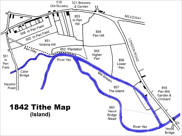
This map is based on the 1842 Tithe Map with field names chiefly added from the 1846 Tithe Apportionment.
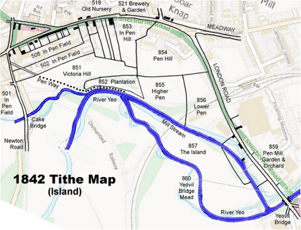
The 1842 Tithe Map superimposed (roughly) over a modern street map. Bearing in mind the relatively primitive surveying equipment of the 1840s they weren't all that far out.
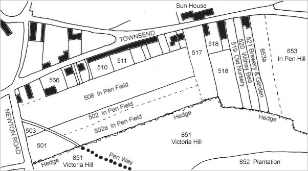
Again based on the 1842 Tithe Map, this enlarged view shows the various parts of eastern Pen Hill that had been sub-divided and sold off as described above.
Gallery
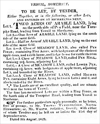
The notice of the annual letting of Pen Field and Pen Hill (in all their various parts) from the Taunton Courier's edition of 19 August 1829.
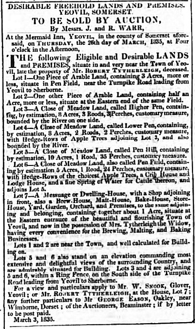
Notice of the 1835 sale of both Pen Field and Pen Hill after the death of Robert Tytherleigh.
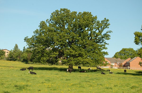
Parcel 851 - Victoria Hill
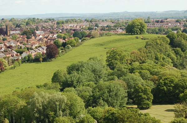
The western flank of Wyndham Hill seen from Summerhouse Hill. In 1846 the greensward running from Newton Road to the trees at the summit of the hill was known as Victoria Hill. Photographed in 2013.
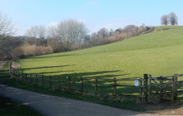
Parcel 852 - Plantation
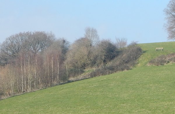
The eastern end of the Plantation seen from Railway Walk. Photographed in 2016.
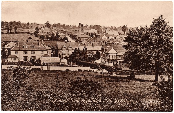
Parcel 853 - In Pen Hill
From my
collection
The photograph of this postcard was taken in 1913 from the top of Wyndham Hill. Across the centre of the photograph are the houses of Sherborne Road, at centre top is St Michael's church. The trees at right mark the boundary between In Pen Hill (Parcel 853) to the left of the trees, and Pen Hill (Parcel 854) to the right of the trees.
Parcel 854 - Pen Hill
Pen Hill is still used as pasture for grazing livestock. Photographed in 2013.
Parcel 855 - Higher Pen
Higher Pen seen from the northern end of Railway Walk. Photographed in 2016.
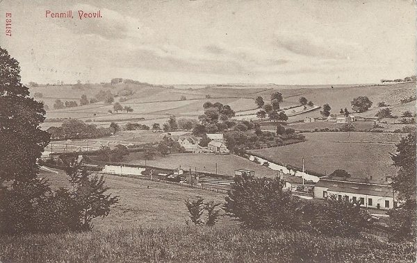
Parcel 856 - Lower Pen
From my
collection
A postcard of about 1910 looking southeast and showing Pen Mill at centre. At bottom right is the Pen Mill Station engine shed and the signal box just below and to the left of the mill at centre. Between the engine shed and the mill is the mill stream and the Sherborne Road runs from just above centre left to the mill. Pen Mill Station is off image to the left. The photograph was taken from today's Wyndham Hill and Lower Pen is the field seen between the bushes at lower left of centre, the near side of the railway.
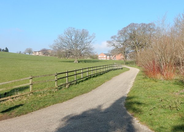
Lower Pen photographed in 2016 from the northern end of Railway Walk. Sherborne Road is off-photo to the right, running alongside the trees and bushes and Wyndham Hill is off photo to the left. The footpath seen here runs west to join Sherborne Road close to the Pen Mill Hotel.