Pen Field
Pen Field
Formerly part of the Newton Surmaville estate
In earlier times Pen Field was a very large field, partly bisected by Pen Way, occupying the northwestern slopes of today's Wyndham Hiil alongside Sherborne Road and stretching from Newton Road to Hillside Terrace.
The site appears to have been settled by the Romans since coarse late Roman pottery similar to that from the Westland villa site was found at Penfield and Roman tiles were found around 1923 during house building at Penfield.
The earliest recorded reference to Pen Field, albeit somewhat later than Roman times, was in the 1659 Quarter Sessions Roll which recorded "Five hemp shoates stolen from Thomas Francis's Pennfield". A 'shoate' was, presumably, a sheaf or bundle of hemp and gives a clue as to the crop grown on the hill at that time - the flax industry flourished in and around Yeovil until the middle of the twentieth century.
In his will of 1736 (proved in 1741), Jeremiah Hayne wrote "... my Dwelling House called the Sun and the Close or parcel of Land behind the same and one acre of arable Land in Penfeild ...".
Below is shown the notice of the annual letting of Pen Field and Pen Hill from the Taunton Courier's edition of 19 August 1829, by which time both fields had been subdivided into several smaller parcels. At this time it was owned by Thomas Tytherleigh, Gent., of Norton Fitzwarren. For the complex ownership see the page of his younger brother who occupied it, brewer and baker Robert Tytherleigh of Pen Mill. After Robert's death it became part of the Newton Surmaville estate and was owned by the Harbin family.
By the time of the 1846 Tithe Apportionment Pen Field had been subdivided into several smaller parcels of land (many of which had been sold off), with that alongside London Road (today's Sherborne Road) being built up at an early date. An enlarged view of Pen Field is shown below, the owners, occupiers of the several parcels as at 1846 were as follows -
Parcel 501 - In
Pen Field
Owned and
occupied by
George Harbin of
Newton
Surmaville.
It measured 0a
1r 17p and was
arable, used for
growing crops.
Parcels 502 &
502a - In Pen
Field
Both parts owned
and occupied by
George Harbin.
Measuring 1a 0r
0p in total, it
was also arable.
Parcel 503 - Garden
Owned by Mary
Marshall and
occupied by Joel
Hardy. It
measured 0a 0r
10p.
Parcel
508 - In
Pen Field
Also owned by
Mary Marshall
and occupied by
Joel Hardy. It
measured 2a 3r
35p and was also
arable. The
western end
eventually
became the site
of the old
Western Gazette
offices and the
Aplin & Barrett
factory.
Parcel
517 - In Pen
Field
The easternmost
of the small
parcels of the
former Pen
Field, owned and
occupied by
George Harbin it
was listed
'Gardens', used
as arable and
measured 0a 1r
25p.
Parcel
566 - Cottage
and Gardens
Owned by
William Jones
Prowse, Lord
of Kingston
Manor, the
tenant was
Thomas Holt. The
plot measured 0a
2r 31p.
Today the former Pen Field is completely filled with a mix of housing, offices, and commercial buildings.
For details on historic land measurement (ie acres, roods and perches) click here.
maps & Aerial photograph
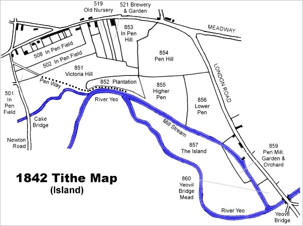
This map is based on the 1842 Tithe Map with field names chiefly added from the 1846 Tithe Apportionment.
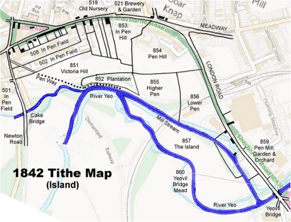
The 1842 Tithe Map superimposed (roughly) over a modern street map. Bearing in mind the relatively primitive surveying equipment of the 1840s they weren't all that far out.
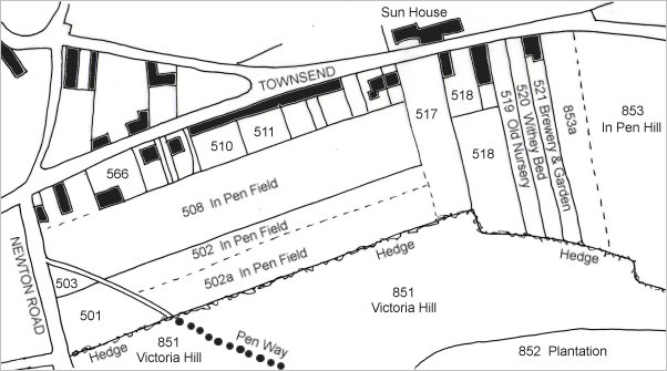
Again based on the 1842 Tithe Map, this enlarged view shows the various parts of Pen Field after being broken up into several smaller parcels.
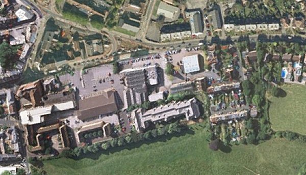
The 2016 aerial photograph of the former Pen Field showing it completely filled today with a mix of housing, offices, and commercial buildings.
Gallery
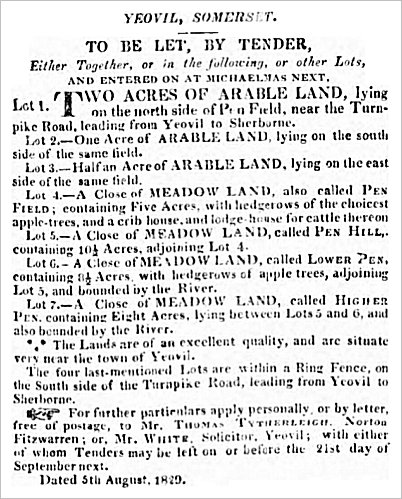
The notice of the annual letting of Pen Field and Pen Hill (in all their various parts) from the Taunton Courier's edition of 19 August 1829.
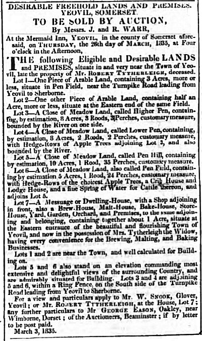
Notice of sale of both Pen Field and Pen Hill after the death of the owner Robert Tytherleigh who had established his brewery adjoining London Road (today's Sherborne Road) on the lower slopes of Pen Field.
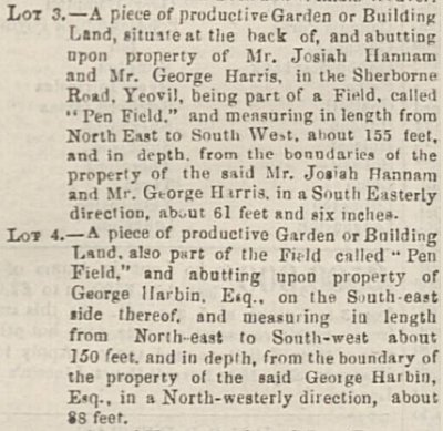
An advertisement in the 6 October 1863 edition of the Sherborne Mercury which included two lots in a larger sale that were parts of Pen Field. At the time of the sale both parcels were owned by George T Hardy of Lyde Villa.
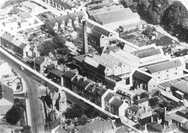
This interesting aerial photograph, probably taken during the early 1960s, shows the junction of Reckleford and Sherborne Road at lower left with Townsend running along to bottom right. The house at the junction (now a pedestrian / flowerbed area) is at lower left, the Duke of Wellington at lower right and the industrial units between the Sherborne Road houses and Wyndham Hill at top right. Pretty much everything seen in this photograph except the lower left quadrant was built on the former Pen Field.
Courtesy of
Chris Rendell
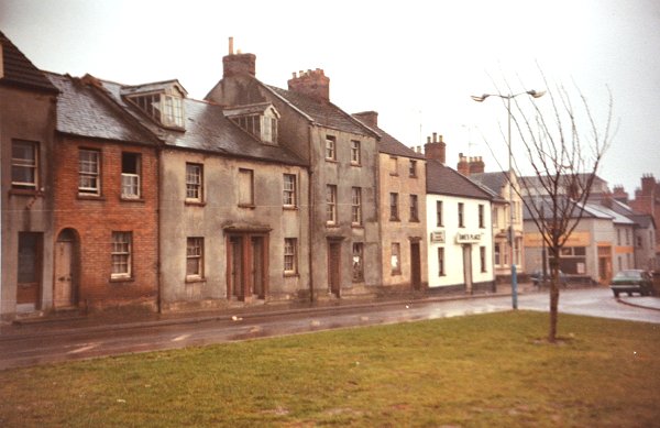
These houses were the first to be built along the south side of Townsend and seen on the 1842 Tithe Map above. Photographed in 1983 shortly before their demolition.