THE TRUMPET alehouse
PUBS HOME PAGE |
PUBS INTRODUCTION |
PUBS BY NAME |
BEERHOUSES |
TRUMPET
Rackleford (now Market Street)
|
There is only one reference to a public house called the Trumpet (marked as 'A' on the map at right) and that is in a 1769 Conveyance as shown in the documentation below. Leslie Brooke, in his notes, wondered if the Trumpet could have been an early name for the Pall Tavern. However it couldn't possibly have been the Pall Tavern for one simple reason - the conveyance documented below clearly states that the Almshouse was to the south of the waste ground (coloured green on the map) being conveyed and the Trumpet was on the east of the waste ground, making the Trumpet north and east of the Almshouse, whereas the Pall Tavern is known to have been to the west-southwest of the Almshouse. |
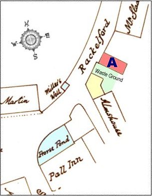 Map based on E Watts' map of 1828 |
documentation
| 1769 |
James Upton, gentleman, of Yeovil, to William Daniell, gentleman, of Yeovil - Piece of waste ground whereon formerly stood a dwellinghouse lately pulled down, bounded on the east by a public house called the Trumpet, on the south by the Almshouse, on the west by a dwellinghouse in possession of William Winter (yellow on my map); on the north by the highway leading from Reckleford to the Borough; now in the possession of James Upton. 12 July 1769 |