combe street
combe street
An ancient field now part of the Pitch & Putt course
The field named Combe Street (Parcels 1092 and 1093) was originally part of the great Middle Field of Kingston Manor. In describing the boundaries of the Middle Field, the 1589 Terrier refers to "In Thos Phelps's Close called Coomstreet". An enrolled deed dated 1613 refers to "Two closes of arable land called Combstrete."
A 'bargain and sale' dated 3 January 1670/1671, held in the Somerset Heritage Centre at Taunton, by Thomas Whippye the elder of Kingston juxta Yeovil, glover and Samuel his son to John Cary of Yeovil, mercer, of two ac[res] of arable land in the Middle Field of Kingston juxta Yeovil, one lying in Bramble Furlong with the land of William, Lord Stowerton, in the possession of Joseph Monkton on the north and the land of John Cary on the south, and the other abutting Combestreet Furlong. Consideration £2
Combe Street (Parcels 1092 and 1093) was bounded to the north by Combe Street Lane, to the west by Higher Elm Path (1094), to the east by Hutt Field (1089), and to the south by Stoney Field (1087 and 1088).
In his will dated 1813, John Ryall bequeathed Combe Street to his grandson John Ryall Mayo, the future first mayor of Yeovil.
The 1842 Tithe Map shows Parcel 1095 as a thin strip (not shown on my map below) called Combe Street Plot - a thin wooded verge alongside Combe Street Lane. The 1846 Tithe Apportionment recorded Combe Street as being owned by Henry Goodford of Chilton Cantelo and the tenant was John Newman Berkley. The area was recorded as 5a 2r 0p and noted as pasture, next to the wooded verge.
On 30 August 1849 Henry Goodford Esq. of Chilton Cantelo, leased to baker Nathaniel Bartlett of Yeovil, the following parcels of land, Land late in occupation of Mr John Newman-Birkley in Yeovil for £172. 10s -
-
a cottage and garden Hundred Acres - 3a 2r 20p
-
Stoney Field and Green Close - 8a 2r 10p
-
Higher Elm Path - 7a 2r 12p
-
Middle Elm Path - 8a 3r 35p
-
Lower Elm Path - 7a 1r 20p
-
Coombe Street - 5a 2r 10p
-
Beacon - 16a 2r 10p
-
Total 58a 1r 26p
Today the western third of Combe Street forms the northern part of the Pitch & Putt course of Yeovil Recreation Centre, affectionately known as 'Mudford Rec', and remains part of the only open green area in the Hollands section. The remaining two-thirds of the former field were built on after the Second World War with the cul-de-sac off Combe Street Lane to the immediate west of Combe Close.
For details on historic land measurement (ie acres, roods and perches) click here.
map

This map, based on the descriptions in the 1589 Terrier and the 1846 Tithe Map of Yeovil shows the approximate boundaries of the Manors of Kingston and Hendford as well as the manorial three-field system used in Kingston.
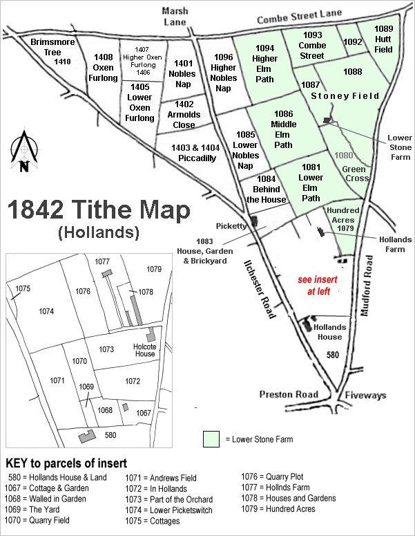
The Hollands area reproduced from the 1842 Tithe Map. Combe Street is top right.
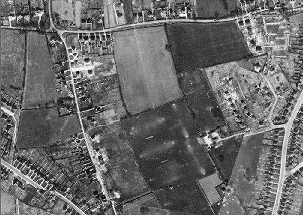
The 1946 aerial photograph showing Combe Street as the large rectangular field at top right. At this stage it was not built on - the building works seen to its right was Combe Close under construction.
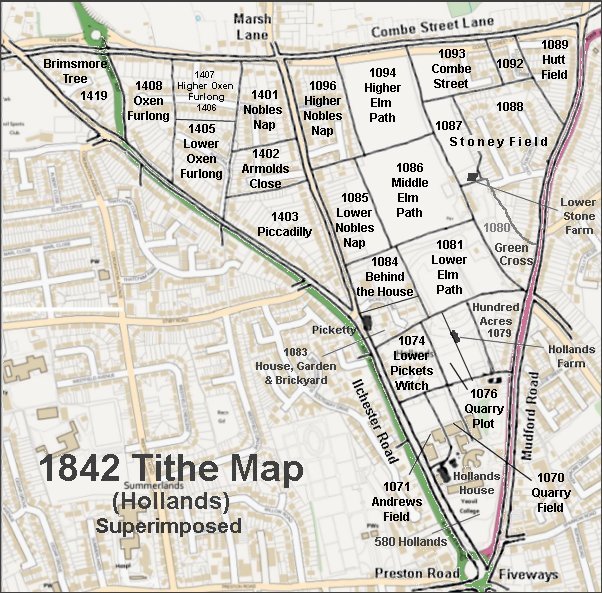
The 1842 Tithe Map superimposed over a modern map.
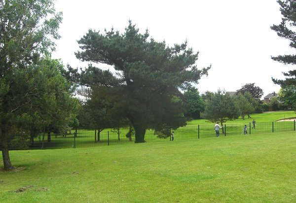
Combe Street today, as the northern section of the Pitch & Putt course, seen from the northeast corner of Higher Elm Path. Photographed in 2014.