town gasworks
town gasworks
Middle Street
"In 1830 King William the Fourth came to the throne and it was celebrated in Yeovil by a grand and general illumination. gasworks were being erected there and the gas was let into the town from the works for the first time on that day (26 June) and it was the first time I had seen gas and I remember some of the designs were very beautiful. A young man, a Mr Llewellyn was the Gas Engineer who erected and after managed, for a time, the works. He was a Wesleyan and a local preacher, he was very popular, he entered the ministry and 'ere he died he became president of the 'Old Body'." (From the diary of Edward Ensor (1821-1905)).
The Town gasworks, off Middle Street, were built by the Yeovil Gas & Coke Company and completed in 1833 on the site of a drained withy bed. Complete with retorts and gas holders, by 1856 it was producing 28,000 cubic feet of gas daily and supplied gas to the Corporation's 124 street lamps. The newly-elected Improvement Commissioners had initially provided 160 oil-burning street lamps in the town but these were converted to gas from 1834.
In 1856, Daniel Vickery wrote "Previous to the year 1834, the streets of Yeovil were lighted with oil, there being about 120 lamps, at an expense of about £135 a year. A private Company, neither registered nor incorporated, was established in 1833, with a capital, in shares of £30 and £10 each, amounting to £3,500. In 1853 the capital was increased to £5,600. Under the powers of the Town Act, the Commissioners conceded to the Company the right to lay mains under all the streets. The works are situated in the lower part of the town, near the Newton turnpike gate. There are two gas holders, holding collectively 28,000 cubic feet, and premises for 11 retorts. The pipes are laid under every street in the town. There are 124 lamps, which, according to an agreement recently made with the Town Council, are for the future to be lighted from the 16th August, instead of the 1st September, to the 1st May. Sixteen lamps are kept lighted till four in the morning; each lamp costs the town 48s 6d per annum. The whole cost of lighting exceeds £300 annually. The consumption of gas for private purposes averages, in winter, daily, about 10,000 cubic feet; in summer about 1,200. The factories consume a good deal. The cost of land, buildings, mains, lamps, &c., &c., amounted to £5,553 15s 9d."
In the 1851 census 55-year old John Bunn was listed as the Manager of the gasworks and lived there with his wife, Frances, and their five children. In the 1871 census the Gas Manager was 25-year old John Ball from Loughborough, Leicestershire who lived there on his own.
The enterprise was eventually acquired by the Corporation itself, under a local Act of Parliament in 1899, and continued to illuminate the town until the close of the Second World War.
The gasworks closed in 1957 and the site cleared in the early 1970s.
MAPs & Aerial photograPH
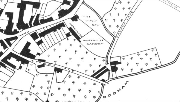
Map based on Watt's map of 1831 showing Yeovil's first workhouse off Lower Middle Street. The stream running past the withy bed and then alongside part of Dodham Lane was the combined Rackel Brook and Milford Brook. The future gasworks eventually stretched from the withy bed as far as Stars Lane.
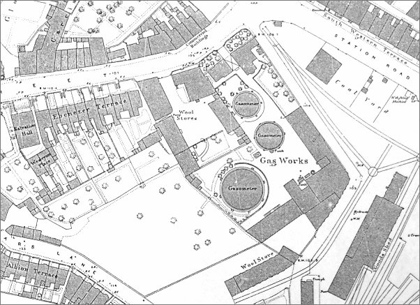
The 1886 Ordnance Survey shows the location and size of the gasworks at this time.
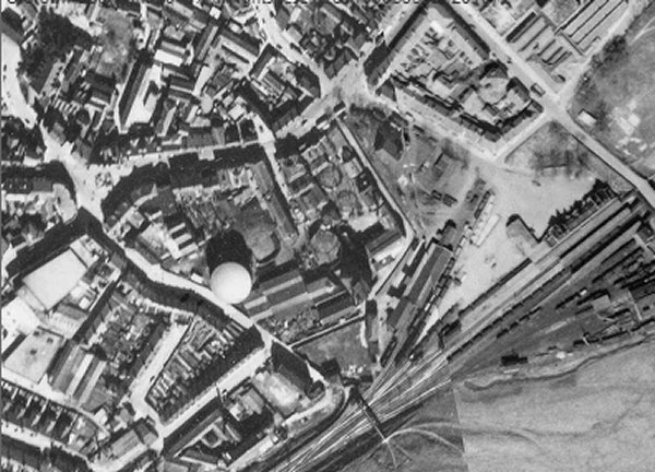
This 1946 aerial photograph shows the gasworks, at centre, which had by this time extended as far as Stars Lane next to the new, large gas holder just left of centre. The right-hand side is occupied by Yeovil Town railway station.
gallery

A nice piece of ephemera - the annual gas bill for the almshouses dated Lady Day (25 March) 1869 in the sum of £2 1s 3d (about £190 at today's value).
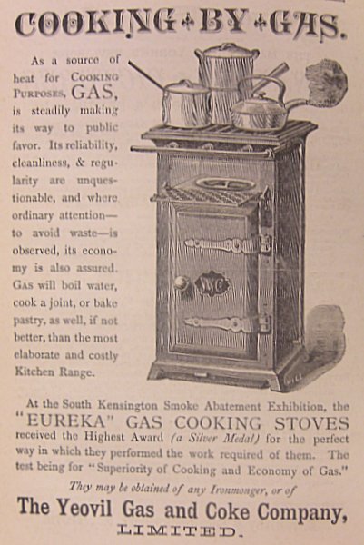
An advertisement by the Yeovil Gas and Coke Company for a trendy new gas cooker in Whitby's Yeovil Almanack Advertiser of 1885.
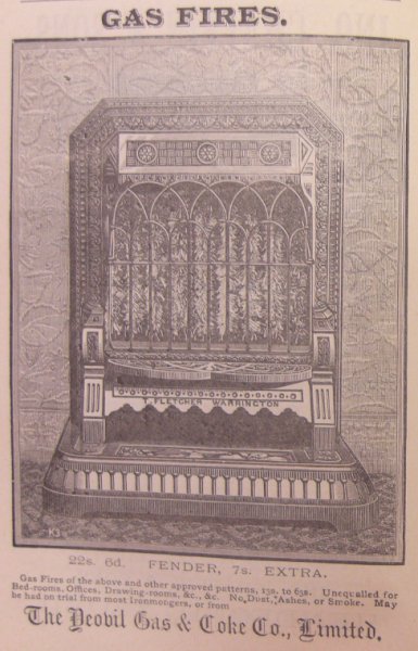
An an advertisement for a gas fire in the 1888 edition of Whitby's Yeovil Almanack Advertiser.
This
photograph
features in my
book 'Yeovil From Old Photographs'.
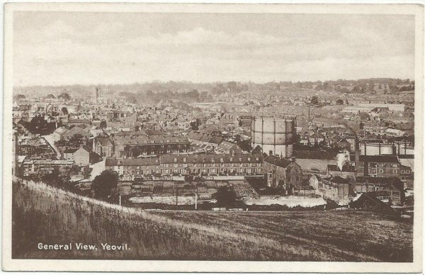
This postcard, taken from Summerhouse Hill, dates to about 1905 and shows Talbot Street at centre, behind the row of houses in Summerhouse Terrace. At the left end of this terrace is the entrance to Talbot Street. At right, the gas holder was next to Stars Lane, the houses of which are seen between the gas holder and Talbot Street. Below the gas holder is the Foundry House leather glove factory before its extension was built at the rear.
Courtesy of
Colin Haine
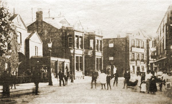
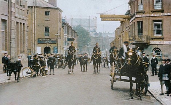
Middle Street, circa 1905. At left are the gasworks offices, at centre the Liberal Hall and to the right are the offices of the Western Chronicle. Taken from a newspaper cutting.
From my
collection
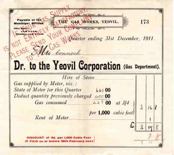
In 1899 the gasworks was taken over by Yeovil Corporation who, from this time, issued their own demands. This bill is from 1911 (I wish my quarterly bill was this low).
Courtesy of
George Hallett
-
This
colourised photograph
features in my
book 'Yeovil From Old Photographs'.
By 1918, the date of this Rendell photograph, the former Western Gazette offices were being used as a Salvation Army Temple. Note the gas holder dominating the view into town.
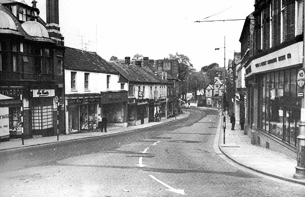
Looking down Lower Middle Street, remarkably traffic-free in the 1950s. At right is the Yeovil & District Co-operative Society's furniture branch store. At the far end is the office building of the Town gasworks.
This
photograph
features in my
book "Lost Yeovil"
The offices, and originally accommodation for the gasworks manager and his family, facing Middle Street and built in 1833 - photographed from Central Road in the 1960s.
This colourised photograph, taken around 1960 from Central Road, is looking across Middle Street with the junction of Station Road (now Old Station Road) at extreme left. Right of centre the three-gabled building was the Town Gas Works offices, originally also accommodation for the Gas Works Manager and his family, (now, after an art deco makeover in the 1970s, converted to the shop of St Margaret's Somerset Hospice). At extreme right the building with the 'Middle Street Centre' sign was the earlier Railway Inn, now the site of the William Dampier. The entrance to Gas Lane was between the two trees at left, the site is now occupied by the former Key Markets House, later (2014) converted to a Premier Inn.
Courtesy of Olly
Ewens
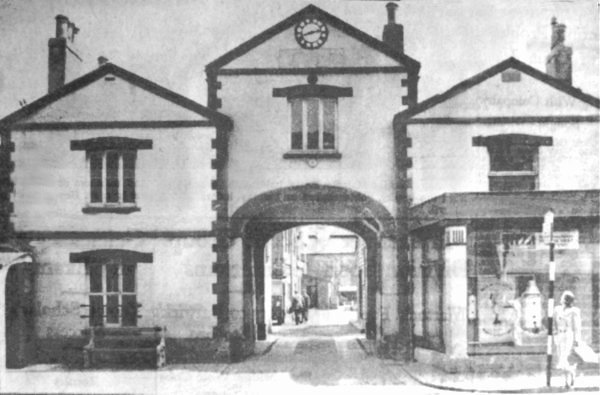
Reproduced from a newspaper of 1957. The caption read "A view of the frontage of the Gas Board premises in Middle Street, Yeovil, which will continue in use as showrooms etc. when the gasworks at the rear close down in June."
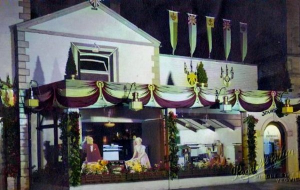
An unusual night-time view of a 1960s window display in the gas showrooms.
This
colourised photograph
features in my
book "Lost Yeovil"
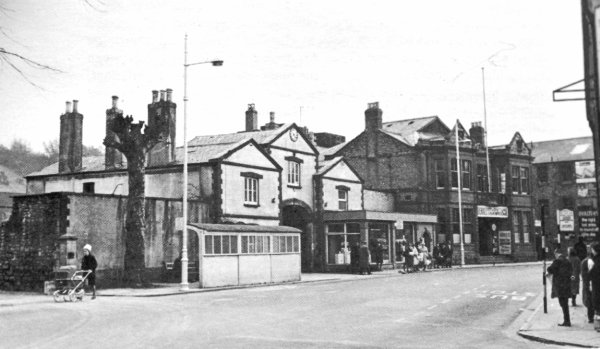
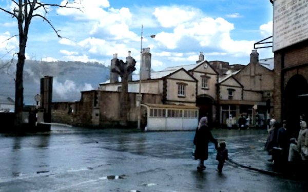
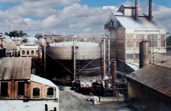
The gasworks photographed in the 1950s.
This image looking down Stars Lane shows Albion Terrace at right and the gasholder at left.
Taken from the very bottom of Stars Lane, looking north, with Foundry House at left and the gas works at right.
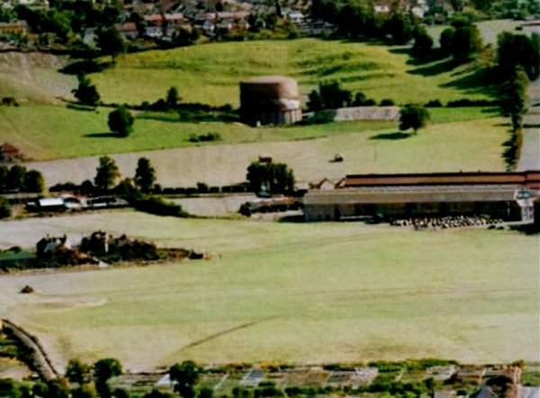
.... and now for something completely different - the Lysander Road gas holder (before Lysander Road was even thought of) in a colourised photograph of 1953. Westland airfield covers the lower half of the photograph with the start of the factory buildings at centre right.
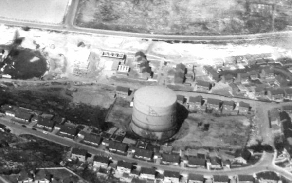
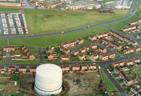
An aerial photograph of the gas holder near Lysander Road (running across the top of the photo). Photographed during the late 1960s or early 1970s.
Colourised photograph by
Geoff Bowler,
courtesy of Sue
Bowler
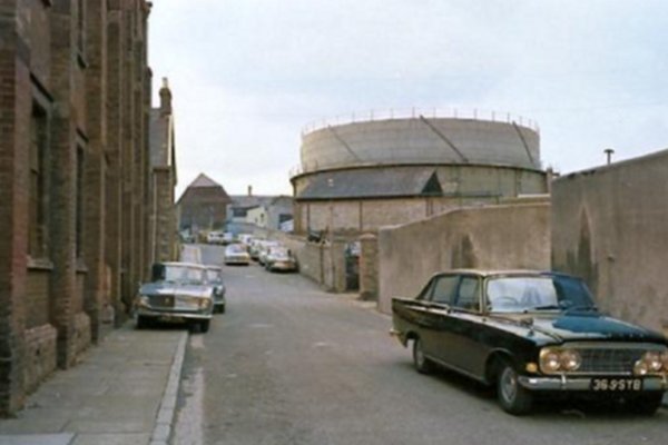
The Lysander Road gas holder, photographed in 1969.
Courtesy of
Michael Ottewell. This
photograph
features in my
book "Lost Yeovil"
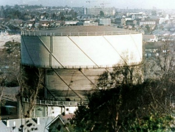
And seen again during the early 1980s. Note the single carriageway Lysander Road running across the top of the photograph.