The rackel stream
the rackel stream
An early Borough boundary, later open sewer
 In
mediaeval times
much of the
northern
boundary of the
Borough was a
small stream or
brook called the
Rackel, or
Rackle. The name
derives from the
Old English word
'racu'
meaning a
water-course.
In
mediaeval times
much of the
northern
boundary of the
Borough was a
small stream or
brook called the
Rackel, or
Rackle. The name
derives from the
Old English word
'racu'
meaning a
water-course.
The Rackel ran across the road, now the junction of today's Silver Street and Market Street, where there was a shallow ford. Indeed, in a document of 1355, today's Market Street was referred to as Ford Street. This ford across the Rackel led to Ford Street becoming known as Rackleford, or Reckleford, not to be confused with today's Reckleford which in earlier times was known as Reckleford Hill.
The source of the Rackel was close to Kingston and a lease dated 24 July 1759 between George Prowse of Yeovil, Esq., and William Daniell the Younger of Yeovil, Glover, refers to "A piece of ground at Court Ash on the north side of the highway running up to the brook that runs from Kingston to the Horse Pond in Yeovil measuring 300ft long and 3ft wide with full liberty of William Daniell to erect a wall and take the water course into and through his own garden."
The water table was relatively shallow here and two wells were located either side of the Rackel; Nun's Well in Silver Street on the corner of North Lane and Miller's Well situated on the western side of Market Street close to the Rackel. In 1852 in his Report to the General Board of Health concerning, among other items, Yeovil's water supply, Thomas Rammell wrote "The well or spring in Reckelford (Miller's Well), gives a small supply of very pure water. It finds its way from under the side of the rock, or limestone strata. The well at the Church Steps (Nun's Well) is under similar circumstances, that is, the water finds a passage between the rock and the compact indurated clay, marl, etc. immediately beneath it." and it is likely that a similar occurrence was the source of the Rackel Stream.
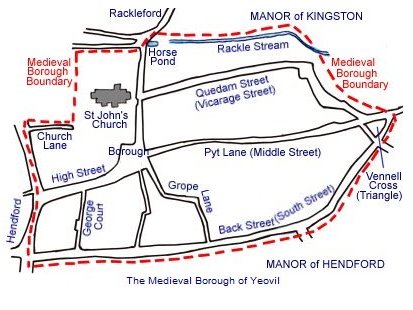
Alongside the Pall Tavern was a pond called the Horse Pool into which the Rackel ran, and then out the other side to continue eastwards. At this point the Rackel became the Borough boundary. It gradually turned south-east, crossing Middle Street roughly where the Liberal Club is today, before running running into a small, waterlogged field called the Withy Bed and then filtering east to join Milford Brook which, in turn, flowed into Dodham Brook.
Where the Rackel Brook and/or Milford Brook crossed Fore Street, as that part of Middle Street from the Triangle to Central Road was known at the time, there was a bridge - mentioned in the 1589 Terrier ".... from Forestreet bridge to Penneway...." and "from thence to Forestreet bridge".
Even until the middle of the nineteenth century there was no modern sewerage system in Yeovil and it is recorded that five feet deep open ditches, euphemistically called 'sewers ', ran alongside most streets, including the Rackel which by this time was no better than an open drain running from the Pall Tavern to the town gasworks.
This open sewer was still extant in 1849 when a government report commented that Yeovil was "a very filthy, a very dirty and a very stinking place". The Rackel was finally culverted during the 1850s following the report.
Today the Rackel is one of Yeovil's 'lost' streams (see also Milford Brook). It still runs underground and can occasionally be heard running at a road gully opposite the Pall Tavern.
MAP
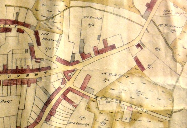
Edward Bullock Watts' map of 1806 shows the Rackle running across the top of the map, passing under Middle Street and petering out into parcel 678 (called the Withy Bed) at top right. Middle Street runs from centre left to top right and Starrs Lane is bottom right. At centre right Parcel 677 is the 'new' Workhouse with the Workhouse Garden below and to the right. Milford Brook is seen running down the right edge of the map, where it joined Dodham Brook, just glimpsed in the bottom right corner.