miller's well
miller's well
Rackleford
Miller's Well was a public well (Yeovil didn’t have mains water until the middle of the nineteenth century) situated near the corner of Court Ash and Rackleford (today's Market Street). Miller's Well was in the manor of Kingston while the Nuns' Well, just yards away, was in the manor of Hendford.
Miller's Well is mentioned as early as 1357 in a deed as 'Milewardiswill' thus "Covenant between John de Rysyngdon, parson of the church of Ievele, and John Westekota and Matilda his wife, relative to a messuage and curtilage next Milewardiswill in Kyngeston. Sixth of the Kalends of May, 30 Edward III".
It was mentioned again as ‘la Mulewardeswell’ in 1367 in a lease agreement between Sir Edward Courtenay and William Hopere for “cottages and land abutting on to the street leading to la Mulewardeswell”.
In the Churchwardes' Accounts of 1568 are recorded payments totaling 7s.7d. for putting Myllars Well in good repair and in 1748 there is an entry noting the payment of 2s for "Opening the Millers well Gutter".
The Survey of Kingston noted in 1633 "Richard Batchiler holds by copy granted 13 Apr 1609 by Edward lord Stourton the reversion of a dwelling house called Mileres Well."
Edward Bullock Watts' 1806 map of Yeovil, shown below, locates Miller's Well on the northwestern side of Rackleford in the area where today is
In 1852 in his Report to the General Board of Health concerning, among other items, Yeovil's water supply, Thomas Rammell wrote "The well or spring in Reckleford (Miller's Well), gives a small supply of very pure water. It finds its way from under the side of the rock, or limestone strata. The well at the Church Steps (Nun's Well) is under similar circumstances, that is, the water finds a passage between the rock and the compact indurated clay, marl, etc. immediately beneath it."
In 1851 there were one hundred and thirteen wells and pumps in Yeovil. Other than Miller's Well, the principal wells of the town were Dick's Well and Rustywell, both in Hendford, Nuns' Well in Silver Street, Bide's Well in Kingston, Cave's Well in Princes Street, Turner's Well and Hannam's Well both in High Street, and the Gasworks Well. But, to quote Vickery "Several wells in the town are contaminated by the soakage from private sewers, deposit of offal, refuse of skins, and other filth."
In earlier times, maintenance of the town's wells was often paid for by donations from the townspeople. For example, in Alice Lane's will of 1655 she wrote "Item I give towards the repairings of the Well in Kingeston five pounds which doth lye in John Moores hands".
map
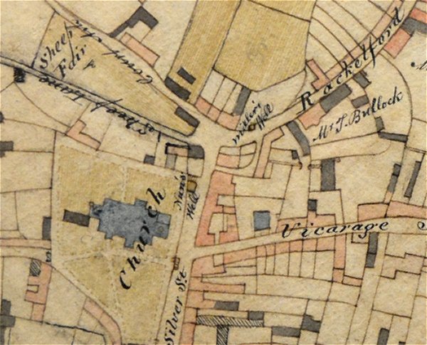
Edward Bullock Watts' map of 1806 showing the location of Nuns' Well at centre and Miller's Well above and to its right. Note that the buildings on the corner of Silver Street and Sheep Lane (today's North Street) are not Church Terrace which was built later.
Gallery
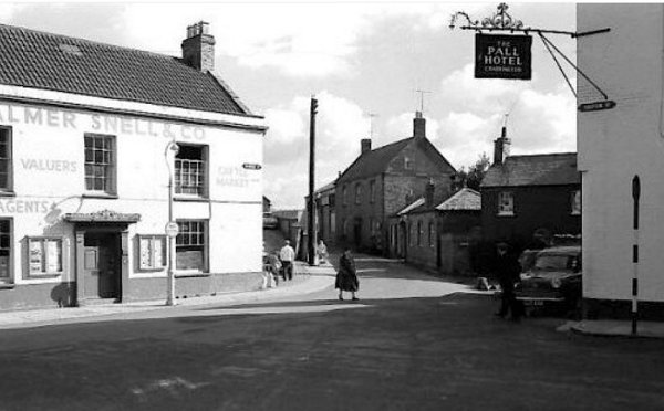
Market Street photographed in the 1960's from Silver Street with Court Ash House at left. The location of Miller's Well was about where the man in the white shirt stands.