Milford Lane turnpike side gate
Milford Lane turnpike Side Gate
Plugging a gap before 1859
In 1753, Turnpike Commissioners were appointed for "repairing and widening the roads" of Yeovil. At the first meeting of the Yeovil Turnpike Trust on 12 June 1753, they ordered that "three capital gates be erected" at Hendford Bridge (by today's Railway Tavern) and also known as Hendford Gate, Goar Knap (spanning Sherborne Road on the town side of the junction of St Michael's Avenue - later replaced by Yeovil Bridge Turnpike House) and the "Head of Kingston". There was also the Pen Style Stop Gate near the entrance leading from Pen Style to Newton, later replaced by Pen Style Turnpike House. Other gates at various times being Watercombe Side Gate, Combe Street Lane "Hutt Gate" - later replaced by Mudford Road Turnpike House, Milford Lane Side Gate (today's Goldcroft) and Jernegan's Hut Side Gate at Vagg.
 |
Edward
Bullock
Watts'
1806 map
of
Yeovil
(extract
at left)
shows
today's
Goldcroft
from
Reckleford
to
Milford
Cross
and
beyond
was
bounded
for its
entire
length
by
fields
with no
houses
whatsoever.
At this
time it
was
called
Gold
Croft
Lane,
but only
about as
far as
today's
Crofton
Avenue,
after
which it
was
called
Milford
Lane
(the top
two
thirds
at the
top of
this map
extract).
This
side
gate was
operational
from as
early as
1828
until
the
disbanding
of the
Turnpike
Trust. Its purpose was to “plug a gap” in the access to Yeovil that existed before 1859, when the Combe Street Lane Side Gate was moved to the junction of Mudford Road and Brickyard Lane (today's St Michael's Avenue) and the introduction of the Mudford Road Toll House. The 1851 census recorded the toll keeper's cottage as Milford's Gate. I was occupied by 32-year-old Esau Keech, his 23-year-old wife Ann and their three sons; Joseph, Frederic and John. Esau gave his occupation as a cordwainer - an occupation could be carried out at home - but he was likely the toll collector as well. |
|
| Until this time it had been possible for travellers from Mudford and beyond to turn into Brickyard Lane, turn west onto a farm track (that would later become Milford Road - shown on this map to the right of Milford Cross), then continue south at Milford Cross to Reckleford (at the bottom left of this map extract) - at which point the existing toll gates and side gates would have been bypassed. | ||
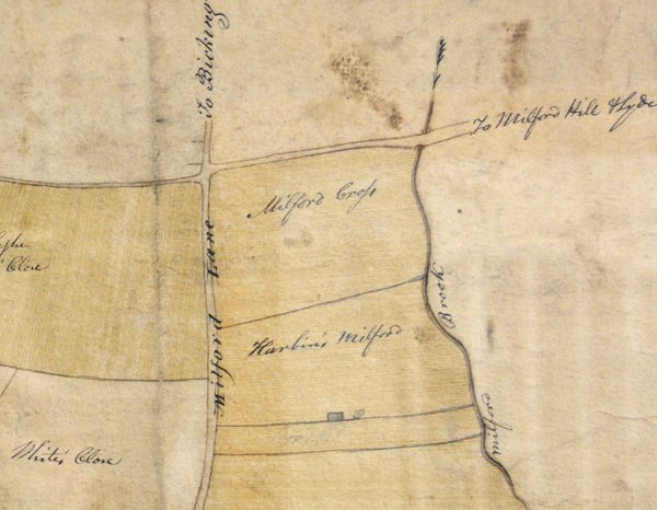
An enlarged section of the above Watts' map of Yeovil of 1806, showing the Milford Cross area that was almost certainly the location of the Turnpike side gate.