Under Newton Hill
Under Newton Hill
Now the lower western slopes of Summerhouse Hill
Under Newton Hill was originally was a large field on the lower western slopes of Newton Hill (although today we tend to call it Summerhouse Hill), adjoining the Newton Surmaville Estate.
By the time of the 1846 Tithe Apportionment, Under Newton Hill had been divided into three separate parcels (Parcels 811, 812 and 813). Parcels 811 and 812 were both owned by Revd. Edward Hansford Daniell and let to William Peach. Both parcels were recorded as pasture for grazing livestock. Parcel 811 measured 5a 0r 19p and parcel 812 measured 3a 1r 20p. Parcel 813 was owned by William Cullen and let to glove manufacturer Thomas Fooks. It too was recorded as pasture and measured 4a 1r 26p.
Under Newton Hill (Parcel 811) was bordered to the west by Dodham Brook, to the north by Under Newton Hill (Parcel 812), to the east by Higher Newton Hill (Parcel 815) and Hollow Close (Parcel 819). To the south it was bounded by Plantation (Parcel 810) and Penny's Hill (Parcel 809).
Today, the three parcels of the former Under Newton Hill are what we would today call the lower western slopes of Summerhouse Hill.
For details on historic land measurement (ie acres, roods and perches) click here.
maps

This map, based on the descriptions in the 1589 Terrier and the 1846 Tithe Map of Yeovil shows the approximate boundaries of the Manors of Kingston and Hendford as well as the manorial three-field system used in Kingston.
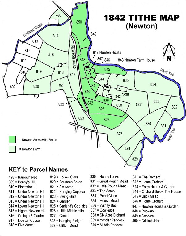
The 1842 Tithe Map showing the Newton Surmaville Estate shaded mid-green and the parcels of Newton Farm shaded light green. Under Newton Hill (Parcels 811, 812 and 813) are at the top left.
gallery
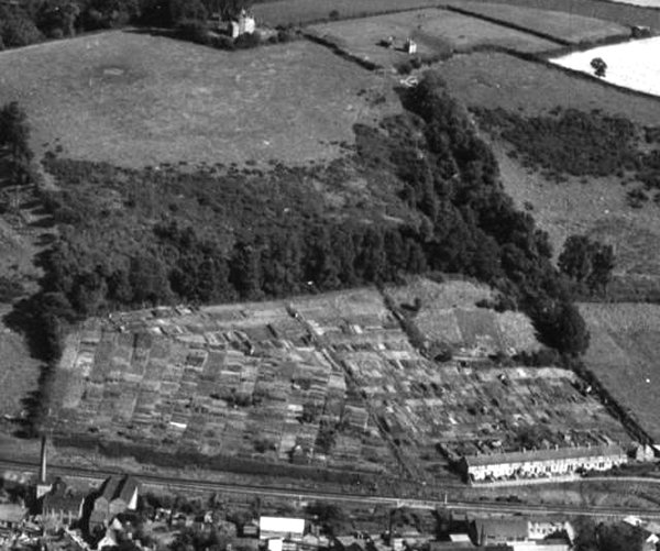
An aerial photograph of 1953, looking southeast and showing the Round House at top left of centre surmounting Newton Hill / Summerhouse Hill. The large field below it is Higher Newton Hill (Parcel 815). The patchwork of the lower slopes of the hill are allotments occupying the former Under Newton Hill (Parcels 812 and 813) with the railway line running across the bottom of the photograph. At bottom right are Victoria Buildings.