goar knap
goar knap
Triangular-shaped high ground
Goar Knap is that area of high ground containing Great Western Terrace and New Prospect Place. The name comes from the Old English gara, a gore, or triangular-shaped piece of land, and hnaep, for rising ground or the crest of a hill - both of which conditions are met here.
The 1590 Terrier, in describing the boundary of East Field states ".... from the upper part of Harder Mead down to the corner of Gore...." It was also the corner of Middle Field and the 1590 Terrier continues ".... from Gore corner next the Highway to Goldcroft Lane."
The area was also known as Ford’s Close – probably named for William Ford who flourished in the 1580’s. It was still referred to by this name as late as 1706 at which time it was also known as St Thomas' Cross, although this name is now used for a new housing development off Eastland Road to the west. In his will of 1715, Jeremiah Hayne left "... all that Close of Arrable Land lyeing at or neare a place called St Thomas Cross containing two Acres ...".
In the seventeenth century the area was known as Brightmore or Brightmore Hill. The 1633 Survey of Kingston noted that John Perry, on the surrender of John and Elizabeth Wood, held a tenement and four closes of pasture "lying at Brightmorehill" and John Selye held "a close of pasture at Brightmorehill". The will of Edward Drake dated 7 May 1668 states ".... six acres of land called Brightmore in possession of Elizabeth Marsh in Yeovil or Pitney." Elizabeth, née Burford, was the widow of Thomas Marshe (d1646).
Also in his will of 1715, Jeremiah Hayne left "... all those my Two Closes of Meadow and Pasture Ground formerly four Closes lyeing at Brightmore Hill in Kingston juxta Yeovill aforesaid within the said Parish of Yeovill containing by Estimation Nine Acres ...". It was also referred to in the 1736 will of his son Jeremiah Hayne the younger.
In his will dated 15 March 1725, John Jeanes wrote "... I give devise and bequeath the same to my Nephews Thomas Burford of [word illegible] Clerke Office in the County of Middlesex Gentleman and John Burford one of the Fellows of Kings Colledge in Cambridge Gentleman and their heires dureing the naturall life of my daughter Mary together with one ground called Milford and two acres in Gold Croft One acre in Goare field and Yeovill Bridge Mead together with all those foure peices of ground called Ryalls in the parish of Yeovill aforesaid In trust to apply and dispose of the rents issues and profitts thereof to the proper hands of my said daughter or as she shall appoint ...".
The 1832 and 1840-41 Register of Electors refers to Goar Knap and the 1846 Tithe Award notes the following parcels; 980 Goark Nap (sic), arable, 983 In Goark Nap Field, arable and 984 In Goark Nap Field, arable.
The 1854 Burgess Roll refers to Goar Knap Lane - an early name of today's St Michael's Avenue.
New Prospect Place was a long terrace of small cottages, now demolished and the land used as allotments. They were described as "simply huts with no foundations and originally having earth floors". Even so they were not demolished until 1907.
MAP
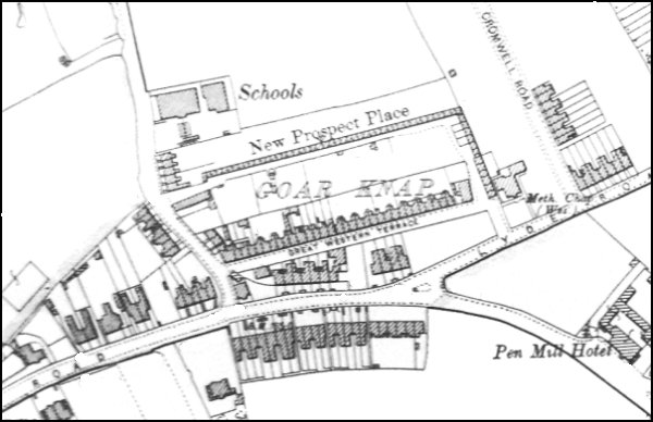
The 1901 Ordnance Survey showing Goar Knap and New Prospect Place.