Marle Close
Marle Close
A former part of the great West Field of Kingston Manor
Note: The field under discussion here called Marle Close (Parcel 1424) was near the junction of today's Stiby Road and Ilchester Road. This is not the field called Marle Close (Parcels 998 and 998a), to the north of today's Grass Royal.
![]()
Marl was originally an old term loosely applied to a variety of materials, most of which occur as loose, earthy deposits consisting chiefly of a mixture of clay and calcium carbonate. It has been used as a soil conditioner and acid soil neutralising agent and was spread on sandy soil by the Celts before the Roman occupation. Its value was realised, and its use revived, by the 'improvers' of the seventeenth and eighteenth centuries.
On the other hand, Marl was also an ancient term used to describe human waste and remote areas of sunken ground were used as a dumping ground and designated as 'marl pits'.
Originally part of the great medieval West Field of Kingston Manor, Marle Close (Parcel 1424) was a large rectangular field lying alongside the northern side of a field access track called Lower Larkhill Lane (which would become today's Stiby Road).
In his will of 1719, John Saunders the Elder left Marle Close and "threecorner Close" to his eldest son William and it is likely that William Sanders sold off both Marle Close and the adjoining Three Corner Close to John Game almost immediately since, in his will dated 1725, Edward Boucher (1) bequeathed "... Closes of pasture which I formerly purchased of John Game called Marle Close and Three Corner Close..." to his nephew Edward Boucher (2).
In his will of 1761, linen draper of the Borough and Hendford (manor of) Robert Glisson left all his lands, including Larkhill, French Grass Ground, Thorney Bush, Fir Tree Ground, New Close and Three Marle Grounds (Marle Close), to his four daughters - Betty the wife of Richard Manning, Mary the wife of John Wright, Sarah Glisson and Martha Glisson - although ensuring payments from the produce of the rents went to his widow Betty for her life. By 1777, the lands were held by Robert Glisson's daughter Mary, wife of John Wright. In a Lease for a Year of 1777, Mary leased the lands to her brothers-in-law Richard Manning of Culmstock, Devon, and Robert Winter of Sherborne, Dorset, who had married Sarah Glisson in 1767 (after her father's will). Although Martha had married Thomas Andrews in 1764, neither are mentioned in documentation referring to the lands, since Martha had died in 1767, aged 37.
In his will of 1797, banker Samuel Daniell (3) wrote "... my Close of Meadow or pasture called Male Close now Occupied by Mr Tho[ma]s Sharland in Yeovil aforesaid unto my Mother for her life...".
The 1846 Tithe Apportionment noted that Marle Close (Parcel 1424) was 10a 0r 10p and used as pasture for grazing animals and that the owner was John Glyde and the tenant was William Harrison. Marle Close (Parcel 1424) was part of Marl Close Farm and the farmhouse was set within Marle Close, on its western boundary.
Marle Close was bounded to the north by Ilchester Road, to the east by Higher Larkhill Lane(Parcel 1411) and Sealey's Mead (Parcel 1422), to the south by the farm access track called Lower Larkhill Lane (today's Stiby Road) and to the east by Three Corner Ground (Parcel 1425).
Today the site of the former Marle Close is chiefly occupied by the houses and gardens of Thatcham Park.
For details on historic land measurement (ie acres, roods and perches) click here.
maps

This map, based on the descriptions in the 1589 Terrier and the 1846 Tithe Map of Yeovil shows the approximate boundaries of the Manors of Kingston and Hendford as well as the manorial three-field system used in Kingston.
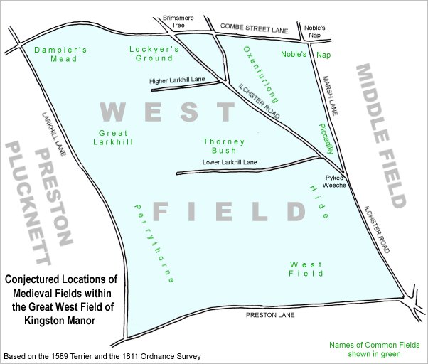
A conjectural map of the great West Field of Kingston Manor showing ancient sub-fields, most likely common fields, within the overall bounds of West Field.
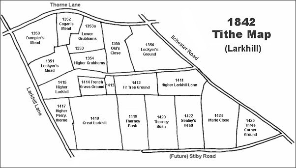
The Larkhill area reproduced from the 1842 Tithe Map. Marle Close is at bottom right.
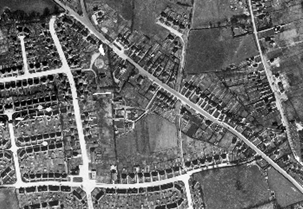
The 1946 aerial photograph. Ilchester Road runs diagonally from top left to bottom right and Stiby Road runs along the bottom of the photograph. Marle Close is at centre with Marl Close Farm within it. The western boundary, a hedge looking like a black line is visible running from Ilchester Road down to Stiby Road and running hard against the western side of the farm buildings. The eastern boundary is visible as a thin white line, probably a footpath, running in line with Alastair Drive at top, right of centre, and Westfield Grove at bottom, right of centre.
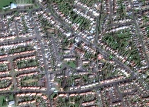
The same area today 'borrowed' from Google maps.
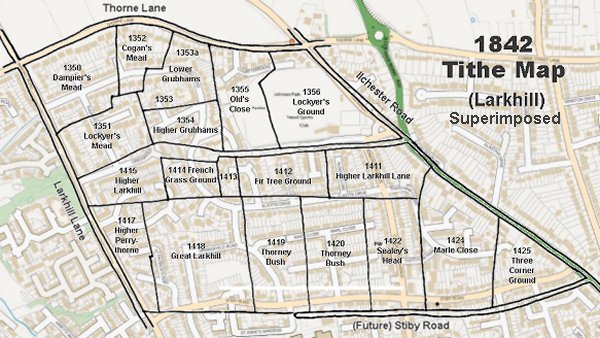
The 1842 Tithe Map superimposed (slightly out at the bottom) over a modern map.